Andrésy elevation
Andrésy (Île-de-France, Yvelines), France elevation is 62 meters and Andrésy elevation in feet is 203 ft above sea level [src 1]. Andrésy is a populated place (feature code) with elevation that is 112 meters (367 ft) smaller than average city elevation in France.
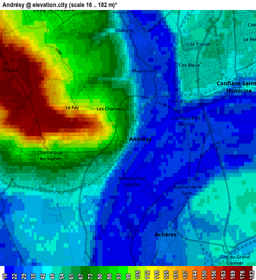
Below is the Elevation map of Andrésy, which displays elevation range with different colors. Scale of the first map is from 16 to 182 m (52 to 597 ft) with average elevation of 57.4 meters (=188 ft) [note 1]
These maps also provides idea of topography and contour of this city, they are displayed at different zoom levels. More info about maps, scale and edge coordinates you can find below images.
| \ | Map #1 | Map #2 | Topo.Map |
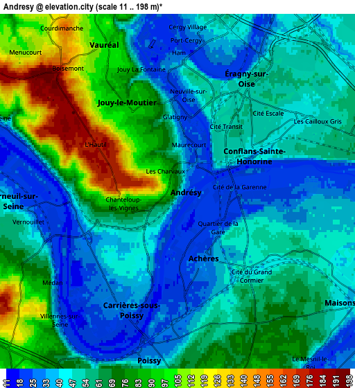
| Scale [m] | 16..182 m | 11..198 m | × |
| Scale [ft] | 52..597 ft | 36..650 ft | × |
| Average | 57.4 m = 188 ft | 59.1 m = 194 ft | × |
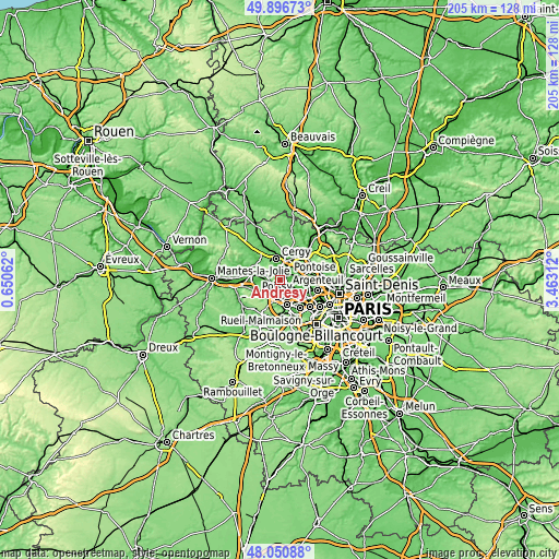
| Width | 6.41 km = 4 mi | 12.83 km = 8 mi | 205.2 km = 127.5 mi |
| Height | 6.41 km = 4 mi | 12.83 km = 8 mi | 205.2 km = 127.5 mi |
| ↑Max Latitude | 49.011183° | 49.039998° | 49.89673° |
| Latitude at center | 48.98235° | 48.98235° | 48.98235° |
| ↓Min Latitude | 48.953501° | 48.924635° | 48.05088° |
| ← Min Longitude | 2.012925° | 1.968979° | 0.65062° |
| Longitude center | 2.05687° | 2.05687° | 2.05687° |
| →Max Longitude | 2.100815° | 2.144761° | 3.46312° |
Nearby cities:
Cities around Andrésy sort by population:
• Conflans-Sainte-Honorine elevation 48 m
3.6 km,  53°
53°
• Achères 29 m
2.5 km,  159°
159°
• Vauréal 41 m
5.9 km,  343°
343°
• Jouy-le-Moutier 88 m
3.4 km, 338°
• Carrières-sous-Poissy 35 m
3.8 km,  197°
197°
• Éragny 54 m
4.9 km,  39°
39°
• Triel-sur-Seine 51 m
3.6 km,  262°
262°
• Vernouillet 52 m
5.7 km, 257°
• Chanteloup-les-Vignes 76 m
1.9 km,  248°
248°
• Maurecourt 27 m
1.6 km,  12°
12°
• Neuville-sur-Oise 48 m
3.9 km, 10°
• Médan 40 m
5.4 km,  236°
236°
Multilingual:
 En español:
Andrésy elevación 62 m.
 En France:
Andrésy élévation 62 m.


Sources and notes:
- [note 1] Map square and city borders are not equal. Map elevation data is calculated only from area inside that square.
- [src 1] Elevation data from geonames database provided with same terms of usage.
- [src 2] The elevation map of Andrésy is generated using elevation data from NASA's 3 arcsec (90m) resolution SRTM data.
- [src 3] Base (background) map © OpenStreetMap contributors tiles are generated by Geofabrik and OpenTopoMap.
Copyright & License:
This Andrésy Elevation Map is licensed under CC BY-SA. You may reuse any part from this page, if you give a proper credit by linking to this URL:
 More info on terms of use page.