Antibes elevation
Antibes (Provence-Alpes-Côte d'Azur, Alpes-Maritimes), France elevation is 39 meters and Antibes elevation in feet is 128 ft above sea level [src 1]. Antibes is a populated place (feature code) with elevation that is 135 meters (443 ft) smaller than average city elevation in France.
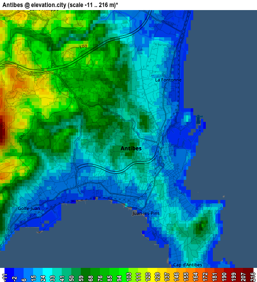
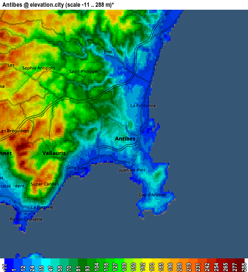
Below is the Elevation map of Antibes, which displays elevation range with different colors. Scale of the first map is from -11 to 216 m (-36 to 709 ft) with average elevation of 51.3 meters (=168 ft) [note 1]
These maps also provides idea of topography and contour of this city, they are displayed at different zoom levels. More info about maps, scale and edge coordinates you can find below images.
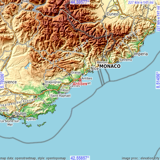
| \ | Map #1 | Map #2 | Topo.Map |
| Scale [m] | -11..216 m | -11..288 m | × |
| Scale [ft] | -36..709 ft | -36..945 ft | × |
| Average | 51.3 m = 168 ft | 99.8 m = 327 ft | × |
| Width | 7.08 km = 4.4 mi | 14.16 km = 8.8 mi | 226.5 km = 140.7 mi |
| Height | 7.08 km = 4.4 mi | 14.16 km = 8.8 mi | 226.5 km = 140.7 mi |
| ↑Max Latitude | 43.617613° | 43.649419° | 44.59577° |
| Latitude at center | 43.58579° | 43.58579° | 43.58579° |
| ↓Min Latitude | 43.55395° | 43.522093° | 42.55857° |
| ← Min Longitude | 7.064365° | 7.020419° | 5.70206° |
| Longitude center | 7.10831° | 7.10831° | 7.10831° |
| →Max Longitude | 7.152255° | 7.196201° | 8.51456° |
Nearby cities:
Cities around Antibes sort by population:
• Cannes elevation 11 m
8.6 km,  243°
243°
• Cagnes-sur-Mer 14 m
9.2 km,  20°
20°
• Le Cannet 94 m
7.3 km,  261°
261°
• Saint-Laurent-du-Var 10 m
11.7 km,  34°
34°
• Vallauris 115 m
4.4 km, 258°
• Mougins 180 m
9.3 km,  280°
280°
• Villeneuve-Loubet 13 m
8.1 km,  8°
8°
• Valbonne 232 m
10.2 km,  300°
300°
• Mouans-Sartoux 150 m
11.7 km,  289°
289°
• Biot 72 m
4.9 km,  347°
347°
• La Colle-sur-Loup 80 m
11.2 km,  358°
358°
• La Roquette-sur-Siagne 155 m
12.3 km, 276°
Multilingual:
 En español:
Antibes elevación 39 m.
 En France:
Antibes élévation 39 m.


Sources and notes:
- [note 1] Map square and city borders are not equal. Map elevation data is calculated only from area inside that square.
- [src 1] Elevation data from geonames database provided with same terms of usage.
- [src 2] The elevation map of Antibes is generated using elevation data from NASA's 3 arcsec (90m) resolution SRTM data.
- [src 3] Base (background) map © OpenStreetMap contributors tiles are generated by Geofabrik and OpenTopoMap.
Copyright & License:
This Antibes Elevation Map is licensed under CC BY-SA. You may reuse any part from this page, if you give a proper credit by linking to this URL:
 More info on terms of use page.