Argancy elevation
Argancy (Grand Est, Moselle), France elevation is 175 meters and Argancy elevation in feet is 574 ft above sea level [src 1]. Argancy is a populated place (feature code) with elevation that is 1 meters (3 ft) bigger than average city elevation in France.
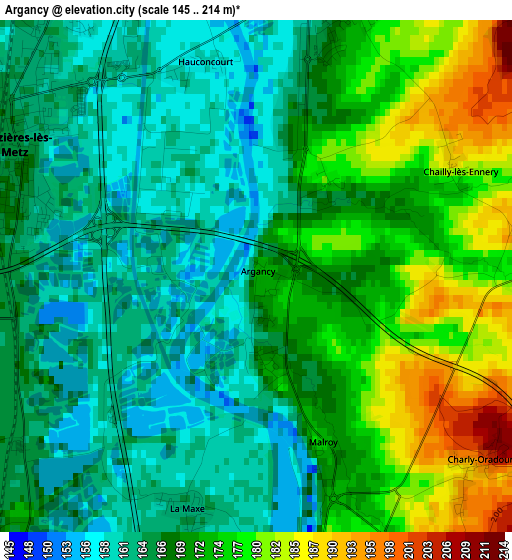
Below is the Elevation map of Argancy, which displays elevation range with different colors. Scale of the first map is from 145 to 214 m (476 to 702 ft) with average elevation of 169.5 meters (=556 ft) [note 1]
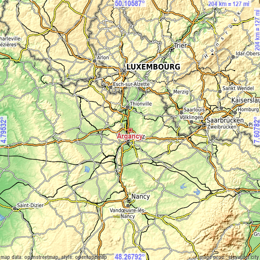
These maps also provides idea of topography and contour of this city, they are displayed at different zoom levels. More info about maps, scale and edge coordinates you can find below images.
| \ | Map #1 | Topo.Map |
| Scale [m] | 145..214 m | × |
| Scale [ft] | 476..702 ft | × |
| Average | 169.5 m = 556 ft | × |
| Width | 6.39 km = 4 mi | 204.4 km = 127 mi |
| Height | 6.39 km = 4 mi | 204.3 km = 126.9 mi |
| ↑Max Latitude | 49.224139° | 50.10587° |
| Latitude at center | 49.19543° | 49.19543° |
| ↓Min Latitude | 49.166704° | 48.26792° |
| ← Min Longitude | 6.157625° | 4.79532° |
| Longitude center | 6.20157° | 6.20157° |
| →Max Longitude | 6.245515° | 7.60782° |
Nearby cities:
Cities around Argancy sort by population:
• Woippy elevation 166 m
6.1 km,  216°
216°
• Maizières-lès-Metz 162 m
3.6 km,  303°
303°
• Hagondange 160 m
6.5 km,  335°
335°
• Talange 158 m
5 km,  334°
334°
• Mondelange 160 m
7.8 km, 340°
• Marange-Silvange 217 m
7.2 km,  281°
281°
• Saint-Julien-lès-Metz 187 m
7 km,  179°
179°
• Ennery 170 m
3.6 km,  18°
18°
• Ay-sur-Moselle 169 m
5.3 km,  3°
3°
• Pierrevillers 222 m
7.8 km,  294°
294°
• Vigy 263 m
7.2 km,  81°
81°
• Trémery 173 m
5.9 km, 15°
Multilingual:
 En español:
Argancy elevación 175 m.
 En France:
Argancy élévation 175 m.


Sources and notes:
- [note 1] Map square and city borders are not equal. Map elevation data is calculated only from area inside that square.
- [src 1] Elevation data from geonames database provided with same terms of usage.
- [src 2] The elevation map of Argancy is generated using elevation data from NASA's 3 arcsec (90m) resolution SRTM data.
- [src 3] Base (background) map © OpenStreetMap contributors tiles are generated by Geofabrik and OpenTopoMap.
Copyright & License:
This Argancy Elevation Map is licensed under CC BY-SA. You may reuse any part from this page, if you give a proper credit by linking to this URL:
 More info on terms of use page.