Aubagne elevation
Aubagne (Provence-Alpes-Côte d'Azur, Département des Bouches-du-Rhône), France elevation is 120 meters and Aubagne elevation in feet is 394 ft above sea level [src 1]. Aubagne is a populated place (feature code) with elevation that is 54 meters (177 ft) smaller than average city elevation in France.
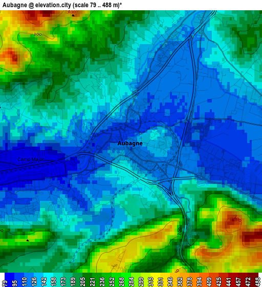
Below is the Elevation map of Aubagne, which displays elevation range with different colors. Scale of the first map is from 79 to 488 m (259 to 1601 ft) with average elevation of 177.3 meters (=582 ft) [note 1]
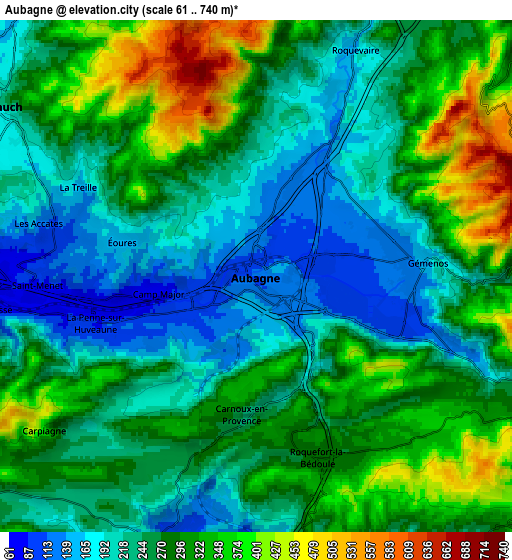
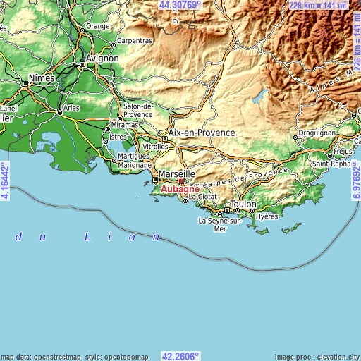
These maps also provides idea of topography and contour of this city, they are displayed at different zoom levels. More info about maps, scale and edge coordinates you can find below images.
| \ | Map #1 | Map #2 | Topo.Map |
| Scale [m] | 79..488 m | 61..740 m | × |
| Scale [ft] | 259..1601 ft | 200..2428 ft | × |
| Average | 177.3 m = 582 ft | 269 m = 883 ft | × |
| Width | 7.11 km = 4.4 mi | 14.23 km = 8.8 mi | 227.6 km = 141.4 mi |
| Height | 7.11 km = 4.4 mi | 14.23 km = 8.8 mi | 227.6 km = 141.4 mi |
| ↑Max Latitude | 43.324738° | 43.356698° | 44.30769° |
| Latitude at center | 43.29276° | 43.29276° | 43.29276° |
| ↓Min Latitude | 43.260766° | 43.228754° | 42.2606° |
| ← Min Longitude | 5.526725° | 5.482779° | 4.16442° |
| Longitude center | 5.57067° | 5.57067° | 5.57067° |
| →Max Longitude | 5.614615° | 5.658561° | 6.97692° |
Nearby cities:
Cities around Aubagne sort by population:
• Roquevaire elevation 160 m
6.9 km,  22°
22°
• Carnoux-en-Provence 251 m
4.1 km,  187°
187°
• La Penne-sur-Huveaune 79 m
4.5 km,  254°
254°
• Gémenos 152 m
4.7 km,  83°
83°
• Roquefort-la-Bédoule 287 m
5.1 km,  162°
162°
• Les Camoins 162 m
4.6 km,  288°
288°
• La Valentine 82 m
7 km,  274°
274°
• La Millère 92 m
6 km,  257°
257°
• La Barasse 74 m
6.9 km, 262°
• Saint-Menet 80 m
5.4 km, 266°
• Les Accates 118 m
6 km,  277°
277°
• Éoures 149 m
4 km, 282°
Multilingual:
 En español:
Aubagne elevación 120 m.
 En France:
Aubagne élévation 120 m.


Sources and notes:
- [note 1] Map square and city borders are not equal. Map elevation data is calculated only from area inside that square.
- [src 1] Elevation data from geonames database provided with same terms of usage.
- [src 2] The elevation map of Aubagne is generated using elevation data from NASA's 3 arcsec (90m) resolution SRTM data.
- [src 3] Base (background) map © OpenStreetMap contributors tiles are generated by Geofabrik and OpenTopoMap.
Copyright & License:
This Aubagne Elevation Map is licensed under CC BY-SA. You may reuse any part from this page, if you give a proper credit by linking to this URL:
 More info on terms of use page.