Audun-le-Tiche elevation
Audun-le-Tiche (Grand Est, Moselle), France elevation is 377 meters and Audun-le-Tiche elevation in feet is 1237 ft above sea level [src 1]. Audun-le-Tiche is a populated place (feature code) with elevation that is 203 meters (666 ft) bigger than average city elevation in France.
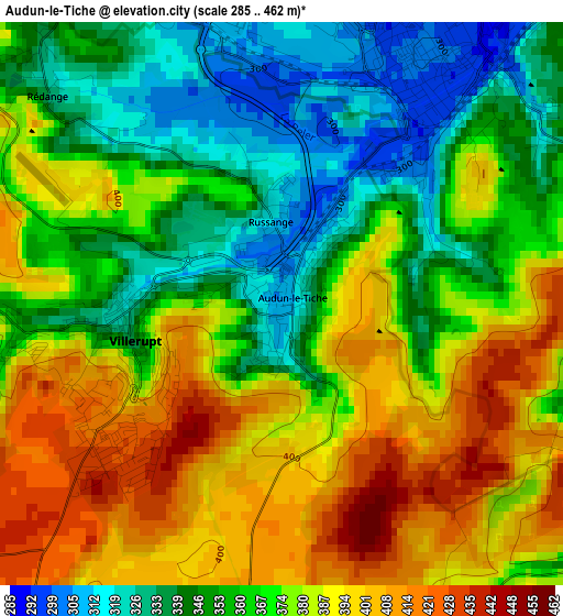
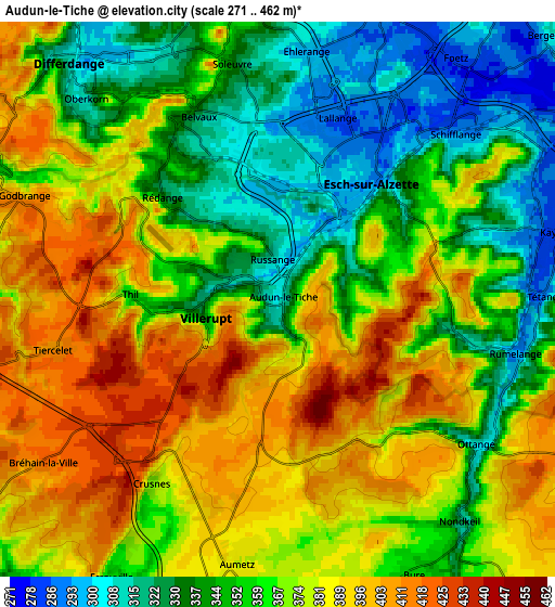
Below is the Elevation map of Audun-le-Tiche, which displays elevation range with different colors. Scale of the first map is from 285 to 462 m (935 to 1516 ft) with average elevation of 370.6 meters (=1216 ft) [note 1]
These maps also provides idea of topography and contour of this city, they are displayed at different zoom levels. More info about maps, scale and edge coordinates you can find below images.
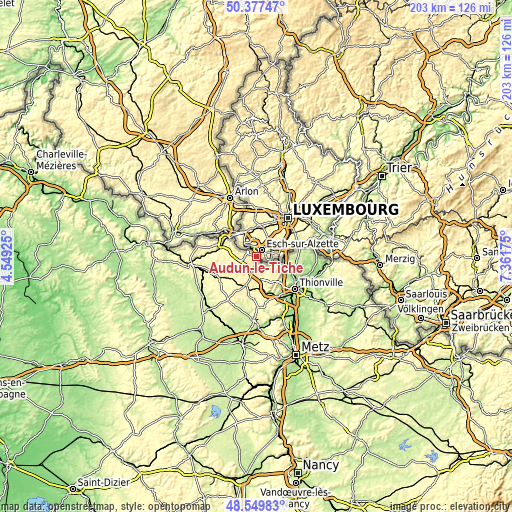
| \ | Map #1 | Map #2 | Topo.Map |
| Scale [m] | 285..462 m | 271..462 m | × |
| Scale [ft] | 935..1516 ft | 889..1516 ft | × |
| Average | 370.6 m = 1216 ft | 365.7 m = 1200 ft | × |
| Width | 6.35 km = 3.9 mi | 12.7 km = 7.9 mi | 203.2 km = 126.3 mi |
| Height | 6.35 km = 3.9 mi | 12.7 km = 7.9 mi | 203.2 km = 126.3 mi |
| ↑Max Latitude | 49.500718° | 49.52925° | 50.37747° |
| Latitude at center | 49.47217° | 49.47217° | 49.47217° |
| ↓Min Latitude | 49.443605° | 49.415024° | 48.54983° |
| ← Min Longitude | 5.911555° | 5.867609° | 4.54925° |
| Longitude center | 5.9555° | 5.9555° | 5.9555° |
| →Max Longitude | 5.999445° | 6.043391° | 7.36175° |
Nearby cities:
Cities around Audun-le-Tiche sort by population:
• Villerupt elevation 337 m
1.8 km,  251°
251°
• Hussigny-Godbrange 390 m
6.9 km,  291°
291°
• Haucourt 377 m
11.1 km,  280°
280°
• Ottange 371 m
5.7 km,  124°
124°
• Aumetz 379 m
6.1 km,  187°
187°
• Tressange 339 m
7.9 km,  166°
166°
• Boulange 318 m
10 km,  182°
182°
• Volmerange-les-Mines 309 m
9.6 km,  109°
109°
• Crusnes 370 m
5.1 km,  214°
214°
• Thil 370 m
3.4 km,  271°
271°
• Villers-la-Montagne 390 m
9.4 km, 269°
• Russange 320 m
1.2 km,  348°
348°
Multilingual:
 En español:
Audun-le-Tiche elevación 377 m.
 En France:
Audun-le-Tiche élévation 377 m.
 Auf Deutsch:
Audun-le-Tiche höhe über dem Meeresspiegel ist 377 m.

Sources and notes:
- [note 1] Map square and city borders are not equal. Map elevation data is calculated only from area inside that square.
- [src 1] Elevation data from geonames database provided with same terms of usage.
- [src 2] The elevation map of Audun-le-Tiche is generated using elevation data from NASA's 3 arcsec (90m) resolution SRTM data.
- [src 3] Base (background) map © OpenStreetMap contributors tiles are generated by Geofabrik and OpenTopoMap.
Copyright & License:
This Audun-le-Tiche Elevation Map is licensed under CC BY-SA. You may reuse any part from this page, if you give a proper credit by linking to this URL:
 More info on terms of use page.