Balma elevation
Balma (Occitanie, Haute-Garonne), France elevation is 160 meters and Balma elevation in feet is 525 ft above sea level [src 1]. Balma is a populated place (feature code) with elevation that is 14 meters (46 ft) smaller than average city elevation in France.
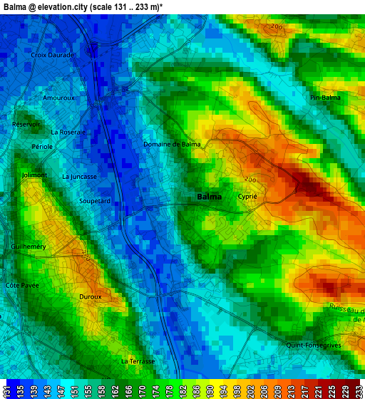
Below is the Elevation map of Balma, which displays elevation range with different colors. Scale of the first map is from 131 to 233 m (430 to 764 ft) with average elevation of 165.2 meters (=542 ft) [note 1]
These maps also provides idea of topography and contour of this city, they are displayed at different zoom levels. More info about maps, scale and edge coordinates you can find below images.
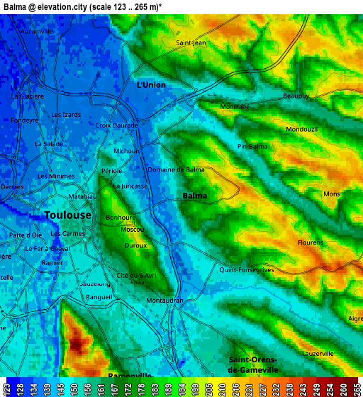
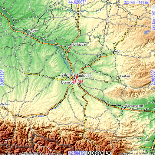
| \ | Map #1 | Map #2 | Topo.Map |
| Scale [m] | 131..233 m | 123..265 m | × |
| Scale [ft] | 430..764 ft | 404..869 ft | × |
| Average | 165.2 m = 542 ft | 165.8 m = 544 ft | × |
| Width | 7.08 km = 4.4 mi | 14.15 km = 8.8 mi | 226.4 km = 140.7 mi |
| Height | 7.08 km = 4.4 mi | 14.15 km = 8.8 mi | 226.4 km = 140.7 mi |
| ↑Max Latitude | 43.64292° | 43.674712° | 44.62067° |
| Latitude at center | 43.61111° | 43.61111° | 43.61111° |
| ↓Min Latitude | 43.579284° | 43.54744° | 42.58432° |
| ← Min Longitude | 1.455495° | 1.411549° | 0.09319° |
| Longitude center | 1.49944° | 1.49944° | 1.49944° |
| →Max Longitude | 1.543385° | 1.587331° | 2.90569° |
Nearby cities:
Cities around Balma sort by population:
• Toulouse elevation 150 m
4.6 km,  260°
260°
• Saint-Orens-de-Gameville 201 m
6.9 km,  156°
156°
• Ramonville-Saint-Agne 163 m
7.5 km,  195°
195°
• L'Union 180 m
5.6 km,  346°
346°
• Saint-Jean 206 m
5.9 km,  359°
359°
• Launaguet 137 m
8.2 km,  334°
334°
• Montrabé 150 m
4.2 km,  27°
27°
• Castelmaurou 230 m
7.9 km,  19°
19°
• Flourens 225 m
5.5 km,  111°
111°
• Rouffiac-Tolosan 216 m
6.4 km, 18°
• Beaupuy 163 m
6 km,  48°
48°
• Mons 219 m
5.8 km,  88°
88°
Multilingual:
 En español:
Balma elevación 160 m.
 En France:
Balma élévation 160 m.


Sources and notes:
- [note 1] Map square and city borders are not equal. Map elevation data is calculated only from area inside that square.
- [src 1] Elevation data from geonames database provided with same terms of usage.
- [src 2] The elevation map of Balma is generated using elevation data from NASA's 3 arcsec (90m) resolution SRTM data.
- [src 3] Base (background) map © OpenStreetMap contributors tiles are generated by Geofabrik and OpenTopoMap.
Copyright & License:
This Balma Elevation Map is licensed under CC BY-SA. You may reuse any part from this page, if you give a proper credit by linking to this URL:
 More info on terms of use page.