Bavay elevation
Bavay (Hauts-de-France, Nord), France elevation is 149 meters and Bavay elevation in feet is 489 ft above sea level [src 1]. Bavay is a populated place (feature code) with elevation that is 25 meters (82 ft) smaller than average city elevation in France.
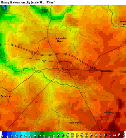
Below is the Elevation map of Bavay, which displays elevation range with different colors. Scale of the first map is from 37 to 173 m (121 to 568 ft) with average elevation of 134.9 meters (=443 ft) [note 1]
These maps also provides idea of topography and contour of this city, they are displayed at different zoom levels. More info about maps, scale and edge coordinates you can find below images.
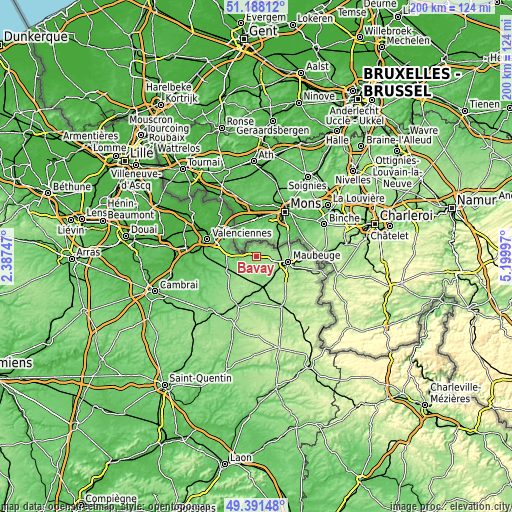
| \ | Map #1 | Topo.Map |
| Scale [m] | 37..173 m | × |
| Scale [ft] | 121..568 ft | × |
| Average | 134.9 m = 443 ft | × |
| Width | 6.24 km = 3.9 mi | 199.8 km = 124.1 mi |
| Height | 6.24 km = 3.9 mi | 199.8 km = 124.1 mi |
| ↑Max Latitude | 50.326344° | 51.18812° |
| Latitude at center | 50.29828° | 50.29828° |
| ↓Min Latitude | 50.2702° | 49.39148° |
| ← Min Longitude | 3.749775° | 2.38747° |
| Longitude center | 3.79372° | 3.79372° |
| →Max Longitude | 3.837665° | 5.19997° |
Nearby cities:
Cities around Bavay sort by population:
• Hautmont elevation 141 m
10.5 km,  120°
120°
• Aulnoye-Aymeries 149 m
11.2 km,  163°
163°
• Feignies 149 m
8.6 km,  90°
90°
• Le Quesnoy 129 m
12.5 km,  243°
243°
• Berlaimont 143 m
10.8 km,  172°
172°
• Pont-sur-Sambre 132 m
9.3 km, 155°
• Bachant 143 m
10.6 km,  150°
150°
• La Longueville 145 m
4.6 km,  102°
102°
• Gommegnies 127 m
6.9 km, 244°
• Sebourg 86 m
11.7 km,  294°
294°
• Jenlain 99 m
11.8 km,  277°
277°
• Wargnies-le-Grand 88 m
9.5 km, 276°
Multilingual:
 En español:
Bavay elevación 149 m.
 En France:
Bavay élévation 149 m.


Sources and notes:
- [note 1] Map square and city borders are not equal. Map elevation data is calculated only from area inside that square.
- [src 1] Elevation data from geonames database provided with same terms of usage.
- [src 2] The elevation map of Bavay is generated using elevation data from NASA's 3 arcsec (90m) resolution SRTM data.
- [src 3] Base (background) map © OpenStreetMap contributors tiles are generated by Geofabrik and OpenTopoMap.
Copyright & License:
This Bavay Elevation Map is licensed under CC BY-SA. You may reuse any part from this page, if you give a proper credit by linking to this URL:
 More info on terms of use page.