Bayon elevation
Bayon (Grand Est, Meurthe-et-Moselle), France elevation is 264 meters and Bayon elevation in feet is 866 ft above sea level [src 1]. Bayon is a populated place (feature code) with elevation that is 90 meters (295 ft) bigger than average city elevation in France.
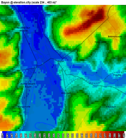
Below is the Elevation map of Bayon, which displays elevation range with different colors. Scale of the first map is from 234 to 403 m (768 to 1322 ft) with average elevation of 286 meters (=938 ft) [note 1]
These maps also provides idea of topography and contour of this city, they are displayed at different zoom levels. More info about maps, scale and edge coordinates you can find below images.
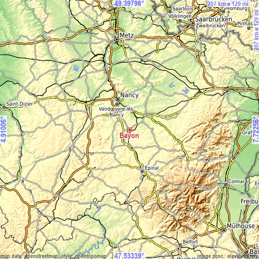
| \ | Map #1 | Topo.Map |
| Scale [m] | 234..403 m | × |
| Scale [ft] | 768..1322 ft | × |
| Average | 286 m = 938 ft | × |
| Width | 6.48 km = 4 mi | 207.3 km = 128.8 mi |
| Height | 6.48 km = 4 mi | 207.3 km = 128.8 mi |
| ↑Max Latitude | 48.503375° | 49.39798° |
| Latitude at center | 48.47425° | 48.47425° |
| ↓Min Latitude | 48.445108° | 47.53339° |
| ← Min Longitude | 6.272365° | 4.91006° |
| Longitude center | 6.31631° | 6.31631° |
| →Max Longitude | 6.360255° | 7.72256° |
Nearby cities:
Cities around Bayon sort by population:
• Dombasle-sur-Meurthe elevation 220 m
16.3 km,  10°
10°
• Saint-Nicolas-de-Port 215 m
17.2 km,  355°
355°
• Charmes 282 m
11.5 km,  189°
189°
• Richardménil 280 m
17.1 km,  320°
320°
• Rosières-aux-Salines 208 m
13.3 km,  4°
4°
• Damelevières 223 m
10.7 km,  27°
27°
• Vincey 296 m
15.2 km,  175°
175°
• Flavigny-sur-Moselle 246 m
13.8 km, 317°
• Gerbéviller 249 m
14.5 km,  80°
80°
• Vézelise 257 m
16.9 km,  275°
275°
• Portieux 296 m
14.6 km,  171°
171°
• Pulligny 288 m
14.6 km,  299°
299°
Multilingual:
 En español:
Bayon elevación 264 m.
 En France:
Bayon élévation 264 m.


Sources and notes:
- [note 1] Map square and city borders are not equal. Map elevation data is calculated only from area inside that square.
- [src 1] Elevation data from geonames database provided with same terms of usage.
- [src 2] The elevation map of Bayon is generated using elevation data from NASA's 3 arcsec (90m) resolution SRTM data.
- [src 3] Base (background) map © OpenStreetMap contributors tiles are generated by Geofabrik and OpenTopoMap.
Copyright & License:
This Bayon Elevation Map is licensed under CC BY-SA. You may reuse any part from this page, if you give a proper credit by linking to this URL:
 More info on terms of use page.