Béganne elevation
Béganne (Brittany, Morbihan), France elevation is 59 meters and Béganne elevation in feet is 194 ft above sea level [src 1]. Béganne is a populated place (feature code) with elevation that is 115 meters (377 ft) smaller than average city elevation in France.
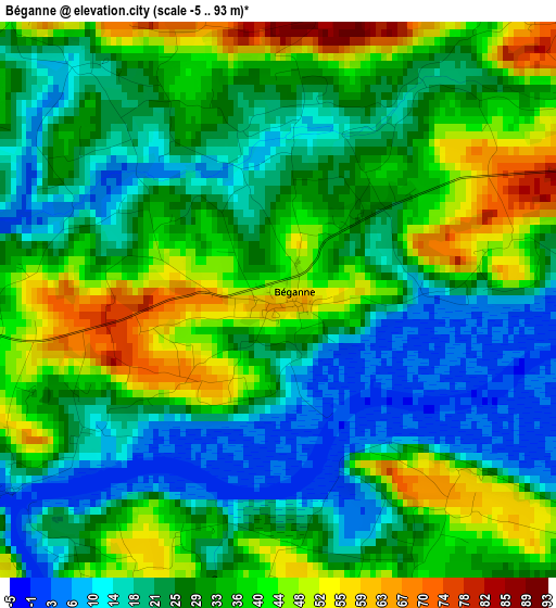
Below is the Elevation map of Béganne, which displays elevation range with different colors. Scale of the first map is from -5 to 93 m (-16 to 305 ft) with average elevation of 30.5 meters (=100 ft) [note 1]
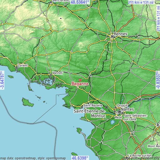
These maps also provides idea of topography and contour of this city, they are displayed at different zoom levels. More info about maps, scale and edge coordinates you can find below images.
| \ | Map #1 | Topo.Map |
| Scale [m] | -5..93 m | × |
| Scale [ft] | -16..305 ft | × |
| Average | 30.5 m = 100 ft | × |
| Width | 6.59 km = 4.1 mi | 210.9 km = 131 mi |
| Height | 6.59 km = 4.1 mi | 210.9 km = 131 mi |
| ↑Max Latitude | 47.626326° | 48.53641° |
| Latitude at center | 47.5967° | 47.5967° |
| ↓Min Latitude | 47.567057° | 46.6398° |
| ← Min Longitude | -2.285565° | -3.64787° |
| Longitude center | -2.24162° | -2.24162° |
| →Max Longitude | -2.197675° | -0.83537° |
Nearby cities:
Cities around Béganne sort by population:
• Nivillac elevation 24 m
7.7 km,  203°
203°
• Allaire 66 m
7.4 km,  52°
52°
• Rieux 24 m
10 km,  89°
89°
• Péaule 86 m
8.8 km,  257°
257°
• Saint-Dolay 49 m
8.7 km,  131°
131°
• Malansac 86 m
9.8 km,  335°
335°
• Marzan 48 m
8.8 km,  225°
225°
• Saint-Jacut-les-Pins 58 m
10.1 km,  11°
11°
• Caden 71 m
5.1 km,  318°
318°
• Saint-Jean-la-Poterie 47 m
9.8 km,  63°
63°
• Limerzel 63 m
9.5 km,  297°
297°
• Saint-Perreux 17 m
12.9 km, 51°
Multilingual:
 En español:
Béganne elevación 59 m.
 En France:
Béganne élévation 59 m.


Sources and notes:
- [note 1] Map square and city borders are not equal. Map elevation data is calculated only from area inside that square.
- [src 1] Elevation data from geonames database provided with same terms of usage.
- [src 2] The elevation map of Béganne is generated using elevation data from NASA's 3 arcsec (90m) resolution SRTM data.
- [src 3] Base (background) map © OpenStreetMap contributors tiles are generated by Geofabrik and OpenTopoMap.
Copyright & License:
This Béganne Elevation Map is licensed under CC BY-SA. You may reuse any part from this page, if you give a proper credit by linking to this URL:
 More info on terms of use page.