Behren-lès-Forbach elevation
Behren-lès-Forbach (Grand Est, Moselle), France elevation is 305 meters and Behren-lès-Forbach elevation in feet is 1001 ft above sea level [src 1]. Behren-lès-Forbach is a populated place (feature code) with elevation that is 131 meters (430 ft) bigger than average city elevation in France.
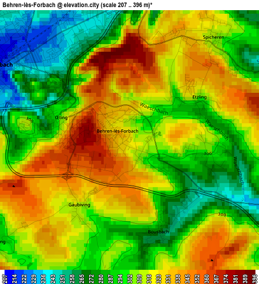
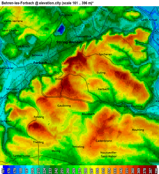
Below is the Elevation map of Behren-lès-Forbach, which displays elevation range with different colors. Scale of the first map is from 207 to 396 m (679 to 1299 ft) with average elevation of 306.8 meters (=1007 ft) [note 1]
These maps also provides idea of topography and contour of this city, they are displayed at different zoom levels. More info about maps, scale and edge coordinates you can find below images.
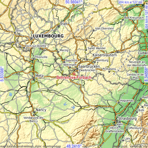
| \ | Map #1 | Map #2 | Topo.Map |
| Scale [m] | 207..396 m | 161..396 m | × |
| Scale [ft] | 679..1299 ft | 528..1299 ft | × |
| Average | 306.8 m = 1007 ft | 278.5 m = 914 ft | × |
| Width | 6.39 km = 4 mi | 12.78 km = 7.9 mi | 204.5 km = 127.1 mi |
| Height | 6.39 km = 4 mi | 12.78 km = 7.9 mi | 204.5 km = 127.1 mi |
| ↑Max Latitude | 49.198214° | 49.226922° | 50.08041° |
| Latitude at center | 49.16949° | 49.16949° | 49.16949° |
| ↓Min Latitude | 49.140749° | 49.111992° | 48.2415° |
| ← Min Longitude | 6.895385° | 6.851439° | 5.53308° |
| Longitude center | 6.93933° | 6.93933° | 6.93933° |
| →Max Longitude | 6.983275° | 7.027221° | 8.34558° |
Nearby cities:
Cities around Behren-lès-Forbach sort by population:
• Forbach elevation 230 m
4 km,  301°
301°
• Stiring-Wendel 221 m
3.7 km,  351°
351°
• Spicheren 309 m
3.2 km,  37°
37°
• Schœneck 233 m
5.5 km,  342°
342°
• Alsting 257 m
4.1 km,  70°
70°
• Morsbach 221 m
4.9 km,  268°
268°
• Théding 310 m
5.7 km,  216°
216°
• Œting 370 m
1.8 km,  281°
281°
• Folkling 294 m
4.1 km,  233°
233°
• Etzling 338 m
1.8 km,  51°
51°
• Tenteling 319 m
4.9 km,  181°
181°
• Kerbach 284 m
1.9 km,  98°
98°
Multilingual:
 En español:
Behren-lès-Forbach elevación 305 m.
 En France:
Behren-lès-Forbach élévation 305 m.
 Auf Deutsch:
Behren-lès-Forbach höhe über dem Meeresspiegel ist 305 m.
 На русском:
Behren-lès-Forbach высота над уровнем моря 305 м
Sources and notes:
- [note 1] Map square and city borders are not equal. Map elevation data is calculated only from area inside that square.
- [src 1] Elevation data from geonames database provided with same terms of usage.
- [src 2] The elevation map of Behren-lès-Forbach is generated using elevation data from NASA's 3 arcsec (90m) resolution SRTM data.
- [src 3] Base (background) map © OpenStreetMap contributors tiles are generated by Geofabrik and OpenTopoMap.
Copyright & License:
This Behren-lès-Forbach Elevation Map is licensed under CC BY-SA. You may reuse any part from this page, if you give a proper credit by linking to this URL:
 More info on terms of use page.