Belloy-en-France elevation
Belloy-en-France (Île-de-France, Département du Val-d’Oise), France elevation is 120 meters and Belloy-en-France elevation in feet is 394 ft above sea level [src 1]. Belloy-en-France is a populated place (feature code) with elevation that is 54 meters (177 ft) smaller than average city elevation in France.
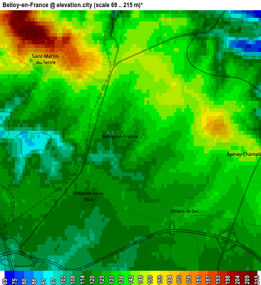
Below is the Elevation map of Belloy-en-France, which displays elevation range with different colors. Scale of the first map is from 69 to 215 m (226 to 705 ft) with average elevation of 129.3 meters (=424 ft) [note 1]
These maps also provides idea of topography and contour of this city, they are displayed at different zoom levels. More info about maps, scale and edge coordinates you can find below images.
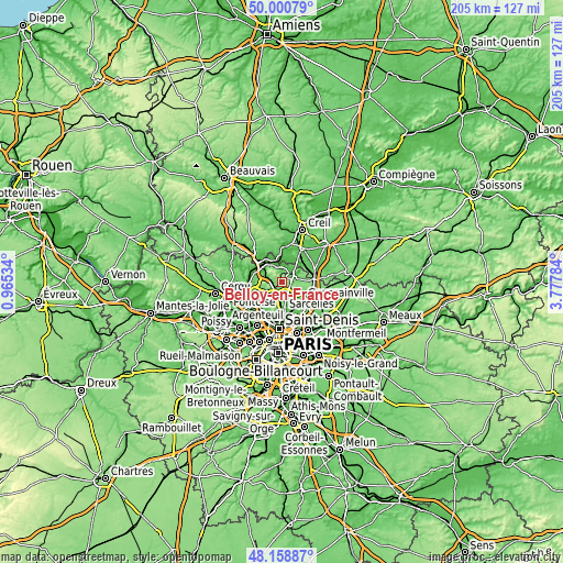
| \ | Map #1 | Topo.Map |
| Scale [m] | 69..215 m | × |
| Scale [ft] | 226..705 ft | × |
| Average | 129.3 m = 424 ft | × |
| Width | 6.4 km = 4 mi | 204.8 km = 127.3 mi |
| Height | 6.4 km = 4 mi | 204.8 km = 127.3 mi |
| ↑Max Latitude | 49.117141° | 50.00079° |
| Latitude at center | 49.08837° | 49.08837° |
| ↓Min Latitude | 49.059582° | 48.15887° |
| ← Min Longitude | 2.327645° | 0.96534° |
| Longitude center | 2.37159° | 2.37159° |
| →Max Longitude | 2.415535° | 3.77784° |
Nearby cities:
Cities around Belloy-en-France sort by population:
• Ézanville elevation 81 m
6.7 km,  182°
182°
• Viarmes 49 m
4.7 km,  359°
359°
• Luzarches 75 m
4.6 km,  53°
53°
• Montsoult 120 m
4.3 km,  240°
240°
• Chaumontel 51 m
6 km, 47°
• Asnières-sur-Oise 45 m
5.2 km,  346°
346°
• Saint-Martin-du-Tertre 179 m
2.9 km,  317°
317°
• Attainville 95 m
3.9 km,  209°
209°
• Baillet-en-France 109 m
6.1 km, 240°
• Maffliers 153 m
4.8 km,  255°
255°
• Seugy 76 m
4.1 km,  23°
23°
• Moisselles 94 m
5 km, 211°
Multilingual:
 En español:
Belloy-en-France elevación 120 m.
 En France:
Belloy-en-France élévation 120 m.
 Auf Deutsch:
Belloy-en-France höhe über dem Meeresspiegel ist 120 m.

Sources and notes:
- [note 1] Map square and city borders are not equal. Map elevation data is calculated only from area inside that square.
- [src 1] Elevation data from geonames database provided with same terms of usage.
- [src 2] The elevation map of Belloy-en-France is generated using elevation data from NASA's 3 arcsec (90m) resolution SRTM data.
- [src 3] Base (background) map © OpenStreetMap contributors tiles are generated by Geofabrik and OpenTopoMap.
Copyright & License:
This Belloy-en-France Elevation Map is licensed under CC BY-SA. You may reuse any part from this page, if you give a proper credit by linking to this URL:
 More info on terms of use page.