Bernaville elevation
Bernaville (Hauts-de-France, Somme), France elevation is 140 meters and Bernaville elevation in feet is 459 ft above sea level [src 1]. Bernaville is a populated place (feature code) with elevation that is 34 meters (112 ft) smaller than average city elevation in France.
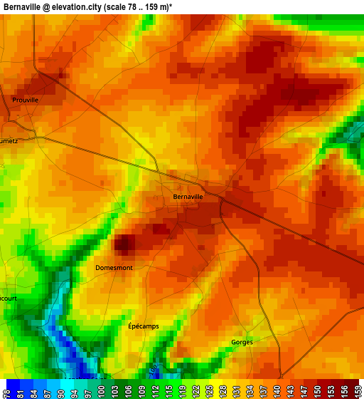
Below is the Elevation map of Bernaville, which displays elevation range with different colors. Scale of the first map is from 78 to 159 m (256 to 522 ft) with average elevation of 134.7 meters (=442 ft) [note 1]
These maps also provides idea of topography and contour of this city, they are displayed at different zoom levels. More info about maps, scale and edge coordinates you can find below images.
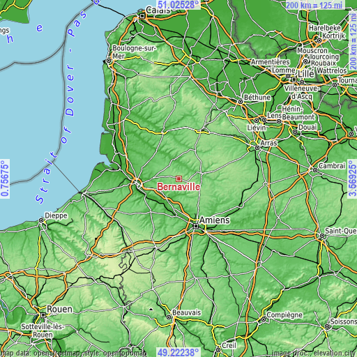
| \ | Map #1 | Topo.Map |
| Scale [m] | 78..159 m | × |
| Scale [ft] | 256..522 ft | × |
| Average | 134.7 m = 442 ft | × |
| Width | 6.26 km = 3.9 mi | 200.5 km = 124.6 mi |
| Height | 6.26 km = 3.9 mi | 200.4 km = 124.5 mi |
| ↑Max Latitude | 50.160481° | 51.02528° |
| Latitude at center | 50.13232° | 50.13232° |
| ↓Min Latitude | 50.104142° | 49.22238° |
| ← Min Longitude | 2.119055° | 0.75675° |
| Longitude center | 2.163° | 2.163° |
| →Max Longitude | 2.206945° | 3.56925° |
Nearby cities:
Cities around Bernaville sort by population:
• Doullens elevation 60 m
12.9 km,  77°
77°
• Flixecourt 18 m
14.3 km,  204°
204°
• Auxi-le-Château 32 m
11.5 km,  343°
343°
• Beauval 106 m
12.4 km,  102°
102°
• Saint-Ouen 25 m
10.9 km, 196°
• Vignacourt 126 m
13.6 km,  169°
169°
• Flesselles 127 m
16.1 km,  154°
154°
• Saint-Léger-lès-Domart 31 m
9.1 km,  190°
190°
• Saint-Riquier 27 m
15.4 km,  270°
270°
• Domart-en-Ponthieu 56 m
7 km, 202°
• Naours 70 m
13.4 km,  142°
142°
• Berteaucourt-les-Dames 42 m
9.5 km,  182°
182°
Multilingual:
 En español:
Bernaville elevación 140 m.
 En France:
Bernaville élévation 140 m.
 Auf Deutsch:
Bernaville höhe über dem Meeresspiegel ist 140 m.

Sources and notes:
- [note 1] Map square and city borders are not equal. Map elevation data is calculated only from area inside that square.
- [src 1] Elevation data from geonames database provided with same terms of usage.
- [src 2] The elevation map of Bernaville is generated using elevation data from NASA's 3 arcsec (90m) resolution SRTM data.
- [src 3] Base (background) map © OpenStreetMap contributors tiles are generated by Geofabrik and OpenTopoMap.
Copyright & License:
This Bernaville Elevation Map is licensed under CC BY-SA. You may reuse any part from this page, if you give a proper credit by linking to this URL:
 More info on terms of use page.