Bernay elevation
Bernay (Normandy, Département de l'Eure), France elevation is 113 meters and Bernay elevation in feet is 371 ft above sea level [src 1]. Bernay is a seat of a third-order administrative division (feature code) with elevation that is 61 meters (200 ft) smaller than average city elevation in France.
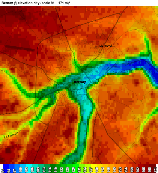
Below is the Elevation map of Bernay, which displays elevation range with different colors. Scale of the first map is from 91 to 171 m (299 to 561 ft) with average elevation of 148.8 meters (=488 ft) [note 1]
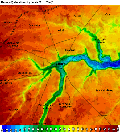
These maps also provides idea of topography and contour of this city, they are displayed at different zoom levels. More info about maps, scale and edge coordinates you can find below images.
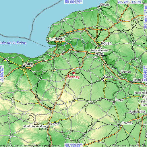
| \ | Map #1 | Map #2 | Topo.Map |
| Scale [m] | 91..171 m | 82..185 m | × |
| Scale [ft] | 299..561 ft | 269..607 ft | × |
| Average | 148.8 m = 488 ft | 156.6 m = 514 ft | × |
| Width | 6.4 km = 4 mi | 12.8 km = 8 mi | 204.8 km = 127.3 mi |
| Height | 6.4 km = 4 mi | 12.8 km = 8 mi | 204.8 km = 127.3 mi |
| ↑Max Latitude | 49.117651° | 49.146405° | 50.00129° |
| Latitude at center | 49.08888° | 49.08888° | 49.08888° |
| ↓Min Latitude | 49.060092° | 49.031288° | 48.15939° |
| ← Min Longitude | 0.554635° | 0.510689° | -0.80767° |
| Longitude center | 0.59858° | 0.59858° | 0.59858° |
| →Max Longitude | 0.642525° | 0.686471° | 2.00483° |
Nearby cities:
Cities around Bernay sort by population:
• Brionne elevation 58 m
14.6 km,  35°
35°
• Le Neubourg 139 m
23.7 km,  73°
73°
• Beaumont-le-Roger 90 m
13.3 km,  95°
95°
• Orbec 149 m
15.5 km,  238°
238°
• Serquigny 81 m
8.4 km, 74°
• Thiberville 171 m
11.8 km,  297°
297°
• Nassandres 73 m
10.8 km, 67°
• Menneval 152 m
1.8 km,  46°
46°
• Moyaux 158 m
21.2 km, 303°
• Lieurey 171 m
17.3 km,  335°
335°
• Broglie 148 m
10.2 km,  209°
209°
• La Vespière 129 m
15.6 km, 240°
Multilingual:
 En español:
Bernay elevación 113 m.
 En France:
Bernay élévation 113 m.


Sources and notes:
- [note 1] Map square and city borders are not equal. Map elevation data is calculated only from area inside that square.
- [src 1] Elevation data from geonames database provided with same terms of usage.
- [src 2] The elevation map of Bernay is generated using elevation data from NASA's 3 arcsec (90m) resolution SRTM data.
- [src 3] Base (background) map © OpenStreetMap contributors tiles are generated by Geofabrik and OpenTopoMap.
Copyright & License:
This Bernay Elevation Map is licensed under CC BY-SA. You may reuse any part from this page, if you give a proper credit by linking to this URL:
 More info on terms of use page.