Béziers elevation
Béziers (Occitanie, Département de l'Hérault), France elevation is 66 meters and Béziers elevation in feet is 217 ft above sea level [src 1]. Béziers is a seat of a third-order administrative division (feature code) with elevation that is 108 meters (354 ft) smaller than average city elevation in France.
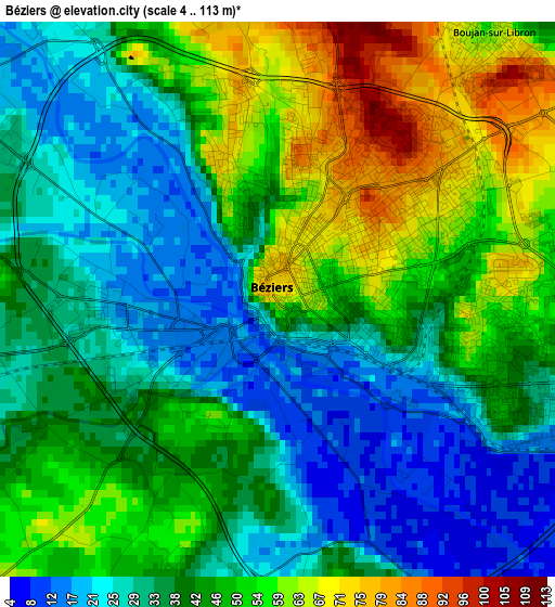
Below is the Elevation map of Béziers, which displays elevation range with different colors. Scale of the first map is from 4 to 113 m (13 to 371 ft) with average elevation of 41.5 meters (=136 ft) [note 1]
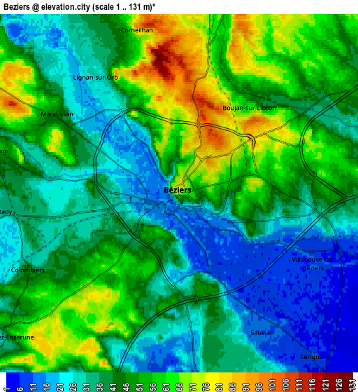
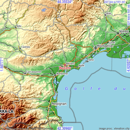
These maps also provides idea of topography and contour of this city, they are displayed at different zoom levels. More info about maps, scale and edge coordinates you can find below images.
| \ | Map #1 | Map #2 | Topo.Map |
| Scale [m] | 4..113 m | 1..131 m | × |
| Scale [ft] | 13..371 ft | 3..430 ft | × |
| Average | 41.5 m = 136 ft | 42.7 m = 140 ft | × |
| Width | 7.11 km = 4.4 mi | 14.21 km = 8.8 mi | 227.4 km = 141.3 mi |
| Height | 7.11 km = 4.4 mi | 14.21 km = 8.8 mi | 227.4 km = 141.3 mi |
| ↑Max Latitude | 43.373172° | 43.405107° | 44.35534° |
| Latitude at center | 43.34122° | 43.34122° | 43.34122° |
| ↓Min Latitude | 43.309251° | 43.277265° | 42.30988° |
| ← Min Longitude | 3.170075° | 3.126129° | 1.80777° |
| Longitude center | 3.21402° | 3.21402° | 3.21402° |
| →Max Longitude | 3.257965° | 3.301911° | 4.62027° |
Nearby cities:
Cities around Béziers sort by population:
• Sauvian elevation 9 m
6.5 km,  145°
145°
• Villeneuve-lès-Béziers 13 m
6.1 km,  118°
118°
• Lignan-sur-Orb 26 m
6 km,  322°
322°
• Maraussan 46 m
5.6 km,  303°
303°
• Boujan-sur-Libron 64 m
4.2 km,  40°
40°
• Lespignan 32 m
8.2 km,  204°
204°
• Montady 34 m
7 km,  265°
265°
• Colombiers 45 m
6.7 km,  243°
243°
• Cers 12 m
7.6 km,  105°
105°
• Corneilhan 82 m
6.7 km,  344°
344°
• Vendres 14 m
8 km,  174°
174°
• Maureilhan 51 m
7.9 km,  277°
277°
Multilingual:
 En español:
Béziers elevación 66 m.
 En France:
Béziers élévation 66 m.


Sources and notes:
- [note 1] Map square and city borders are not equal. Map elevation data is calculated only from area inside that square.
- [src 1] Elevation data from geonames database provided with same terms of usage.
- [src 2] The elevation map of Béziers is generated using elevation data from NASA's 3 arcsec (90m) resolution SRTM data.
- [src 3] Base (background) map © OpenStreetMap contributors tiles are generated by Geofabrik and OpenTopoMap.
Copyright & License:
This Béziers Elevation Map is licensed under CC BY-SA. You may reuse any part from this page, if you give a proper credit by linking to this URL:
 More info on terms of use page.