Boissy-Saint-Léger elevation
Boissy-Saint-Léger (Île-de-France, Val-de-Marne), France elevation is 89 meters and Boissy-Saint-Léger elevation in feet is 292 ft above sea level [src 1]. Boissy-Saint-Léger is a populated place (feature code) with elevation that is 85 meters (279 ft) smaller than average city elevation in France.
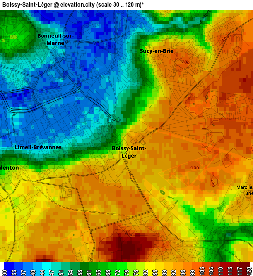
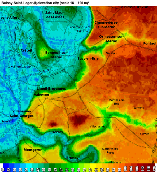
Below is the Elevation map of Boissy-Saint-Léger, which displays elevation range with different colors. Scale of the first map is from 30 to 120 m (98 to 394 ft) with average elevation of 76.1 meters (=250 ft) [note 1]
These maps also provides idea of topography and contour of this city, they are displayed at different zoom levels. More info about maps, scale and edge coordinates you can find below images.
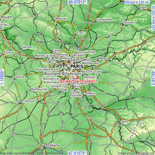
| \ | Map #1 | Map #2 | Topo.Map |
| Scale [m] | 30..120 m | 18..120 m | × |
| Scale [ft] | 98..394 ft | 59..394 ft | × |
| Average | 76.1 m = 250 ft | 70.3 m = 231 ft | × |
| Width | 6.44 km = 4 mi | 12.89 km = 8 mi | 206.2 km = 128.1 mi |
| Height | 6.44 km = 4 mi | 12.89 km = 8 mi | 206.2 km = 128.1 mi |
| ↑Max Latitude | 48.780456° | 48.809405° | 49.67013° |
| Latitude at center | 48.75149° | 48.75149° | 48.75149° |
| ↓Min Latitude | 48.722507° | 48.693508° | 47.81575° |
| ← Min Longitude | 2.467685° | 2.423739° | 1.10538° |
| Longitude center | 2.51163° | 2.51163° | 2.51163° |
| →Max Longitude | 2.555575° | 2.599521° | 3.91788° |
Nearby cities:
Cities around Boissy-Saint-Léger sort by population:
• Saint-Maur-des-Fossés elevation 38 m
4.9 km,  344°
344°
• Villeneuve-Saint-Georges 35 m
5.1 km,  244°
244°
• Yerres 73 m
4 km,  199°
199°
• Sucy-en-Brie 97 m
2.6 km,  41°
41°
• Limeil-Brévannes 67 m
1.9 km,  247°
247°
• Bonneuil-sur-Marne 48 m
3.1 km,  310°
310°
• Valenton 52 m
3.5 km,  258°
258°
• Ormesson-sur-Marne 97 m
4.6 km,  32°
32°
• Villecresnes 64 m
4 km,  149°
149°
• Crosne 39 m
5.4 km,  227°
227°
• Noiseau 100 m
3.9 km,  45°
45°
• Santeny 93 m
5.3 km,  120°
120°
Multilingual:
 En español:
Boissy-Saint-Léger elevación 89 m.
 En France:
Boissy-Saint-Léger élévation 89 m.
 Auf Deutsch:
Boissy-Saint-Léger höhe über dem Meeresspiegel ist 89 m.

Sources and notes:
- [note 1] Map square and city borders are not equal. Map elevation data is calculated only from area inside that square.
- [src 1] Elevation data from geonames database provided with same terms of usage.
- [src 2] The elevation map of Boissy-Saint-Léger is generated using elevation data from NASA's 3 arcsec (90m) resolution SRTM data.
- [src 3] Base (background) map © OpenStreetMap contributors tiles are generated by Geofabrik and OpenTopoMap.
Copyright & License:
This Boissy-Saint-Léger Elevation Map is licensed under CC BY-SA. You may reuse any part from this page, if you give a proper credit by linking to this URL:
 More info on terms of use page.