Bourges elevation
Bourges (Centre, Cher), France elevation is 144 meters and Bourges elevation in feet is 472 ft above sea level [src 1]. Bourges is a seat of a second-order administrative division (feature code) with elevation that is 30 meters (98 ft) smaller than average city elevation in France.
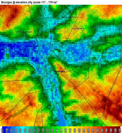
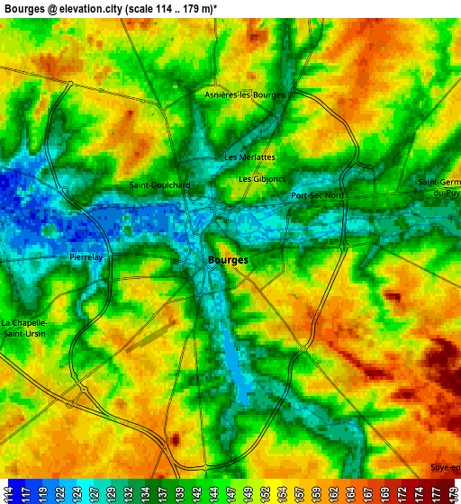
Below is the Elevation map of Bourges, which displays elevation range with different colors. Scale of the first map is from 117 to 170 m (384 to 558 ft) with average elevation of 140.9 meters (=462 ft) [note 1]
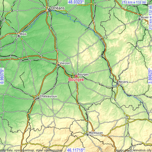
These maps also provides idea of topography and contour of this city, they are displayed at different zoom levels. More info about maps, scale and edge coordinates you can find below images.
| \ | Map #1 | Map #2 | Topo.Map |
| Scale [m] | 117..170 m | 114..179 m | × |
| Scale [ft] | 384..558 ft | 374..587 ft | × |
| Average | 140.9 m = 462 ft | 145.5 m = 477 ft | × |
| Width | 6.65 km = 4.1 mi | 13.31 km = 8.3 mi | 212.9 km = 132.3 mi |
| Height | 6.65 km = 4.1 mi | 13.31 km = 8.3 mi | 212.9 km = 132.3 mi |
| ↑Max Latitude | 47.113245° | 47.143144° | 48.0323° |
| Latitude at center | 47.08333° | 47.08333° | 47.08333° |
| ↓Min Latitude | 47.053398° | 47.023449° | 46.11715° |
| ← Min Longitude | 2.356055° | 2.312109° | 0.99375° |
| Longitude center | 2.4° | 2.4° | 2.4° |
| →Max Longitude | 2.443945° | 2.487891° | 3.80625° |
Nearby cities:
Cities around Bourges sort by population:
• Saint-Doulchard elevation 138 m
4.3 km,  301°
301°
• Saint-Florent-sur-Cher 145 m
14.9 km,  229°
229°
• Saint-Germain-du-Puy 151 m
6.6 km,  73°
73°
• La Chapelle-Saint-Ursin 149 m
6.2 km,  247°
247°
• Trouy 165 m
8.5 km,  200°
200°
• Saint-Martin-d’Auxigny 161 m
13.4 km,  5°
5°
• Fussy 155 m
7.1 km,  18°
18°
• Marmagne 121 m
9 km,  281°
281°
• Plaimpied-Givaudins 152 m
10.3 km,  156°
156°
• Saint-Éloy-de-Gy 157 m
9.1 km,  331°
331°
• Sainte-Solange 154 m
12.8 km,  62°
62°
• Vasselay 171 m
8.2 km,  354°
354°
Multilingual:
 En español:
Bourges elevación 144 m.
 En France:
Bourges élévation 144 m.


Sources and notes:
- [note 1] Map square and city borders are not equal. Map elevation data is calculated only from area inside that square.
- [src 1] Elevation data from geonames database provided with same terms of usage.
- [src 2] The elevation map of Bourges is generated using elevation data from NASA's 3 arcsec (90m) resolution SRTM data.
- [src 3] Base (background) map © OpenStreetMap contributors tiles are generated by Geofabrik and OpenTopoMap.
Copyright & License:
This Bourges Elevation Map is licensed under CC BY-SA. You may reuse any part from this page, if you give a proper credit by linking to this URL:
 More info on terms of use page.