Boussy-Saint-Antoine elevation
Boussy-Saint-Antoine (Île-de-France, Département de l'Essonne), France elevation is 58 meters and Boussy-Saint-Antoine elevation in feet is 190 ft above sea level [src 1]. Boussy-Saint-Antoine is a populated place (feature code) with elevation that is 116 meters (381 ft) smaller than average city elevation in France.
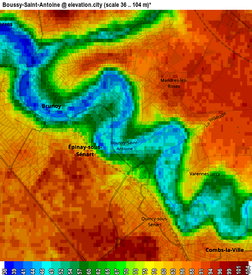
Below is the Elevation map of Boussy-Saint-Antoine, which displays elevation range with different colors. Scale of the first map is from 36 to 104 m (118 to 341 ft) with average elevation of 77.3 meters (=254 ft) [note 1]
These maps also provides idea of topography and contour of this city, they are displayed at different zoom levels. More info about maps, scale and edge coordinates you can find below images.
| \ | Map #1 | Map #2 | Topo.Map |
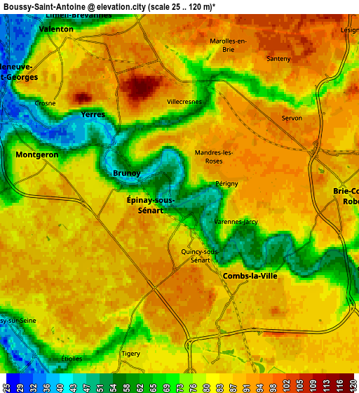
| Scale [m] | 36..104 m | 25..120 m | × |
| Scale [ft] | 118..341 ft | 82..394 ft | × |
| Average | 77.3 m = 254 ft | 81 m = 266 ft | × |
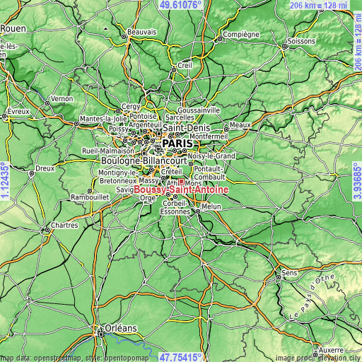
| Width | 6.45 km = 4 mi | 12.9 km = 8 mi | 206.4 km = 128.3 mi |
| Height | 6.45 km = 4 mi | 12.9 km = 8 mi | 206.4 km = 128.3 mi |
| ↑Max Latitude | 48.720011° | 48.748995° | 49.61076° |
| Latitude at center | 48.69101° | 48.69101° | 48.69101° |
| ↓Min Latitude | 48.661992° | 48.632958° | 47.75415° |
| ← Min Longitude | 2.486655° | 2.442709° | 1.12435° |
| Longitude center | 2.5306° | 2.5306° | 2.5306° |
| →Max Longitude | 2.574545° | 2.618491° | 3.93685° |
Nearby cities:
Cities around Boussy-Saint-Antoine sort by population:
• Yerres elevation 73 m
4 km,  317°
317°
• Brunoy 81 m
2.8 km,  277°
277°
• Combs-la-Ville 81 m
4.1 km,  135°
135°
• Épinay-sous-Sénart 80 m
1.4 km,  263°
263°
• Villecresnes 64 m
3.3 km,  11°
11°
• Quincy-sous-Sénart 85 m
2 km,  172°
172°
• Mandres-les-Roses 94 m
1.7 km,  43°
43°
• Santeny 93 m
5.1 km, 37°
• Servon 89 m
5 km,  55°
55°
• Périgny 93 m
1.9 km,  71°
71°
• Varennes-Jarcy 57 m
2.6 km,  120°
120°
• Tigery 76 m
5.6 km,  197°
197°
Multilingual:
 En español:
Boussy-Saint-Antoine elevación 58 m.
 En France:
Boussy-Saint-Antoine élévation 58 m.
 Auf Deutsch:
Boussy-Saint-Antoine höhe über dem Meeresspiegel ist 58 m.
 На русском:
Boussy-Saint-Antoine высота над уровнем моря 58 м
Sources and notes:
- [note 1] Map square and city borders are not equal. Map elevation data is calculated only from area inside that square.
- [src 1] Elevation data from geonames database provided with same terms of usage.
- [src 2] The elevation map of Boussy-Saint-Antoine is generated using elevation data from NASA's 3 arcsec (90m) resolution SRTM data.
- [src 3] Base (background) map © OpenStreetMap contributors tiles are generated by Geofabrik and OpenTopoMap.
Copyright & License:
This Boussy-Saint-Antoine Elevation Map is licensed under CC BY-SA. You may reuse any part from this page, if you give a proper credit by linking to this URL:
 More info on terms of use page.