Brumath elevation
Brumath (Grand Est, Bas-Rhin), France elevation is 156 meters and Brumath elevation in feet is 512 ft above sea level [src 1]. Brumath is a populated place (feature code) with elevation that is 18 meters (59 ft) smaller than average city elevation in France.
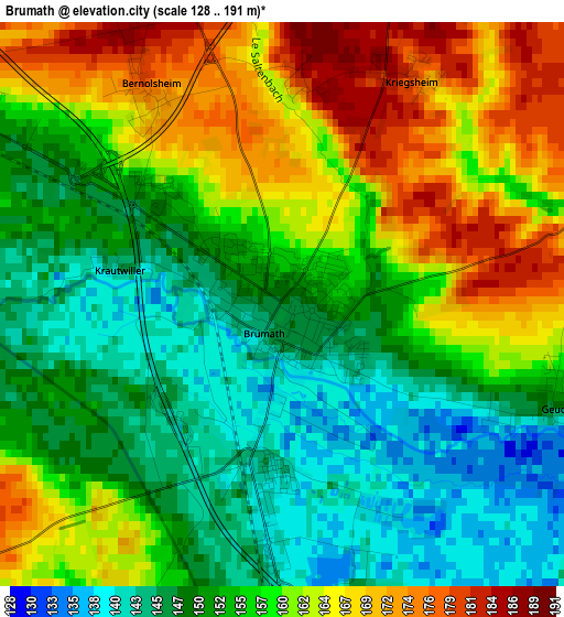
Below is the Elevation map of Brumath, which displays elevation range with different colors. Scale of the first map is from 128 to 191 m (420 to 627 ft) with average elevation of 156.2 meters (=512 ft) [note 1]
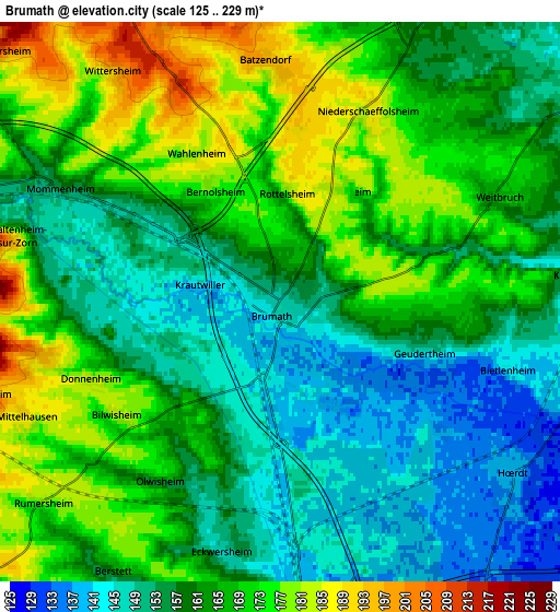
These maps also provides idea of topography and contour of this city, they are displayed at different zoom levels. More info about maps, scale and edge coordinates you can find below images.
| \ | Map #1 | Map #2 | Topo.Map |
| Scale [m] | 128..191 m | 125..229 m | × |
| Scale [ft] | 420..627 ft | 410..751 ft | × |
| Average | 156.2 m = 512 ft | 162 m = 531 ft | × |
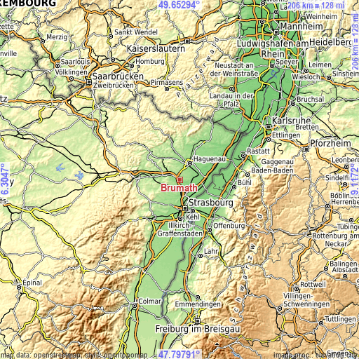
| Width | 6.45 km = 4 mi | 12.89 km = 8 mi | 206.3 km = 128.2 mi |
| Height | 6.45 km = 4 mi | 12.89 km = 8 mi | 206.2 km = 128.1 mi |
| ↑Max Latitude | 48.762956° | 48.791915° | 49.65294° |
| Latitude at center | 48.73398° | 48.73398° | 48.73398° |
| ↓Min Latitude | 48.704987° | 48.675978° | 47.79791° |
| ← Min Longitude | 7.667005° | 7.623059° | 6.3047° |
| Longitude center | 7.71095° | 7.71095° | 7.71095° |
| →Max Longitude | 7.754895° | 7.798841° | 9.1172° |
Nearby cities:
Cities around Brumath sort by population:
• Vendenheim elevation 150 m
7.2 km,  180°
180°
• Hœrdt 138 m
6.5 km,  125°
125°
• Weyersheim 141 m
6.9 km,  106°
106°
• Gries 143 m
7.9 km,  73°
73°
• Weitbruch 163 m
5.5 km, 65°
• Geudertheim 150 m
3.2 km, 110°
• Berstett 165 m
7.3 km,  212°
212°
• Mommenheim 155 m
5.5 km,  298°
298°
• Schwindratzheim 160 m
8.6 km,  286°
286°
• Niederschaeffolsheim 184 m
4.7 km,  25°
25°
• Eckwersheim 150 m
5.9 km,  190°
190°
• Wingersheim 193 m
5.8 km,  256°
256°
Multilingual:
 En español:
Brumath elevación 156 m.
 En France:
Brumath élévation 156 m.


Sources and notes:
- [note 1] Map square and city borders are not equal. Map elevation data is calculated only from area inside that square.
- [src 1] Elevation data from geonames database provided with same terms of usage.
- [src 2] The elevation map of Brumath is generated using elevation data from NASA's 3 arcsec (90m) resolution SRTM data.
- [src 3] Base (background) map © OpenStreetMap contributors tiles are generated by Geofabrik and OpenTopoMap.
Copyright & License:
This Brumath Elevation Map is licensed under CC BY-SA. You may reuse any part from this page, if you give a proper credit by linking to this URL:
 More info on terms of use page.