Bruyères elevation
Bruyères (Grand Est, Vosges), France elevation is 477 meters and Bruyères elevation in feet is 1565 ft above sea level [src 1]. Bruyères is a populated place (feature code) with elevation that is 303 meters (994 ft) bigger than average city elevation in France.
Below is the Elevation map of Bruyères, which displays elevation range with different colors. Scale of the first map is from 372 to 705 m (1220 to 2313 ft) with average elevation of 457.1 meters (=1500 ft) [note 1]
These maps also provides idea of topography and contour of this city, they are displayed at different zoom levels. More info about maps, scale and edge coordinates you can find below images.
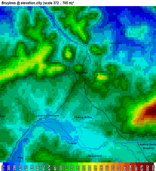
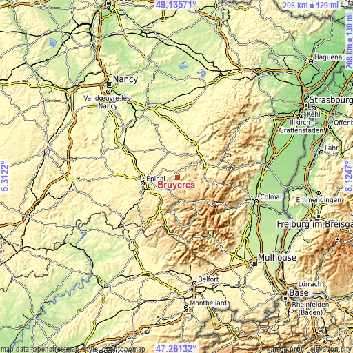
| \ | Map #1 | Topo.Map |
| Scale [m] | 372..705 m | × |
| Scale [ft] | 1220..2313 ft | × |
| Average | 457.1 m = 1500 ft | × |
| Width | 6.51 km = 4 mi | 208.4 km = 129.5 mi |
| Height | 6.51 km = 4 mi | 208.4 km = 129.5 mi |
| ↑Max Latitude | 48.236369° | 49.13571° |
| Latitude at center | 48.20709° | 48.20709° |
| ↓Min Latitude | 48.177795° | 47.26132° |
| ← Min Longitude | 6.674505° | 5.3122° |
| Longitude center | 6.71845° | 6.71845° |
| →Max Longitude | 6.762395° | 8.1247° |
Nearby cities:
Cities around Bruyères sort by population:
• Rambervillers elevation 284 m
16.2 km,  337°
337°
• Éloyes 380 m
14.7 km,  214°
214°
• Granges-sur-Vologne 498 m
8.7 km,  142°
142°
• Pouxeux 370 m
15.6 km,  223°
223°
• Corcieux 538 m
12.7 km,  107°
107°
• Le Tholy 595 m
14 km,  172°
172°
• Deyvillers 343 m
15.1 km,  267°
267°
• Taintrux 373 m
14.2 km,  70°
70°
• Cheniménil 374 m
11.4 km,  228°
228°
• Jeanménil 332 m
14.5 km,  350°
350°
• Aydoilles 378 m
10.7 km, 271°
• Docelles 374 m
10.5 km, 228°
Multilingual:
 En español:
Bruyères elevación 477 m.
 En France:
Bruyères élévation 477 m.
 Auf Deutsch:
Bruyères höhe über dem Meeresspiegel ist 477 m.

Sources and notes:
- [note 1] Map square and city borders are not equal. Map elevation data is calculated only from area inside that square.
- [src 1] Elevation data from geonames database provided with same terms of usage.
- [src 2] The elevation map of Bruyères is generated using elevation data from NASA's 3 arcsec (90m) resolution SRTM data.
- [src 3] Base (background) map © OpenStreetMap contributors tiles are generated by Geofabrik and OpenTopoMap.
Copyright & License:
This Bruyères Elevation Map is licensed under CC BY-SA. You may reuse any part from this page, if you give a proper credit by linking to this URL:
 More info on terms of use page.