Castelginest elevation
Castelginest (Occitanie, Haute-Garonne), France elevation is 131 meters and Castelginest elevation in feet is 430 ft above sea level [src 1]. Castelginest is a populated place (feature code) with elevation that is 43 meters (141 ft) smaller than average city elevation in France.
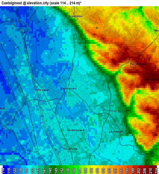
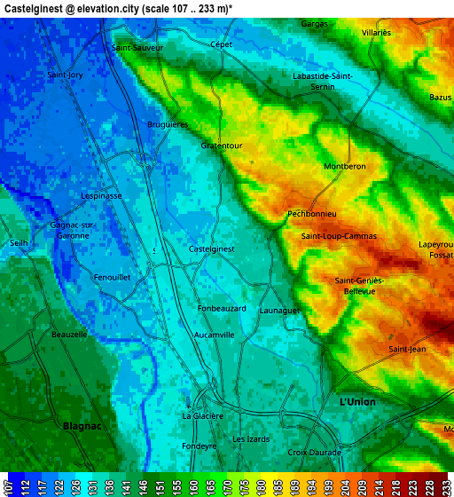
Below is the Elevation map of Castelginest, which displays elevation range with different colors. Scale of the first map is from 114 to 214 m (374 to 702 ft) with average elevation of 145.9 meters (=479 ft) [note 1]
These maps also provides idea of topography and contour of this city, they are displayed at different zoom levels. More info about maps, scale and edge coordinates you can find below images.
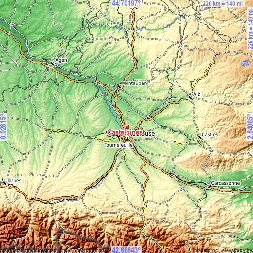
| \ | Map #1 | Map #2 | Topo.Map |
| Scale [m] | 114..214 m | 107..233 m | × |
| Scale [ft] | 374..702 ft | 351..764 ft | × |
| Average | 145.9 m = 479 ft | 146.7 m = 481 ft | × |
| Width | 7.07 km = 4.4 mi | 14.13 km = 8.8 mi | 226.1 km = 140.5 mi |
| Height | 7.07 km = 4.4 mi | 14.13 km = 8.8 mi | 226.1 km = 140.5 mi |
| ↑Max Latitude | 43.725586° | 43.757335° | 44.70197° |
| Latitude at center | 43.69382° | 43.69382° | 43.69382° |
| ↓Min Latitude | 43.662037° | 43.630238° | 42.66843° |
| ← Min Longitude | 1.390455° | 1.346509° | 0.02815° |
| Longitude center | 1.4344° | 1.4344° | 1.4344° |
| →Max Longitude | 1.478345° | 1.522291° | 2.84065° |
Nearby cities:
Cities around Castelginest sort by population:
• Aucamville elevation 133 m
2.7 km,  190°
190°
• Launaguet 137 m
2.5 km,  134°
134°
• Saint-Alban 129 m
1.9 km,  266°
266°
• Fenouillet 129 m
3.7 km,  246°
246°
• Bruguières 120 m
4.3 km,  329°
329°
• Gratentour 176 m
3.3 km,  357°
357°
• Pechbonnieu 194 m
2.7 km,  68°
68°
• Fonbeauzard 132 m
1.7 km,  180°
180°
• Montberon 182 m
4.4 km,  56°
56°
• Lespinasse 122 m
4.5 km,  296°
296°
• Saint-Geniès-Bellevue 207 m
4.4 km,  104°
104°
• Saint-Loup-Cammas 211 m
3.8 km,  83°
83°
Multilingual:
 En español:
Castelginest elevación 131 m.
 En France:
Castelginest élévation 131 m.
 Auf Deutsch:
Castelginest höhe über dem Meeresspiegel ist 131 m.

Sources and notes:
- [note 1] Map square and city borders are not equal. Map elevation data is calculated only from area inside that square.
- [src 1] Elevation data from geonames database provided with same terms of usage.
- [src 2] The elevation map of Castelginest is generated using elevation data from NASA's 3 arcsec (90m) resolution SRTM data.
- [src 3] Base (background) map © OpenStreetMap contributors tiles are generated by Geofabrik and OpenTopoMap.
Copyright & License:
This Castelginest Elevation Map is licensed under CC BY-SA. You may reuse any part from this page, if you give a proper credit by linking to this URL:
 More info on terms of use page.