Castelmoron-sur-Lot elevation
Castelmoron-sur-Lot (Nouvelle-Aquitaine, Département du Lot-et-Garonne), France elevation is 41 meters and Castelmoron-sur-Lot elevation in feet is 135 ft above sea level [src 1]. Castelmoron-sur-Lot is a populated place (feature code) with elevation that is 133 meters (436 ft) smaller than average city elevation in France.
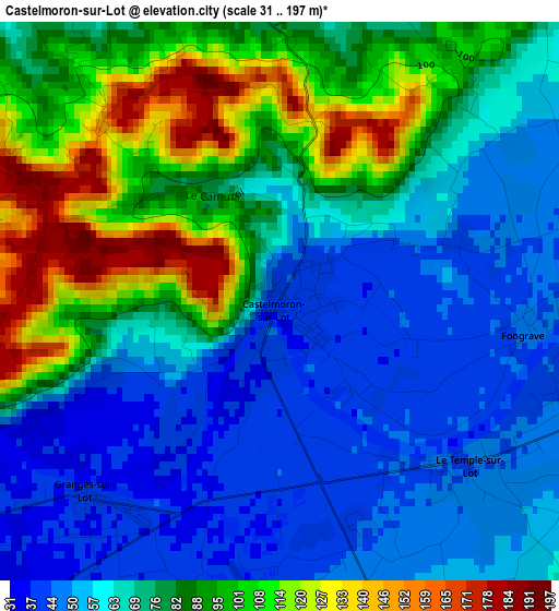
Below is the Elevation map of Castelmoron-sur-Lot, which displays elevation range with different colors. Scale of the first map is from 31 to 197 m (102 to 646 ft) with average elevation of 75.2 meters (=247 ft) [note 1]
These maps also provides idea of topography and contour of this city, they are displayed at different zoom levels. More info about maps, scale and edge coordinates you can find below images.
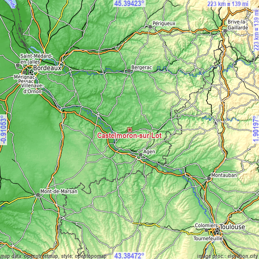
| \ | Map #1 | Topo.Map |
| Scale [m] | 31..197 m | × |
| Scale [ft] | 102..646 ft | × |
| Average | 75.2 m = 247 ft | × |
| Width | 6.98 km = 4.3 mi | 223.4 km = 138.8 mi |
| Height | 6.98 km = 4.3 mi | 223.4 km = 138.8 mi |
| ↑Max Latitude | 44.42949° | 45.39423° |
| Latitude at center | 44.3981° | 44.3981° |
| ↓Min Latitude | 44.366693° | 43.38472° |
| ← Min Longitude | 0.451775° | -0.91053° |
| Longitude center | 0.49572° | 0.49572° |
| →Max Longitude | 0.539665° | 1.90197° |
Nearby cities:
Cities around Castelmoron-sur-Lot sort by population:
• Villeneuve-sur-Lot elevation 56 m
16.6 km,  85°
85°
• Tonneins 42 m
14.6 km,  267°
267°
• Sainte-Livrade-sur-Lot 53 m
7.6 km, 89°
• Aiguillon 45 m
16.6 km,  228°
228°
• Pujols 68 m
15.3 km, 91°
• Bias 57 m
14 km,  81°
81°
• Colayrac-Saint-Cirq 41 m
20.2 km,  167°
167°
• Clairac 55 m
10.2 km,  245°
245°
• Casseneuil 52 m
11.1 km,  63°
63°
• Port-Sainte-Marie 55 m
18.3 km,  207°
207°
• Gontaud-de-Nogaret 61 m
16.6 km,  290°
290°
• Cancon 166 m
18.4 km,  33°
33°
Multilingual:
 En español:
Castelmoron-sur-Lot elevación 41 m.
 En France:
Castelmoron-sur-Lot élévation 41 m.
 Auf Deutsch:
Castelmoron-sur-Lot höhe über dem Meeresspiegel ist 41 m.
 На русском:
Castelmoron-sur-Lot высота над уровнем моря 41 м
Sources and notes:
- [note 1] Map square and city borders are not equal. Map elevation data is calculated only from area inside that square.
- [src 1] Elevation data from geonames database provided with same terms of usage.
- [src 2] The elevation map of Castelmoron-sur-Lot is generated using elevation data from NASA's 3 arcsec (90m) resolution SRTM data.
- [src 3] Base (background) map © OpenStreetMap contributors tiles are generated by Geofabrik and OpenTopoMap.
Copyright & License:
This Castelmoron-sur-Lot Elevation Map is licensed under CC BY-SA. You may reuse any part from this page, if you give a proper credit by linking to this URL:
 More info on terms of use page.