Caussade elevation
Caussade (Occitanie, Département du Tarn-et-Garonne), France elevation is 118 meters and Caussade elevation in feet is 387 ft above sea level [src 1]. Caussade is a populated place (feature code) with elevation that is 56 meters (184 ft) smaller than average city elevation in France.
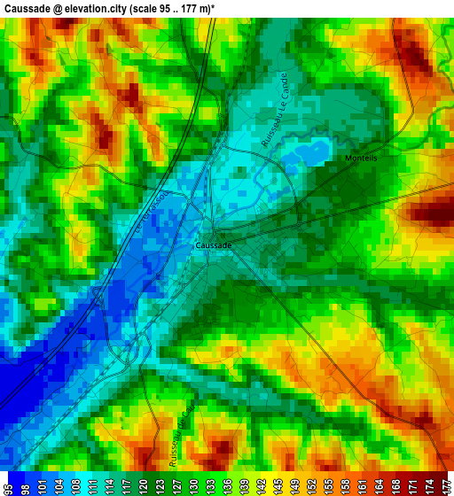
Below is the Elevation map of Caussade, which displays elevation range with different colors. Scale of the first map is from 95 to 177 m (312 to 581 ft) with average elevation of 129.4 meters (=425 ft) [note 1]
These maps also provides idea of topography and contour of this city, they are displayed at different zoom levels. More info about maps, scale and edge coordinates you can find below images.
| \ | Map #1 | Map #2 | Topo.Map |
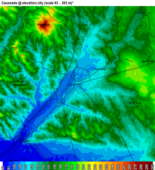
| Scale [m] | 95..177 m | 83..303 m | × |
| Scale [ft] | 312..581 ft | 272..994 ft | × |
| Average | 129.4 m = 425 ft | 142.5 m = 468 ft | × |
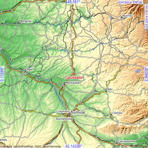
| Width | 7.01 km = 4.4 mi | 14.02 km = 8.7 mi | 224.3 km = 139.4 mi |
| Height | 7.01 km = 4.4 mi | 14.02 km = 8.7 mi | 224.3 km = 139.4 mi |
| ↑Max Latitude | 44.192317° | 44.223818° | 45.161° |
| Latitude at center | 44.1608° | 44.1608° | 44.1608° |
| ↓Min Latitude | 44.129266° | 44.097715° | 43.14335° |
| ← Min Longitude | 1.495185° | 1.451239° | 0.13288° |
| Longitude center | 1.53913° | 1.53913° | 1.53913° |
| →Max Longitude | 1.583075° | 1.627021° | 2.94538° |
Nearby cities:
Cities around Caussade sort by population:
• Nègrepelisse elevation 104 m
9.7 km,  189°
189°
• Saint-Etienne-de-Tulmont 111 m
13.6 km,  205°
205°
• Albias 91 m
10.7 km,  222°
222°
• Septfonds 176 m
6.6 km,  72°
72°
• Castelnau-Montratier 194 m
18.1 km,  310°
310°
• Réalville 108 m
7 km, 222°
• Caylus 231 m
20.3 km, 65°
• Montpezat-de-Quercy 264 m
10 km,  330°
330°
• Monteils 149 m
3.1 km, 73°
• Lalbenque 277 m
19.9 km,  1°
1°
• Molières 175 m
14.5 km,  284°
284°
• Montricoux 121 m
11.4 km,  145°
145°
Multilingual:
 En español:
Caussade elevación 118 m.
 En France:
Caussade élévation 118 m.
 Auf Deutsch:
Caussade höhe über dem Meeresspiegel ist 118 m.

Sources and notes:
- [note 1] Map square and city borders are not equal. Map elevation data is calculated only from area inside that square.
- [src 1] Elevation data from geonames database provided with same terms of usage.
- [src 2] The elevation map of Caussade is generated using elevation data from NASA's 3 arcsec (90m) resolution SRTM data.
- [src 3] Base (background) map © OpenStreetMap contributors tiles are generated by Geofabrik and OpenTopoMap.
Copyright & License:
This Caussade Elevation Map is licensed under CC BY-SA. You may reuse any part from this page, if you give a proper credit by linking to this URL:
 More info on terms of use page.