Ceaucé elevation
Ceaucé (Normandy, Département de l'Orne), France elevation is 142 meters and Ceaucé elevation in feet is 466 ft above sea level [src 1]. Ceaucé is a populated place (feature code) with elevation that is 32 meters (105 ft) smaller than average city elevation in France.
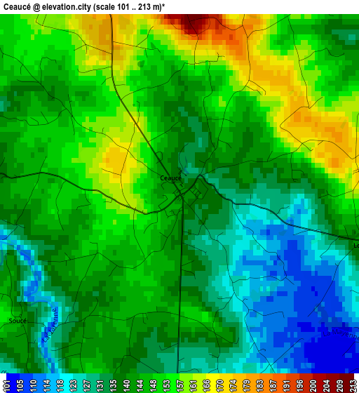
Below is the Elevation map of Ceaucé, which displays elevation range with different colors. Scale of the first map is from 101 to 213 m (331 to 699 ft) with average elevation of 143.3 meters (=470 ft) [note 1]
These maps also provides idea of topography and contour of this city, they are displayed at different zoom levels. More info about maps, scale and edge coordinates you can find below images.
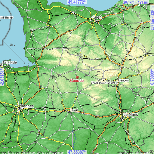
| \ | Map #1 | Topo.Map |
| Scale [m] | 101..213 m | × |
| Scale [ft] | 331..699 ft | × |
| Average | 143.3 m = 470 ft | × |
| Width | 6.48 km = 4 mi | 207.2 km = 128.7 mi |
| Height | 6.48 km = 4 mi | 207.2 km = 128.7 mi |
| ↑Max Latitude | 48.523474° | 49.41772° |
| Latitude at center | 48.49436° | 48.49436° |
| ↓Min Latitude | 48.465229° | 47.55387° |
| ← Min Longitude | -0.669205° | -2.03151° |
| Longitude center | -0.62526° | -0.62526° |
| →Max Longitude | -0.581315° | 0.78099° |
Nearby cities:
Cities around Ceaucé sort by population:
• Domfront elevation 198 m
11 km,  352°
352°
• Gorron 163 m
16.6 km,  236°
236°
• Ambrières-les-Vallées 135 m
10.5 km,  183°
183°
• Lassay-les-Châteaux 197 m
11.3 km,  123°
123°
• Bagnoles-de-l'Orne 191 m
17.1 km,  65°
65°
• Barenton 139 m
19.3 km,  307°
307°
• Le Teilleul 208 m
18.9 km,  284°
284°
• Tessé-la-Madeleine 187 m
16 km, 67°
• Oisseau 156 m
15.8 km,  192°
192°
• Juvigny-sous-Andaine 194 m
10.7 km,  53°
53°
• Champsecret 213 m
13.9 km,  23°
23°
• Couterne 133 m
15.6 km,  82°
82°
Multilingual:
 En español:
Ceaucé elevación 142 m.
 En France:
Ceaucé élévation 142 m.


Sources and notes:
- [note 1] Map square and city borders are not equal. Map elevation data is calculated only from area inside that square.
- [src 1] Elevation data from geonames database provided with same terms of usage.
- [src 2] The elevation map of Ceaucé is generated using elevation data from NASA's 3 arcsec (90m) resolution SRTM data.
- [src 3] Base (background) map © OpenStreetMap contributors tiles are generated by Geofabrik and OpenTopoMap.
Copyright & License:
This Ceaucé Elevation Map is licensed under CC BY-SA. You may reuse any part from this page, if you give a proper credit by linking to this URL:
 More info on terms of use page.