Château-Thierry elevation
Château-Thierry (Hauts-de-France, Département de l'Aisne), France elevation is 62 meters and Château-Thierry elevation in feet is 203 ft above sea level [src 1]. Château-Thierry is a seat of a third-order administrative division (feature code) with elevation that is 112 meters (367 ft) smaller than average city elevation in France.
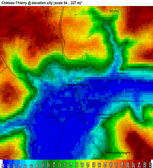
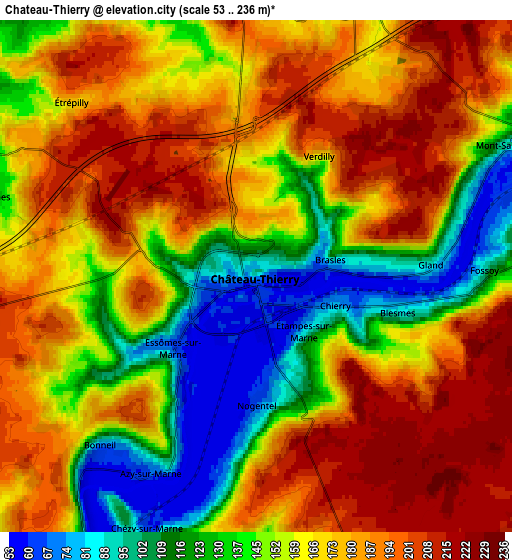
Below is the Elevation map of Château-Thierry, which displays elevation range with different colors. Scale of the first map is from 54 to 227 m (177 to 745 ft) with average elevation of 128.6 meters (=422 ft) [note 1]
These maps also provides idea of topography and contour of this city, they are displayed at different zoom levels. More info about maps, scale and edge coordinates you can find below images.
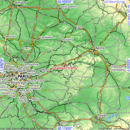
| \ | Map #1 | Map #2 | Topo.Map |
| Scale [m] | 54..227 m | 53..236 m | × |
| Scale [ft] | 177..745 ft | 174..774 ft | × |
| Average | 128.6 m = 422 ft | 162.1 m = 532 ft | × |
| Width | 6.41 km = 4 mi | 12.81 km = 8 mi | 205 km = 127.4 mi |
| Height | 6.41 km = 4 mi | 12.81 km = 8 mi | 205 km = 127.4 mi |
| ↑Max Latitude | 49.075156° | 49.103934° | 49.95955° |
| Latitude at center | 49.04636° | 49.04636° | 49.04636° |
| ↓Min Latitude | 49.017548° | 48.988719° | 48.11608° |
| ← Min Longitude | 3.359095° | 3.315149° | 1.99679° |
| Longitude center | 3.40304° | 3.40304° | 3.40304° |
| →Max Longitude | 3.446985° | 3.490931° | 4.80929° |
Nearby cities:
Cities around Château-Thierry sort by population:
• Charly-sur-Marne elevation 66 m
11.5 km,  228°
228°
• Essômes-sur-Marne 63 m
2.8 km, 225°
• Nogent-l’Artaud 66 m
10.8 km,  213°
213°
• Chézy-sur-Marne 63 m
6.9 km,  201°
201°
• Étampes-sur-Marne 78 m
1.7 km,  138°
138°
• Crézancy 77 m
7.8 km,  88°
88°
• Brasles 70 m
2 km,  84°
84°
• Montreuil-aux-Lions 141 m
15.4 km,  259°
259°
• Coincy 107 m
12.8 km,  6°
6°
• Nesles-la-Montagne 132 m
3.4 km,  150°
150°
• Chierry 80 m
2.1 km,  111°
111°
• Nogentel 66 m
3.2 km,  180°
180°
Multilingual:
 En español:
Château-Thierry elevación 62 m.
 En France:
Château-Thierry élévation 62 m.
 Auf Deutsch:
Château-Thierry höhe über dem Meeresspiegel ist 62 m.

Sources and notes:
- [note 1] Map square and city borders are not equal. Map elevation data is calculated only from area inside that square.
- [src 1] Elevation data from geonames database provided with same terms of usage.
- [src 2] The elevation map of Château-Thierry is generated using elevation data from NASA's 3 arcsec (90m) resolution SRTM data.
- [src 3] Base (background) map © OpenStreetMap contributors tiles are generated by Geofabrik and OpenTopoMap.
Copyright & License:
This Château-Thierry Elevation Map is licensed under CC BY-SA. You may reuse any part from this page, if you give a proper credit by linking to this URL:
 More info on terms of use page.