Châtelaillon-Plage elevation
Châtelaillon-Plage (Nouvelle-Aquitaine, Charente-Maritime), France elevation is 5 meters and Châtelaillon-Plage elevation in feet is 16 ft above sea level [src 1]. Châtelaillon-Plage is a populated place (feature code) with elevation that is 169 meters (554 ft) smaller than average city elevation in France.
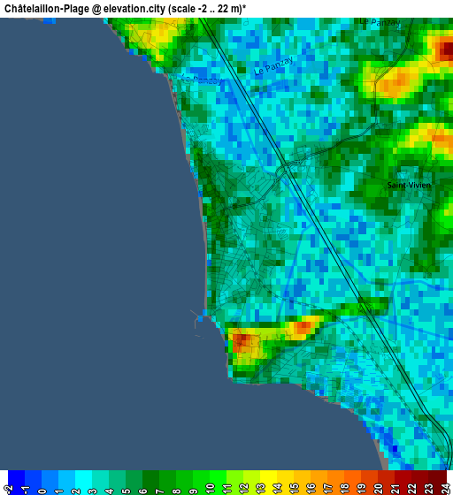
Below is the Elevation map of Châtelaillon-Plage, which displays elevation range with different colors. Scale of the first map is from -2 to 22 m (-7 to 72 ft) with average elevation of 4.2 meters (=14 ft) [note 1]
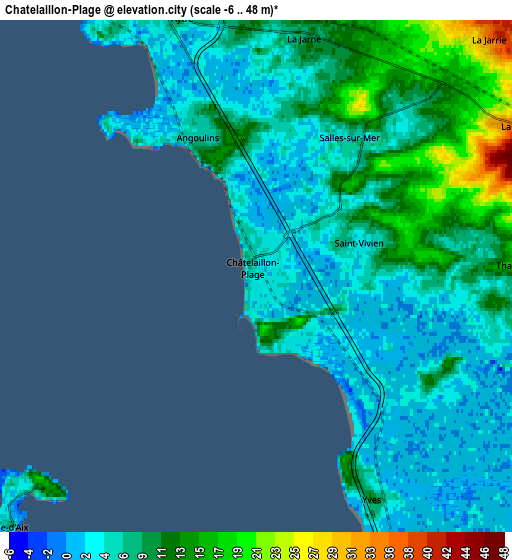
These maps also provides idea of topography and contour of this city, they are displayed at different zoom levels. More info about maps, scale and edge coordinates you can find below images.
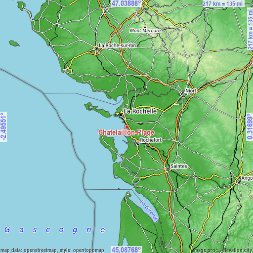
| \ | Map #1 | Map #2 | Topo.Map |
| Scale [m] | -2..22 m | -6..48 m | × |
| Scale [ft] | -7..72 ft | -20..157 ft | × |
| Average | 4.2 m = 14 ft | 7.7 m = 25 ft | × |
| Width | 6.78 km = 4.2 mi | 13.56 km = 8.4 mi | 217 km = 134.8 mi |
| Height | 6.78 km = 4.2 mi | 13.56 km = 8.4 mi | 216.9 km = 134.8 mi |
| ↑Max Latitude | 46.102379° | 46.132841° | 47.03888° |
| Latitude at center | 46.0719° | 46.0719° | 46.0719° |
| ↓Min Latitude | 46.041404° | 46.010892° | 45.08768° |
| ← Min Longitude | -1.133205° | -1.177151° | -2.49551° |
| Longitude center | -1.08926° | -1.08926° | -1.08926° |
| →Max Longitude | -1.045315° | -1.001369° | 0.31699° |
Nearby cities:
Cities around Châtelaillon-Plage sort by population:
• La Rochelle elevation 12 m
11.5 km,  336°
336°
• Aytré 13 m
7.4 km, 344°
• Périgny 15 m
9.3 km,  355°
355°
• Fouras 13 m
9.4 km,  181°
181°
• Angoulins 5 m
4 km, 339°
• La Jarrie 37 m
8.9 km,  44°
44°
• La Jarne 9 m
6.3 km,  11°
11°
• Salles-sur-Mer 8 m
4.5 km,  33°
33°
• Saint-Rogatien 21 m
8.8 km, 9°
• Saint-Laurent-de-la-Prée 9 m
10.7 km,  157°
157°
• Thairé 16 m
6.7 km,  88°
88°
• Yves 8 m
6.7 km,  151°
151°
Multilingual:
 En español:
Châtelaillon-Plage elevación 5 m.
 En France:
Châtelaillon-Plage élévation 5 m.
 Auf Deutsch:
Châtelaillon-Plage höhe über dem Meeresspiegel ist 5 m.

Sources and notes:
- [note 1] Map square and city borders are not equal. Map elevation data is calculated only from area inside that square.
- [src 1] Elevation data from geonames database provided with same terms of usage.
- [src 2] The elevation map of Châtelaillon-Plage is generated using elevation data from NASA's 3 arcsec (90m) resolution SRTM data.
- [src 3] Base (background) map © OpenStreetMap contributors tiles are generated by Geofabrik and OpenTopoMap.
Copyright & License:
This Châtelaillon-Plage Elevation Map is licensed under CC BY-SA. You may reuse any part from this page, if you give a proper credit by linking to this URL:
 More info on terms of use page.