Châtel-Saint-Germain elevation
Châtel-Saint-Germain (Grand Est, Moselle), France elevation is 201 meters and Châtel-Saint-Germain elevation in feet is 659 ft above sea level [src 1]. Châtel-Saint-Germain is a populated place (feature code) with elevation that is 27 meters (89 ft) bigger than average city elevation in France.
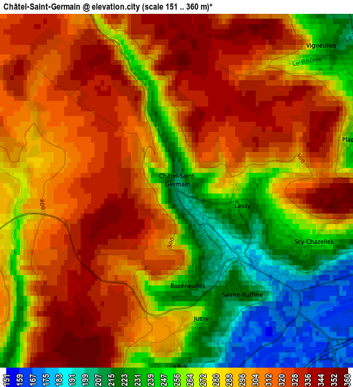
Below is the Elevation map of Châtel-Saint-Germain, which displays elevation range with different colors. Scale of the first map is from 151 to 360 m (495 to 1181 ft) with average elevation of 285.4 meters (=936 ft) [note 1]
These maps also provides idea of topography and contour of this city, they are displayed at different zoom levels. More info about maps, scale and edge coordinates you can find below images.
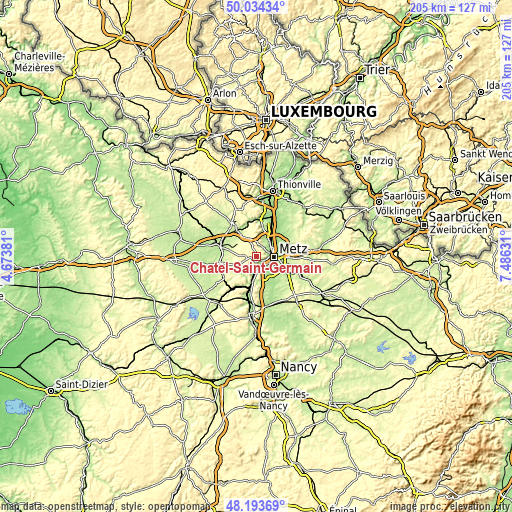
| \ | Map #1 | Topo.Map |
| Scale [m] | 151..360 m | × |
| Scale [ft] | 495..1181 ft | × |
| Average | 285.4 m = 936 ft | × |
| Width | 6.4 km = 4 mi | 204.7 km = 127.2 mi |
| Height | 6.4 km = 4 mi | 204.6 km = 127.1 mi |
| ↑Max Latitude | 49.151301° | 50.03434° |
| Latitude at center | 49.12255° | 49.12255° |
| ↓Min Latitude | 49.093782° | 48.19369° |
| ← Min Longitude | 6.036115° | 4.67381° |
| Longitude center | 6.08006° | 6.08006° |
| →Max Longitude | 6.124005° | 7.48631° |
Nearby cities:
Cities around Châtel-Saint-Germain sort by population:
• Metz elevation 182 m
6.8 km,  93°
93°
• Montigny-lès-Metz 185 m
6.1 km,  119°
119°
• Woippy 166 m
6.1 km,  58°
58°
• Ars-sur-Moselle 180 m
5 km,  184°
184°
• Moulins-lès-Metz 167 m
2.9 km,  134°
134°
• Le Ban Saint-Martin 166 m
5.2 km, 90°
• Longeville-lès-Metz 167 m
4.2 km,  103°
103°
• Scy-Chazelles 194 m
2.7 km,  111°
111°
• Plappeville 237 m
3.4 km,  75°
75°
• Amanvillers 325 m
5.7 km,  332°
332°
• Saulny 210 m
4.4 km,  28°
28°
• Rozérieulles 223 m
1.8 km, 175°
Multilingual:
 En español:
Châtel-Saint-Germain elevación 201 m.
 En France:
Châtel-Saint-Germain élévation 201 m.
 Auf Deutsch:
Châtel-Saint-Germain höhe über dem Meeresspiegel ist 201 m.

Sources and notes:
- [note 1] Map square and city borders are not equal. Map elevation data is calculated only from area inside that square.
- [src 1] Elevation data from geonames database provided with same terms of usage.
- [src 2] The elevation map of Châtel-Saint-Germain is generated using elevation data from NASA's 3 arcsec (90m) resolution SRTM data.
- [src 3] Base (background) map © OpenStreetMap contributors tiles are generated by Geofabrik and OpenTopoMap.
Copyright & License:
This Châtel-Saint-Germain Elevation Map is licensed under CC BY-SA. You may reuse any part from this page, if you give a proper credit by linking to this URL:
 More info on terms of use page.