Clères elevation
Clères (Normandy, Seine-Maritime), France elevation is 94 meters and Clères elevation in feet is 308 ft above sea level [src 1]. Clères is a populated place (feature code) with elevation that is 80 meters (262 ft) smaller than average city elevation in France.
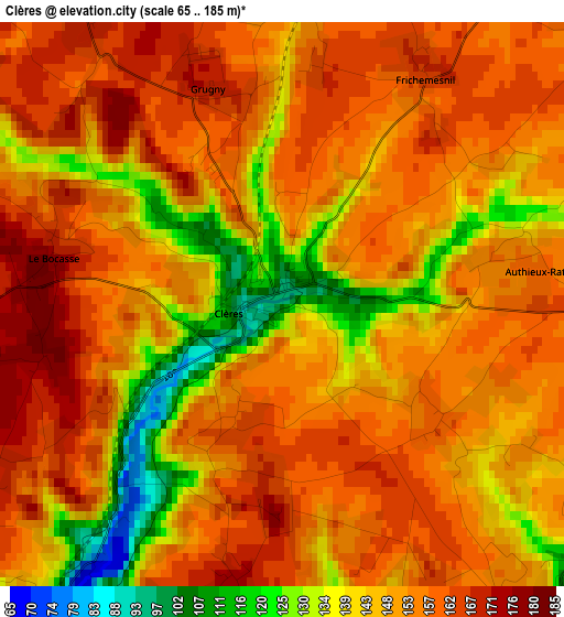
Below is the Elevation map of Clères, which displays elevation range with different colors. Scale of the first map is from 65 to 185 m (213 to 607 ft) with average elevation of 151 meters (=495 ft) [note 1]
These maps also provides idea of topography and contour of this city, they are displayed at different zoom levels. More info about maps, scale and edge coordinates you can find below images.
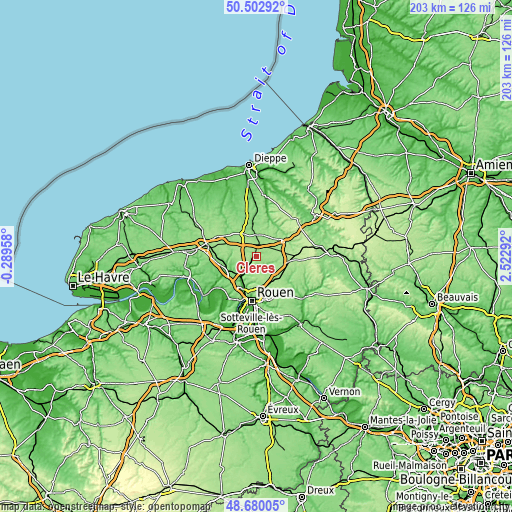
| \ | Map #1 | Topo.Map |
| Scale [m] | 65..185 m | × |
| Scale [ft] | 213..607 ft | × |
| Average | 151 m = 495 ft | × |
| Width | 6.33 km = 3.9 mi | 202.7 km = 126 mi |
| Height | 6.33 km = 3.9 mi | 202.7 km = 126 mi |
| ↑Max Latitude | 49.628474° | 50.50292° |
| Latitude at center | 49.6° | 49.6° |
| ↓Min Latitude | 49.57151° | 48.68005° |
| ← Min Longitude | 1.072725° | -0.28958° |
| Longitude center | 1.11667° | 1.11667° |
| →Max Longitude | 1.160615° | 2.52292° |
Nearby cities:
Cities around Clères sort by population:
• Pavilly elevation 56 m
12.3 km,  252°
252°
• Malaunay 40 m
9.7 km,  213°
213°
• Le Houlme 32 m
11.6 km, 210°
• Quincampoix 167 m
9.6 km,  147°
147°
• Houppeville 152 m
10.1 km,  195°
195°
• Isneauville 148 m
11.6 km,  166°
166°
• Fontaine-le-Bourg 84 m
5.2 km,  139°
139°
• Bosc-le-Hard 161 m
5.2 km,  54°
54°
• Eslettes 147 m
7.3 km,  217°
217°
• Saint-Jean-du-Cardonnay 128 m
13 km, 215°
• Pissy-Pôville 131 m
11.9 km,  228°
228°
• Tôtes 164 m
10.3 km,  330°
330°
Multilingual:
 En español:
Clères elevación 94 m.
 En France:
Clères élévation 94 m.


Sources and notes:
- [note 1] Map square and city borders are not equal. Map elevation data is calculated only from area inside that square.
- [src 1] Elevation data from geonames database provided with same terms of usage.
- [src 2] The elevation map of Clères is generated using elevation data from NASA's 3 arcsec (90m) resolution SRTM data.
- [src 3] Base (background) map © OpenStreetMap contributors tiles are generated by Geofabrik and OpenTopoMap.
Copyright & License:
This Clères Elevation Map is licensed under CC BY-SA. You may reuse any part from this page, if you give a proper credit by linking to this URL:
 More info on terms of use page.