Clion elevation
Clion (Centre, Département de l'Indre), France elevation is 102 meters and Clion elevation in feet is 335 ft above sea level [src 1]. Clion is a populated place (feature code) with elevation that is 72 meters (236 ft) smaller than average city elevation in France.
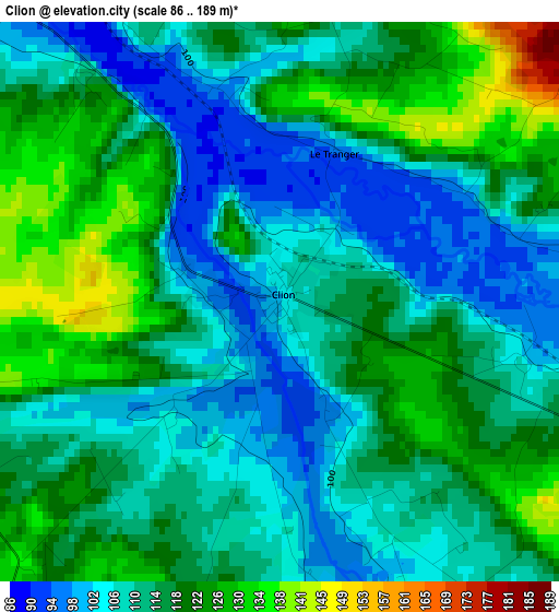
Below is the Elevation map of Clion, which displays elevation range with different colors. Scale of the first map is from 86 to 189 m (282 to 620 ft) with average elevation of 113.7 meters (=373 ft) [note 1]
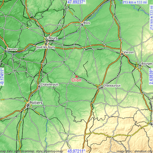
These maps also provides idea of topography and contour of this city, they are displayed at different zoom levels. More info about maps, scale and edge coordinates you can find below images.
| \ | Map #1 | Topo.Map |
| Scale [m] | 86..189 m | × |
| Scale [ft] | 282..620 ft | × |
| Average | 113.7 m = 373 ft | × |
| Width | 6.67 km = 4.1 mi | 213.5 km = 132.7 mi |
| Height | 6.67 km = 4.1 mi | 213.5 km = 132.7 mi |
| ↑Max Latitude | 46.970845° | 47.89237° |
| Latitude at center | 46.94085° | 46.94085° |
| ↓Min Latitude | 46.910838° | 45.97211° |
| ← Min Longitude | 1.188195° | -0.17411° |
| Longitude center | 1.23214° | 1.23214° |
| →Max Longitude | 1.276085° | 2.63839° |
Nearby cities:
Cities around Clion sort by population:
• Buzançais elevation 107 m
15.4 km,  112°
112°
• Châtillon-sur-Indre 103 m
6.9 km,  318°
318°
• Villedieu-sur-Indre 128 m
25.6 km, 114°
• Beaulieu-lès-Loches 76 m
26.3 km, 321°
• Luçay-le-Mâle 120 m
26.4 km,  37°
37°
• Perrusson 80 m
24.1 km, 316°
• Écueillé 143 m
18.2 km,  28°
28°
• Mézières-en-Brenne 90 m
13.6 km,  186°
186°
• Preuilly-sur-Claise 87 m
24.9 km,  247°
247°
• Martizay 82 m
20.6 km,  224°
224°
• Vendœuvres 118 m
18 km,  150°
150°
• Azay-le-Ferron 106 m
15.8 km,  230°
230°
Multilingual:
 En español:
Clion elevación 102 m.
 En France:
Clion élévation 102 m.


Sources and notes:
- [note 1] Map square and city borders are not equal. Map elevation data is calculated only from area inside that square.
- [src 1] Elevation data from geonames database provided with same terms of usage.
- [src 2] The elevation map of Clion is generated using elevation data from NASA's 3 arcsec (90m) resolution SRTM data.
- [src 3] Base (background) map © OpenStreetMap contributors tiles are generated by Geofabrik and OpenTopoMap.
Copyright & License:
This Clion Elevation Map is licensed under CC BY-SA. You may reuse any part from this page, if you give a proper credit by linking to this URL:
 More info on terms of use page.