Cognac elevation
Cognac (Nouvelle-Aquitaine, Charente), France elevation is 29 meters and Cognac elevation in feet is 95 ft above sea level [src 1]. Cognac is a seat of a third-order administrative division (feature code) with elevation that is 145 meters (476 ft) smaller than average city elevation in France.
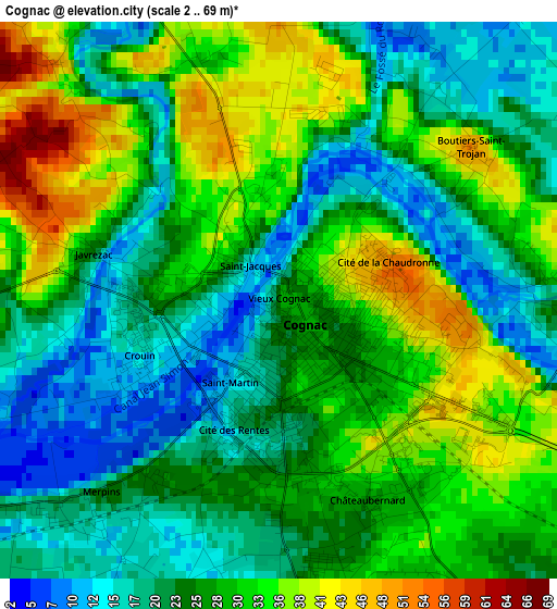
Below is the Elevation map of Cognac, which displays elevation range with different colors. Scale of the first map is from 2 to 69 m (7 to 226 ft) with average elevation of 26.7 meters (=88 ft) [note 1]
These maps also provides idea of topography and contour of this city, they are displayed at different zoom levels. More info about maps, scale and edge coordinates you can find below images.
| \ | Map #1 | Map #2 | Topo.Map |
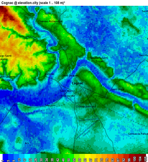
| Scale [m] | 2..69 m | 1..108 m | × |
| Scale [ft] | 7..226 ft | 3..354 ft | × |
| Average | 26.7 m = 88 ft | 26.9 m = 88 ft | × |
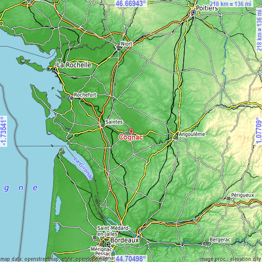
| Width | 6.83 km = 4.2 mi | 13.65 km = 8.5 mi | 218.4 km = 135.7 mi |
| Height | 6.83 km = 4.2 mi | 13.65 km = 8.5 mi | 218.4 km = 135.7 mi |
| ↑Max Latitude | 45.726516° | 45.757185° | 46.66943° |
| Latitude at center | 45.69583° | 45.69583° | 45.69583° |
| ↓Min Latitude | 45.665127° | 45.634408° | 44.70498° |
| ← Min Longitude | -0.373105° | -0.417051° | -1.73541° |
| Longitude center | -0.32916° | -0.32916° | -0.32916° |
| →Max Longitude | -0.285215° | -0.241269° | 1.07709° |
Nearby cities:
Cities around Cognac sort by population:
• Jarnac elevation 30 m
12.2 km,  97°
97°
• Châteaubernard 19 m
3.3 km,  185°
185°
• Cherves-Richemont 53 m
5.6 km,  342°
342°
• Segonzac 60 m
12.4 km,  135°
135°
• Gensac-la-Pallue 19 m
8 km,  129°
129°
• Boutiers-Saint-Trojan 13 m
3.2 km,  44°
44°
• Burie 62 m
11.2 km,  319°
319°
• Saint-Sulpice-de-Cognac 15 m
8.2 km,  330°
330°
• Chassors 43 m
8.7 km,  86°
86°
• Chérac 60 m
8.6 km,  276°
276°
• Nercillac 13 m
6.6 km,  69°
69°
• Saint-Brice 51 m
3.8 km,  111°
111°
Multilingual:
 En español:
Cognac elevación 29 m.
 En France:
Cognac élévation 29 m.


Sources and notes:
- [note 1] Map square and city borders are not equal. Map elevation data is calculated only from area inside that square.
- [src 1] Elevation data from geonames database provided with same terms of usage.
- [src 2] The elevation map of Cognac is generated using elevation data from NASA's 3 arcsec (90m) resolution SRTM data.
- [src 3] Base (background) map © OpenStreetMap contributors tiles are generated by Geofabrik and OpenTopoMap.
Copyright & License:
This Cognac Elevation Map is licensed under CC BY-SA. You may reuse any part from this page, if you give a proper credit by linking to this URL:
 More info on terms of use page.