Cossé-le-Vivien elevation
Cossé-le-Vivien (Pays de la Loire, Mayenne), France elevation is 84 meters and Cossé-le-Vivien elevation in feet is 276 ft above sea level [src 1]. Cossé-le-Vivien is a populated place (feature code) with elevation that is 90 meters (295 ft) smaller than average city elevation in France.
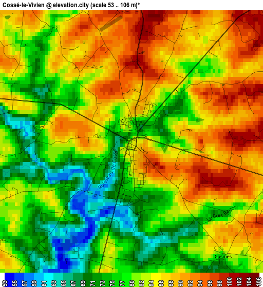
Below is the Elevation map of Cossé-le-Vivien, which displays elevation range with different colors. Scale of the first map is from 53 to 106 m (174 to 348 ft) with average elevation of 82.3 meters (=270 ft) [note 1]
These maps also provides idea of topography and contour of this city, they are displayed at different zoom levels. More info about maps, scale and edge coordinates you can find below images.
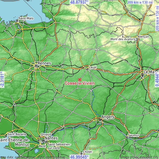
| \ | Map #1 | Topo.Map |
| Scale [m] | 53..106 m | × |
| Scale [ft] | 174..348 ft | × |
| Average | 82.3 m = 270 ft | × |
| Width | 6.55 km = 4.1 mi | 209.5 km = 130.2 mi |
| Height | 6.55 km = 4.1 mi | 209.5 km = 130.2 mi |
| ↑Max Latitude | 47.975418° | 48.87937° |
| Latitude at center | 47.94599° | 47.94599° |
| ↓Min Latitude | 47.916546° | 46.99545° |
| ← Min Longitude | -0.955795° | -2.3181° |
| Longitude center | -0.91185° | -0.91185° |
| →Max Longitude | -0.867905° | 0.4944° |
Nearby cities:
Cities around Cossé-le-Vivien sort by population:
• Laval elevation 71 m
17.9 km,  37°
37°
• Saint-Berthevin 105 m
14.6 km,  23°
23°
• Craon 53 m
11.4 km,  194°
194°
• Entrammes 59 m
15.8 km,  68°
68°
• Port-Brillet 137 m
19.1 km,  346°
346°
• Quelaines-Saint-Gault 81 m
8.4 km,  99°
99°
• Ahuillé 103 m
8.9 km, 20°
• Le Pertre 165 m
13.5 km,  316°
316°
• Loiron 145 m
13.5 km, 353°
• Montigné-le-Brillant 79 m
10 km,  45°
45°
• Nuillé-sur-Vicoin 62 m
10.5 km, 65°
• Ballots 79 m
11.5 km,  241°
241°
Multilingual:
 En español:
Cossé-le-Vivien elevación 84 m.
 En France:
Cossé-le-Vivien élévation 84 m.
 Auf Deutsch:
Cossé-le-Vivien höhe über dem Meeresspiegel ist 84 m.

Sources and notes:
- [note 1] Map square and city borders are not equal. Map elevation data is calculated only from area inside that square.
- [src 1] Elevation data from geonames database provided with same terms of usage.
- [src 2] The elevation map of Cossé-le-Vivien is generated using elevation data from NASA's 3 arcsec (90m) resolution SRTM data.
- [src 3] Base (background) map © OpenStreetMap contributors tiles are generated by Geofabrik and OpenTopoMap.
Copyright & License:
This Cossé-le-Vivien Elevation Map is licensed under CC BY-SA. You may reuse any part from this page, if you give a proper credit by linking to this URL:
 More info on terms of use page.