Coullons elevation
Coullons (Centre, Loiret), France elevation is 165 meters and Coullons elevation in feet is 541 ft above sea level [src 1]. Coullons is a populated place (feature code) with elevation that is 9 meters (30 ft) smaller than average city elevation in France.
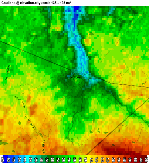
Below is the Elevation map of Coullons, which displays elevation range with different colors. Scale of the first map is from 135 to 193 m (443 to 633 ft) with average elevation of 164.6 meters (=540 ft) [note 1]
These maps also provides idea of topography and contour of this city, they are displayed at different zoom levels. More info about maps, scale and edge coordinates you can find below images.
| \ | Map #1 | Topo.Map |
| Scale [m] | 135..193 m | × |
| Scale [ft] | 443..633 ft | × |
| Average | 164.6 m = 540 ft | × |
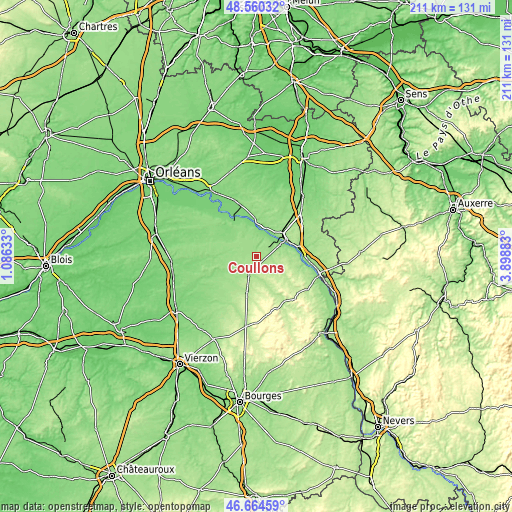
| Width | 6.59 km = 4.1 mi | 210.8 km = 131 mi |
| Height | 6.59 km = 4.1 mi | 210.8 km = 131 mi |
| ↑Max Latitude | 47.650662° | 48.56032° |
| Latitude at center | 47.62105° | 47.62105° |
| ↓Min Latitude | 47.591421° | 46.66459° |
| ← Min Longitude | 2.448635° | 1.08633° |
| Longitude center | 2.49258° | 2.49258° |
| →Max Longitude | 2.536525° | 3.89883° |
Nearby cities:
Cities around Coullons sort by population:
• Gien elevation 153 m
13.1 km,  52°
52°
• Aubigny-sur-Nère 186 m
15.3 km,  195°
195°
• Ouzouer-sur-Loire 136 m
16.2 km,  356°
356°
• Argent-sur-Sauldre 169 m
7.9 km,  207°
207°
• Poilly-lez-Gien 125 m
10 km, 51°
• Saint-Martin-sur-Ocre 138 m
13.1 km,  71°
71°
• Dampierre-en-Burly 147 m
15.7 km,  7°
7°
• Nevoy 140 m
12.3 km,  31°
31°
• Autry-le-Châtel 188 m
8.6 km,  106°
106°
• Saint-Brisson-sur-Loire 154 m
14.5 km,  78°
78°
• Cerdon 146 m
9.9 km,  279°
279°
• Blancafort 175 m
10.3 km,  164°
164°
Multilingual:
 En español:
Coullons elevación 165 m.
 En France:
Coullons élévation 165 m.
 Auf Deutsch:
Coullons höhe über dem Meeresspiegel ist 165 m.

Sources and notes:
- [note 1] Map square and city borders are not equal. Map elevation data is calculated only from area inside that square.
- [src 1] Elevation data from geonames database provided with same terms of usage.
- [src 2] The elevation map of Coullons is generated using elevation data from NASA's 3 arcsec (90m) resolution SRTM data.
- [src 3] Base (background) map © OpenStreetMap contributors tiles are generated by Geofabrik and OpenTopoMap.
Copyright & License:
This Coullons Elevation Map is licensed under CC BY-SA. You may reuse any part from this page, if you give a proper credit by linking to this URL:
 More info on terms of use page.