Courlon-sur-Yonne elevation
Courlon-sur-Yonne (Bourgogne-Franche-Comté, Département de l'Yonne), France elevation is 70 meters and Courlon-sur-Yonne elevation in feet is 230 ft above sea level [src 1]. Courlon-sur-Yonne is a populated place (feature code) with elevation that is 104 meters (341 ft) smaller than average city elevation in France.
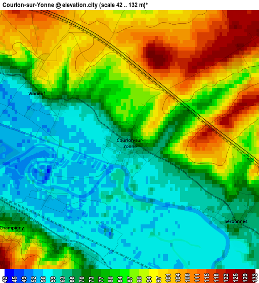
Below is the Elevation map of Courlon-sur-Yonne, which displays elevation range with different colors. Scale of the first map is from 42 to 132 m (138 to 433 ft) with average elevation of 79.4 meters (=260 ft) [note 1]
These maps also provides idea of topography and contour of this city, they are displayed at different zoom levels. More info about maps, scale and edge coordinates you can find below images.
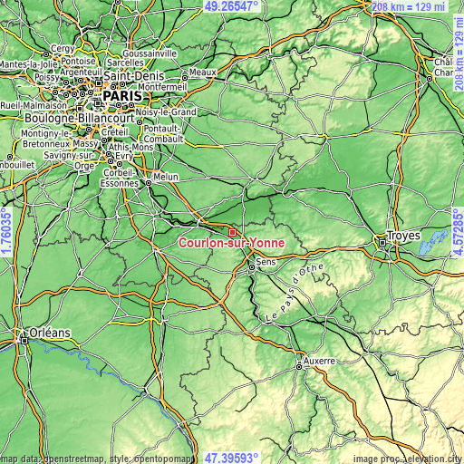
| \ | Map #1 | Topo.Map |
| Scale [m] | 42..132 m | × |
| Scale [ft] | 138..433 ft | × |
| Average | 79.4 m = 260 ft | × |
| Width | 6.5 km = 4 mi | 207.9 km = 129.2 mi |
| Height | 6.5 km = 4 mi | 207.9 km = 129.2 mi |
| ↑Max Latitude | 48.368473° | 49.26547° |
| Latitude at center | 48.33927° | 48.33927° |
| ↓Min Latitude | 48.31005° | 47.39593° |
| ← Min Longitude | 3.122655° | 1.76035° |
| Longitude center | 3.1666° | 3.1666° |
| →Max Longitude | 3.210545° | 4.57285° |
Nearby cities:
Cities around Courlon-sur-Yonne sort by population:
• Pont-sur-Yonne elevation 81 m
6.8 km,  157°
157°
• Saint-Germain-Laval 71 m
14.2 km,  298°
298°
• Cannes-Écluse 60 m
13.5 km,  281°
281°
• Villeneuve-la-Guyard 78 m
7.8 km,  271°
271°
• Bray-sur-Seine 58 m
9.8 km,  32°
32°
• Champigny 85 m
3.5 km,  224°
224°
• Villeblevin 78 m
6.6 km,  255°
255°
• Marolles-sur-Seine 53 m
11 km, 298°
• Vinneuf 75 m
2.2 km, 296°
• Sergines 103 m
7.1 km,  87°
87°
• Châtenay-sur-Seine 51 m
10.3 km,  328°
328°
• Salins 75 m
14.1 km,  310°
310°
Multilingual:
 En español:
Courlon-sur-Yonne elevación 70 m.
 En France:
Courlon-sur-Yonne élévation 70 m.
 Auf Deutsch:
Courlon-sur-Yonne höhe über dem Meeresspiegel ist 70 m.

Sources and notes:
- [note 1] Map square and city borders are not equal. Map elevation data is calculated only from area inside that square.
- [src 1] Elevation data from geonames database provided with same terms of usage.
- [src 2] The elevation map of Courlon-sur-Yonne is generated using elevation data from NASA's 3 arcsec (90m) resolution SRTM data.
- [src 3] Base (background) map © OpenStreetMap contributors tiles are generated by Geofabrik and OpenTopoMap.
Copyright & License:
This Courlon-sur-Yonne Elevation Map is licensed under CC BY-SA. You may reuse any part from this page, if you give a proper credit by linking to this URL:
 More info on terms of use page.