Coutances elevation
Coutances (Normandy, Manche), France elevation is 56 meters and Coutances elevation in feet is 184 ft above sea level [src 1]. Coutances is a seat of a third-order administrative division (feature code) with elevation that is 118 meters (387 ft) smaller than average city elevation in France.
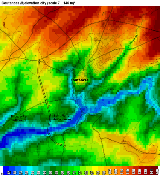
Below is the Elevation map of Coutances, which displays elevation range with different colors. Scale of the first map is from 7 to 146 m (23 to 479 ft) with average elevation of 79.4 meters (=260 ft) [note 1]
These maps also provides idea of topography and contour of this city, they are displayed at different zoom levels. More info about maps, scale and edge coordinates you can find below images.
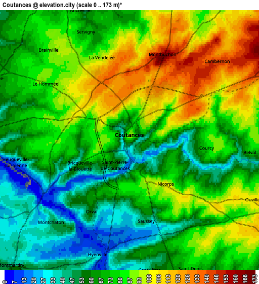
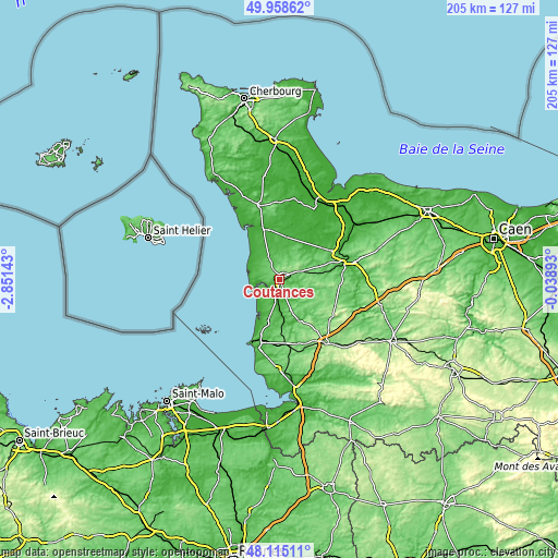
| \ | Map #1 | Map #2 | Topo.Map |
| Scale [m] | 7..146 m | 0..173 m | × |
| Scale [ft] | 23..479 ft | 0..568 ft | × |
| Average | 79.4 m = 260 ft | 75.8 m = 249 ft | × |
| Width | 6.41 km = 4 mi | 12.81 km = 8 mi | 205 km = 127.4 mi |
| Height | 6.41 km = 4 mi | 12.81 km = 8 mi | 205 km = 127.4 mi |
| ↑Max Latitude | 49.074206° | 49.102985° | 49.95862° |
| Latitude at center | 49.04541° | 49.04541° | 49.04541° |
| ↓Min Latitude | 49.016597° | 48.987768° | 48.11511° |
| ← Min Longitude | -1.489125° | -1.533071° | -2.85143° |
| Longitude center | -1.44518° | -1.44518° | -1.44518° |
| →Max Longitude | -1.401235° | -1.357289° | -0.03893° |
Nearby cities:
Cities around Coutances sort by population:
• Agon-Coutainville elevation 34 m
9.5 km,  267°
267°
• Bréhal 52 m
17 km,  196°
196°
• Périers 29 m
15.9 km,  9°
9°
• Marigny 78 m
16 km,  67°
67°
• Cérences 53 m
14.3 km,  176°
176°
• Gouville-sur-Mer 23 m
11.3 km,  300°
300°
• Gavray 31 m
16.5 km,  155°
155°
• Saint-Sauveur-Lendelin 68 m
9.7 km, 13°
• Blainville-sur-Mer 27 m
10.3 km,  282°
282°
• Quettreville-sur-Sienne 32 m
8.8 km,  190°
190°
• Montmartin-sur-Mer 56 m
8.6 km,  222°
222°
• Cerisy-la-Salle 131 m
12 km,  100°
100°
Multilingual:
 En español:
Coutances elevación 56 m.
 En France:
Coutances élévation 56 m.
 Auf Deutsch:
Coutances höhe über dem Meeresspiegel ist 56 m.

Sources and notes:
- [note 1] Map square and city borders are not equal. Map elevation data is calculated only from area inside that square.
- [src 1] Elevation data from geonames database provided with same terms of usage.
- [src 2] The elevation map of Coutances is generated using elevation data from NASA's 3 arcsec (90m) resolution SRTM data.
- [src 3] Base (background) map © OpenStreetMap contributors tiles are generated by Geofabrik and OpenTopoMap.
Copyright & License:
This Coutances Elevation Map is licensed under CC BY-SA. You may reuse any part from this page, if you give a proper credit by linking to this URL:
 More info on terms of use page.