Déols elevation
Déols (Centre, Département de l'Indre), France elevation is 149 meters and Déols elevation in feet is 489 ft above sea level [src 1]. Déols is a populated place (feature code) with elevation that is 25 meters (82 ft) smaller than average city elevation in France.
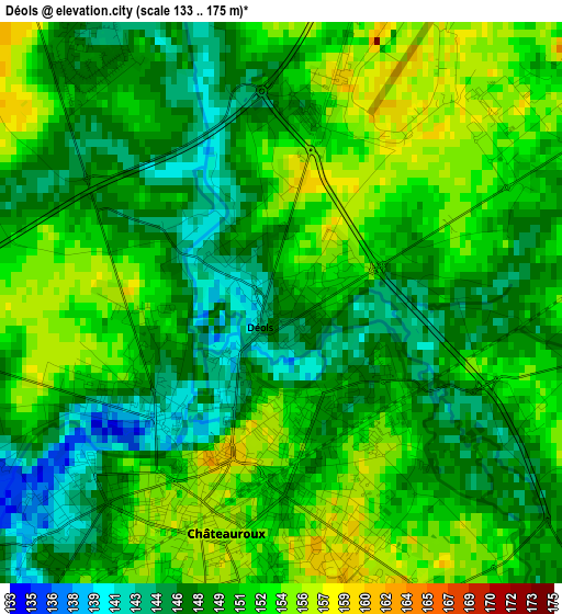
Below is the Elevation map of Déols, which displays elevation range with different colors. Scale of the first map is from 133 to 175 m (436 to 574 ft) with average elevation of 149.9 meters (=492 ft) [note 1]
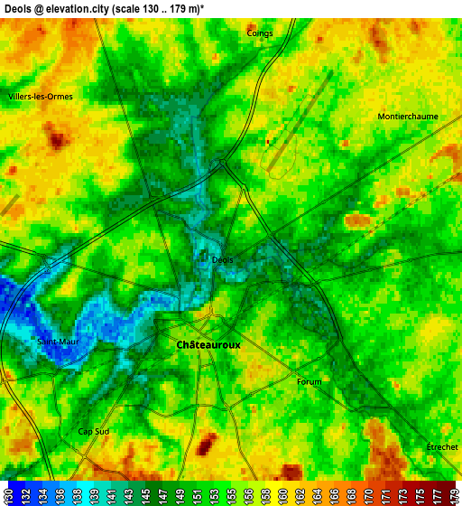
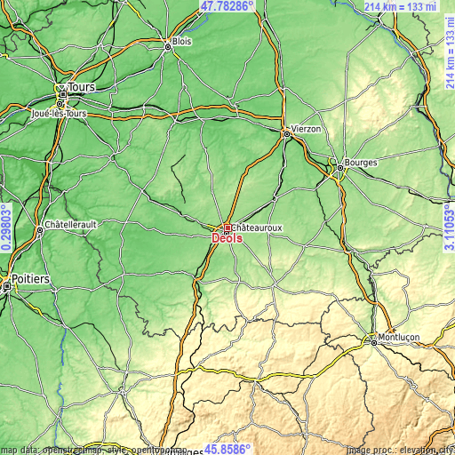
These maps also provides idea of topography and contour of this city, they are displayed at different zoom levels. More info about maps, scale and edge coordinates you can find below images.
| \ | Map #1 | Map #2 | Topo.Map |
| Scale [m] | 133..175 m | 130..179 m | × |
| Scale [ft] | 436..574 ft | 427..587 ft | × |
| Average | 149.9 m = 492 ft | 153.6 m = 504 ft | × |
| Width | 6.69 km = 4.2 mi | 13.37 km = 8.3 mi | 214 km = 133 mi |
| Height | 6.69 km = 4.2 mi | 13.37 km = 8.3 mi | 213.9 km = 132.9 mi |
| ↑Max Latitude | 46.859398° | 46.889439° | 47.78286° |
| Latitude at center | 46.82934° | 46.82934° | 46.82934° |
| ↓Min Latitude | 46.799265° | 46.769174° | 45.8586° |
| ← Min Longitude | 1.660335° | 1.616389° | 0.29803° |
| Longitude center | 1.70428° | 1.70428° | 1.70428° |
| →Max Longitude | 1.748225° | 1.792171° | 3.11053° |
Nearby cities:
Cities around Déols sort by population:
• Châteauroux elevation 151 m
2 km,  203°
203°
• Le Poinçonnet 165 m
7.3 km,  171°
171°
• Ardentes 164 m
13.9 km,  134°
134°
• Saint-Maur 143 m
5.6 km,  242°
242°
• Levroux 140 m
18 km,  337°
337°
• Villedieu-sur-Indre 128 m
12.7 km,  278°
278°
• Montierchaume 157 m
6.4 km,  53°
53°
• Niherne 131 m
10.7 km,  269°
269°
• Neuvy-Pailloux 150 m
13.5 km,  62°
62°
• Luant 143 m
15.5 km,  226°
226°
• Vineuil 170 m
9.5 km,  326°
326°
• Arthon 139 m
15.1 km,  181°
181°
Multilingual:
 En español:
Déols elevación 149 m.
 En France:
Déols élévation 149 m.


Sources and notes:
- [note 1] Map square and city borders are not equal. Map elevation data is calculated only from area inside that square.
- [src 1] Elevation data from geonames database provided with same terms of usage.
- [src 2] The elevation map of Déols is generated using elevation data from NASA's 3 arcsec (90m) resolution SRTM data.
- [src 3] Base (background) map © OpenStreetMap contributors tiles are generated by Geofabrik and OpenTopoMap.
Copyright & License:
This Déols Elevation Map is licensed under CC BY-SA. You may reuse any part from this page, if you give a proper credit by linking to this URL:
 More info on terms of use page.