Désaignes elevation
Désaignes (Auvergne-Rhône-Alpes, Département de l'Ardèche), France elevation is 466 meters and Désaignes elevation in feet is 1529 ft above sea level [src 1]. Désaignes is a populated place (feature code) with elevation that is 292 meters (958 ft) bigger than average city elevation in France.
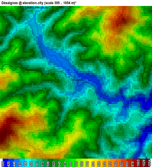
Below is the Elevation map of Désaignes, which displays elevation range with different colors. Scale of the first map is from 395 to 1054 m (1296 to 3458 ft) with average elevation of 634.8 meters (=2083 ft) [note 1]
These maps also provides idea of topography and contour of this city, they are displayed at different zoom levels. More info about maps, scale and edge coordinates you can find below images.
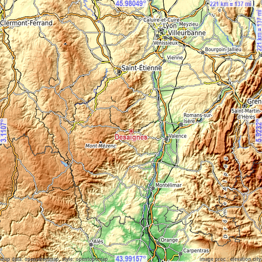
| \ | Map #1 | Topo.Map |
| Scale [m] | 395..1054 m | × |
| Scale [ft] | 1296..3458 ft | × |
| Average | 634.8 m = 2083 ft | × |
| Width | 6.91 km = 4.3 mi | 221.1 km = 137.4 mi |
| Height | 6.91 km = 4.3 mi | 221.1 km = 137.4 mi |
| ↑Max Latitude | 45.025728° | 45.98049° |
| Latitude at center | 44.99466° | 44.99466° |
| ↓Min Latitude | 44.963575° | 43.99157° |
| ← Min Longitude | 4.473005° | 3.1107° |
| Longitude center | 4.51695° | 4.51695° |
| →Max Longitude | 4.560895° | 5.9232° |
Nearby cities:
Cities around Désaignes sort by population:
• Le Cheylard elevation 440 m
12.3 km,  216°
216°
• Tence 858 m
22.2 km,  306°
306°
• Le Chambon-sur-Lignon 961 m
18.4 km,  293°
293°
• Saint-Agrève 1067 m
9.7 km,  280°
280°
• Lamastre 374 m
5 km,  100°
100°
• Vernoux-en-Vivarais 582 m
14.9 km,  137°
137°
• Satillieu 480 m
18.9 km,  23°
23°
• Saint-Martin-de-Valamas 558 m
13.3 km,  241°
241°
• Saint-Sauveur-de-Montagut 221 m
19.9 km,  165°
165°
• Saint-Félicien 496 m
13.4 km,  40°
40°
• Mauves 116 m
25 km,  78°
78°
• Mazet-Saint-Voy 1065 m
22.2 km, 285°
Multilingual:
 En español:
Désaignes elevación 466 m.
 En France:
Désaignes élévation 466 m.
 Auf Deutsch:
Désaignes höhe über dem Meeresspiegel ist 466 m.

Sources and notes:
- [note 1] Map square and city borders are not equal. Map elevation data is calculated only from area inside that square.
- [src 1] Elevation data from geonames database provided with same terms of usage.
- [src 2] The elevation map of Désaignes is generated using elevation data from NASA's 3 arcsec (90m) resolution SRTM data.
- [src 3] Base (background) map © OpenStreetMap contributors tiles are generated by Geofabrik and OpenTopoMap.
Copyright & License:
This Désaignes Elevation Map is licensed under CC BY-SA. You may reuse any part from this page, if you give a proper credit by linking to this URL:
 More info on terms of use page.