Dieuze elevation
Dieuze (Grand Est, Moselle), France elevation is 208 meters and Dieuze elevation in feet is 682 ft above sea level [src 1]. Dieuze is a populated place (feature code) with elevation that is 34 meters (112 ft) bigger than average city elevation in France.
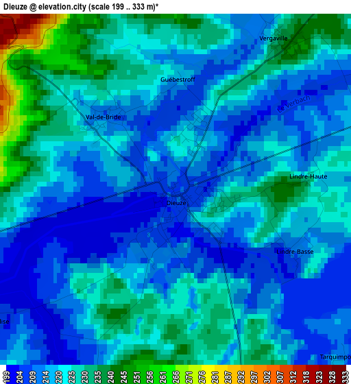
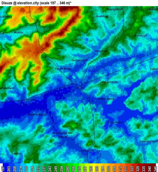
Below is the Elevation map of Dieuze, which displays elevation range with different colors. Scale of the first map is from 199 to 333 m (653 to 1093 ft) with average elevation of 220.7 meters (=724 ft) [note 1]
These maps also provides idea of topography and contour of this city, they are displayed at different zoom levels. More info about maps, scale and edge coordinates you can find below images.
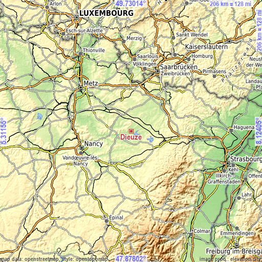
| \ | Map #1 | Map #2 | Topo.Map |
| Scale [m] | 199..333 m | 197..346 m | × |
| Scale [ft] | 653..1093 ft | 646..1135 ft | × |
| Average | 220.7 m = 724 ft | 233.3 m = 765 ft | × |
| Width | 6.44 km = 4 mi | 12.87 km = 8 mi | 205.9 km = 127.9 mi |
| Height | 6.44 km = 4 mi | 12.87 km = 8 mi | 205.9 km = 127.9 mi |
| ↑Max Latitude | 48.841561° | 48.870475° | 49.73014° |
| Latitude at center | 48.81263° | 48.81263° | 48.81263° |
| ↓Min Latitude | 48.783683° | 48.754719° | 47.87802° |
| ← Min Longitude | 6.673855° | 6.629909° | 5.31155° |
| Longitude center | 6.7178° | 6.7178° | 6.7178° |
| →Max Longitude | 6.761745° | 6.805691° | 8.12405° |
Nearby cities:
Cities around Dieuze sort by population:
• Sarrebourg elevation 270 m
26.3 km,  109°
109°
• Faulquemont 250 m
27.7 km,  341°
341°
• Morhange 257 m
13.5 km, 335°
• Créhange 310 m
29.1 km, 340°
• Château-Salins 205 m
14.9 km,  272°
272°
• Chanteheux 235 m
27.7 km,  210°
210°
• Vic-sur-Seille 208 m
14.1 km,  256°
256°
• Einville-au-Jard 221 m
24.4 km,  224°
224°
• Teting-sur-Nied 259 m
27.5 km,  351°
351°
• Lorquin 272 m
26 km,  127°
127°
• Champenoux 237 m
28.2 km,  253°
253°
• Holving 232 m
28.6 km,  39°
39°
Multilingual:
 En español:
Dieuze elevación 208 m.
 En France:
Dieuze élévation 208 m.


Sources and notes:
- [note 1] Map square and city borders are not equal. Map elevation data is calculated only from area inside that square.
- [src 1] Elevation data from geonames database provided with same terms of usage.
- [src 2] The elevation map of Dieuze is generated using elevation data from NASA's 3 arcsec (90m) resolution SRTM data.
- [src 3] Base (background) map © OpenStreetMap contributors tiles are generated by Geofabrik and OpenTopoMap.
Copyright & License:
This Dieuze Elevation Map is licensed under CC BY-SA. You may reuse any part from this page, if you give a proper credit by linking to this URL:
 More info on terms of use page.