Drancy elevation
Drancy (Île-de-France, Seine-Saint-Denis), France elevation is 47 meters and Drancy elevation in feet is 154 ft above sea level [src 1]. Drancy is a populated place (feature code) with elevation that is 127 meters (417 ft) smaller than average city elevation in France.
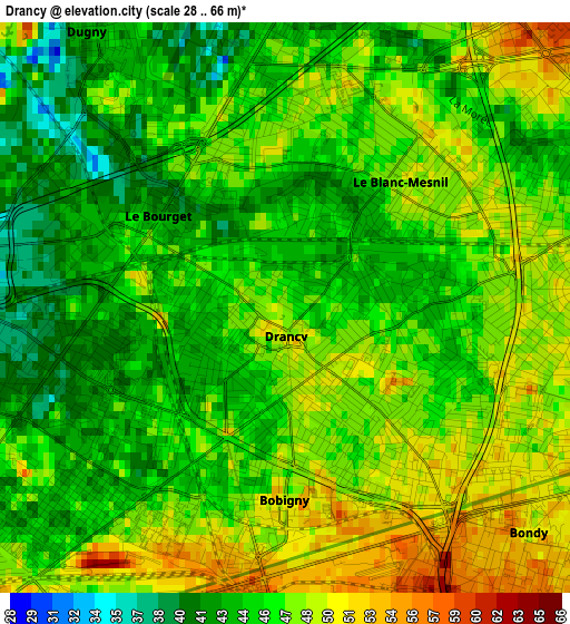
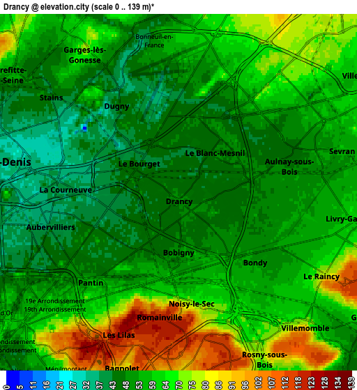
Below is the Elevation map of Drancy, which displays elevation range with different colors. Scale of the first map is from 28 to 66 m (92 to 217 ft) with average elevation of 46.3 meters (=152 ft) [note 1]
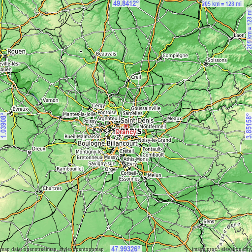
These maps also provides idea of topography and contour of this city, they are displayed at different zoom levels. More info about maps, scale and edge coordinates you can find below images.
| \ | Map #1 | Map #2 | Topo.Map |
| Scale [m] | 28..66 m | 0..139 m | × |
| Scale [ft] | 92..217 ft | 0..456 ft | × |
| Average | 46.3 m = 152 ft | 58.2 m = 191 ft | × |
| Width | 6.42 km = 4 mi | 12.84 km = 8 mi | 205.5 km = 127.7 mi |
| Height | 6.42 km = 4 mi | 12.84 km = 8 mi | 205.5 km = 127.7 mi |
| ↑Max Latitude | 48.954645° | 48.983494° | 49.8412° |
| Latitude at center | 48.92578° | 48.92578° | 48.92578° |
| ↓Min Latitude | 48.896898° | 48.867999° | 47.99326° |
| ← Min Longitude | 2.401385° | 2.357439° | 1.03908° |
| Longitude center | 2.44533° | 2.44533° | 2.44533° |
| →Max Longitude | 2.489275° | 2.533221° | 3.85158° |
Nearby cities:
Cities around Drancy sort by population:
• Aulnay-sous-Bois elevation 45 m
3.8 km,  68°
68°
• Aubervilliers 38 m
4.6 km,  257°
257°
• Pantin 55 m
4.4 km,  216°
216°
• Bondy 51 m
4.2 km,  129°
129°
• Le Blanc-Mesnil 48 m
1.9 km,  39°
39°
• Bobigny 49 m
1.8 km,  168°
168°
• Noisy-le-Sec 64 m
4.1 km,  159°
159°
• La Courneuve 38 m
3.6 km,  274°
274°
• Romainville 121 m
4.6 km,  189°
189°
• Les Pavillons-sous-Bois 55 m
4.9 km,  115°
115°
• Le Bourget 38 m
1.2 km,  322°
322°
• Dugny 44 m
3.7 km,  326°
326°
Multilingual:
 En español:
Drancy elevación 47 m.
 En France:
Drancy élévation 47 m.


Sources and notes:
- [note 1] Map square and city borders are not equal. Map elevation data is calculated only from area inside that square.
- [src 1] Elevation data from geonames database provided with same terms of usage.
- [src 2] The elevation map of Drancy is generated using elevation data from NASA's 3 arcsec (90m) resolution SRTM data.
- [src 3] Base (background) map © OpenStreetMap contributors tiles are generated by Geofabrik and OpenTopoMap.
Copyright & License:
This Drancy Elevation Map is licensed under CC BY-SA. You may reuse any part from this page, if you give a proper credit by linking to this URL:
 More info on terms of use page.