Duttlenheim elevation
Duttlenheim (Grand Est, Bas-Rhin), France elevation is 162 meters and Duttlenheim elevation in feet is 531 ft above sea level [src 1]. Duttlenheim is a populated place (feature code) with elevation that is 12 meters (39 ft) smaller than average city elevation in France.
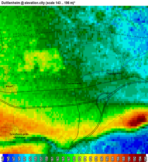
Below is the Elevation map of Duttlenheim, which displays elevation range with different colors. Scale of the first map is from 143 to 196 m (469 to 643 ft) with average elevation of 163 meters (=535 ft) [note 1]
These maps also provides idea of topography and contour of this city, they are displayed at different zoom levels. More info about maps, scale and edge coordinates you can find below images.
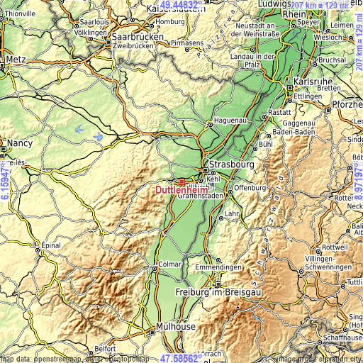
| \ | Map #1 | Topo.Map |
| Scale [m] | 143..196 m | × |
| Scale [ft] | 469..643 ft | × |
| Average | 163 m = 535 ft | × |
| Width | 6.47 km = 4 mi | 207.1 km = 128.7 mi |
| Height | 6.47 km = 4 mi | 207.1 km = 128.7 mi |
| ↑Max Latitude | 48.554626° | 49.44832° |
| Latitude at center | 48.52553° | 48.52553° |
| ↓Min Latitude | 48.496417° | 47.58562° |
| ← Min Longitude | 7.521775° | 6.15947° |
| Longitude center | 7.56572° | 7.56572° |
| →Max Longitude | 7.609665° | 8.97197° |
Nearby cities:
Cities around Duttlenheim sort by population:
• Molsheim elevation 182 m
5.7 km,  286°
286°
• Dorlisheim 183 m
5.9 km,  269°
269°
• Entzheim 148 m
5.4 km,  79°
79°
• Griesheim-près-Molsheim 172 m
3.6 km,  226°
226°
• Ernolsheim-Bruche 170 m
4.4 km,  359°
359°
• Krautergersheim 155 m
5.5 km,  178°
178°
• Duppigheim 160 m
2.1 km, 80°
• Hangenbieten 150 m
5.2 km,  43°
43°
• Blaesheim 153 m
3.8 km,  123°
123°
• Dachstein 166 m
4.7 km,  328°
328°
• Altorf 172 m
2.8 km,  261°
261°
• Innenheim 153 m
3.3 km,  168°
168°
Multilingual:
 En español:
Duttlenheim elevación 162 m.
 En France:
Duttlenheim élévation 162 m.
 Auf Deutsch:
Duttlenheim höhe über dem Meeresspiegel ist 162 m.

Sources and notes:
- [note 1] Map square and city borders are not equal. Map elevation data is calculated only from area inside that square.
- [src 1] Elevation data from geonames database provided with same terms of usage.
- [src 2] The elevation map of Duttlenheim is generated using elevation data from NASA's 3 arcsec (90m) resolution SRTM data.
- [src 3] Base (background) map © OpenStreetMap contributors tiles are generated by Geofabrik and OpenTopoMap.
Copyright & License:
This Duttlenheim Elevation Map is licensed under CC BY-SA. You may reuse any part from this page, if you give a proper credit by linking to this URL:
 More info on terms of use page.