Ensisheim elevation
Ensisheim (Grand Est, Haut-Rhin), France elevation is 218 meters and Ensisheim elevation in feet is 715 ft above sea level [src 1]. Ensisheim is a populated place (feature code) with elevation that is 44 meters (144 ft) bigger than average city elevation in France.
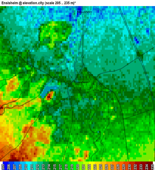
Below is the Elevation map of Ensisheim, which displays elevation range with different colors. Scale of the first map is from 205 to 235 m (673 to 771 ft) with average elevation of 215.7 meters (=708 ft) [note 1]
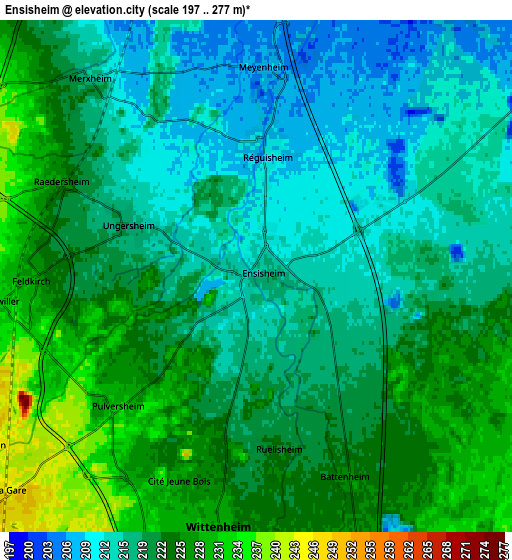
These maps also provides idea of topography and contour of this city, they are displayed at different zoom levels. More info about maps, scale and edge coordinates you can find below images.
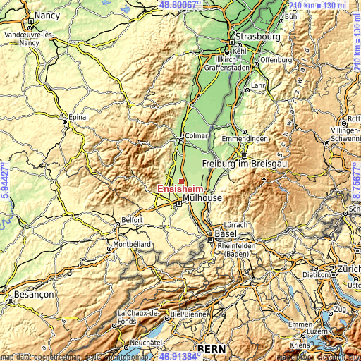
| \ | Map #1 | Map #2 | Topo.Map |
| Scale [m] | 205..235 m | 197..277 m | × |
| Scale [ft] | 673..771 ft | 646..909 ft | × |
| Average | 215.7 m = 708 ft | 219.7 m = 721 ft | × |
| Width | 6.56 km = 4.1 mi | 13.11 km = 8.1 mi | 209.8 km = 130.4 mi |
| Height | 6.56 km = 4.1 mi | 13.11 km = 8.1 mi | 209.8 km = 130.4 mi |
| ↑Max Latitude | 47.895313° | 47.92477° | 48.80067° |
| Latitude at center | 47.86584° | 47.86584° | 47.86584° |
| ↓Min Latitude | 47.83635° | 47.806843° | 46.91384° |
| ← Min Longitude | 7.306575° | 7.262629° | 5.94427° |
| Longitude center | 7.35052° | 7.35052° | 7.35052° |
| →Max Longitude | 7.394465° | 7.438411° | 8.75677° |
Nearby cities:
Cities around Ensisheim sort by population:
• Wittenheim elevation 228 m
6.3 km,  195°
195°
• Bollwiller 232 m
6.7 km,  262°
262°
• Ruelisheim 224 m
4.7 km,  173°
173°
• Pulversheim 231 m
4.8 km,  229°
229°
• Baldersheim 229 m
7.5 km,  162°
162°
• Réguisheim 212 m
3.3 km,  3°
3°
• Ungersheim 215 m
3.5 km,  293°
293°
• Munchhouse 217 m
7.6 km,  87°
87°
• Battenheim 225 m
5.6 km, 155°
• Merxheim 215 m
6.5 km,  320°
320°
• Meyenheim 210 m
5.3 km, 4°
• Raedersheim 226 m
5.7 km,  296°
296°
Multilingual:
 En español:
Ensisheim elevación 218 m.
 En France:
Ensisheim élévation 218 m.
 Auf Deutsch:
Ensisheim höhe über dem Meeresspiegel ist 218 m.

Sources and notes:
- [note 1] Map square and city borders are not equal. Map elevation data is calculated only from area inside that square.
- [src 1] Elevation data from geonames database provided with same terms of usage.
- [src 2] The elevation map of Ensisheim is generated using elevation data from NASA's 3 arcsec (90m) resolution SRTM data.
- [src 3] Base (background) map © OpenStreetMap contributors tiles are generated by Geofabrik and OpenTopoMap.
Copyright & License:
This Ensisheim Elevation Map is licensed under CC BY-SA. You may reuse any part from this page, if you give a proper credit by linking to this URL:
 More info on terms of use page.