Ernée elevation
Ernée (Pays de la Loire, Mayenne), France elevation is 142 meters and Ernée elevation in feet is 466 ft above sea level [src 1]. Ernée is a populated place (feature code) with elevation that is 32 meters (105 ft) smaller than average city elevation in France.
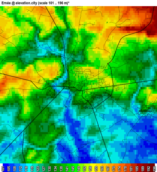
Below is the Elevation map of Ernée, which displays elevation range with different colors. Scale of the first map is from 101 to 196 m (331 to 643 ft) with average elevation of 137.3 meters (=450 ft) [note 1]
These maps also provides idea of topography and contour of this city, they are displayed at different zoom levels. More info about maps, scale and edge coordinates you can find below images.

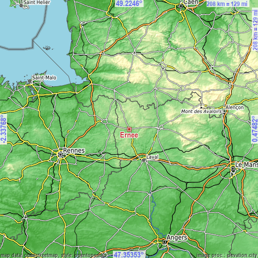
| \ | Map #1 | Map #2 | Topo.Map |
| Scale [m] | 101..196 m | 93..248 m | × |
| Scale [ft] | 331..643 ft | 305..814 ft | × |
| Average | 137.3 m = 450 ft | 151.9 m = 498 ft | × |
| Width | 6.5 km = 4 mi | 13 km = 8.1 mi | 208 km = 129.2 mi |
| Height | 6.5 km = 4 mi | 13 km = 8.1 mi | 208 km = 129.2 mi |
| ↑Max Latitude | 48.326867° | 48.356077° | 49.2246° |
| Latitude at center | 48.29764° | 48.29764° | 48.29764° |
| ↓Min Latitude | 48.268397° | 48.239136° | 47.35353° |
| ← Min Longitude | -0.975375° | -1.019321° | -2.33768° |
| Longitude center | -0.93143° | -0.93143° | -0.93143° |
| →Max Longitude | -0.887485° | -0.843539° | 0.47482° |
Nearby cities:
Cities around Ernée sort by population:
• Gorron elevation 163 m
15.4 km,  34°
34°
• Andouillé 85 m
17.3 km,  140°
140°
• Saint-Denis-de-Gastines 230 m
7.3 km,  47°
47°
• Le Bourgneuf-la-Forêt 152 m
15.2 km,  190°
190°
• Montenay 127 m
3 km,  111°
111°
• La Baconnière 181 m
13.4 km,  167°
167°
• Juvigné 166 m
10.8 km,  224°
224°
• Luitré 146 m
14 km,  263°
263°
• La Chapelle-Janson 122 m
13.8 km,  293°
293°
• Beaucé 83 m
17.4 km, 285°
• Chailland 94 m
9.1 km,  152°
152°
• Larchamp 203 m
8.7 km,  324°
324°
Multilingual:
 En español:
Ernée elevación 142 m.
 En France:
Ernée élévation 142 m.


Sources and notes:
- [note 1] Map square and city borders are not equal. Map elevation data is calculated only from area inside that square.
- [src 1] Elevation data from geonames database provided with same terms of usage.
- [src 2] The elevation map of Ernée is generated using elevation data from NASA's 3 arcsec (90m) resolution SRTM data.
- [src 3] Base (background) map © OpenStreetMap contributors tiles are generated by Geofabrik and OpenTopoMap.
Copyright & License:
This Ernée Elevation Map is licensed under CC BY-SA. You may reuse any part from this page, if you give a proper credit by linking to this URL:
 More info on terms of use page.