Eu elevation
Eu (Normandy, Seine-Maritime), France elevation is 15 meters and Eu elevation in feet is 49 ft above sea level [src 1]. Eu is a populated place (feature code) with elevation that is 159 meters (522 ft) smaller than average city elevation in France.
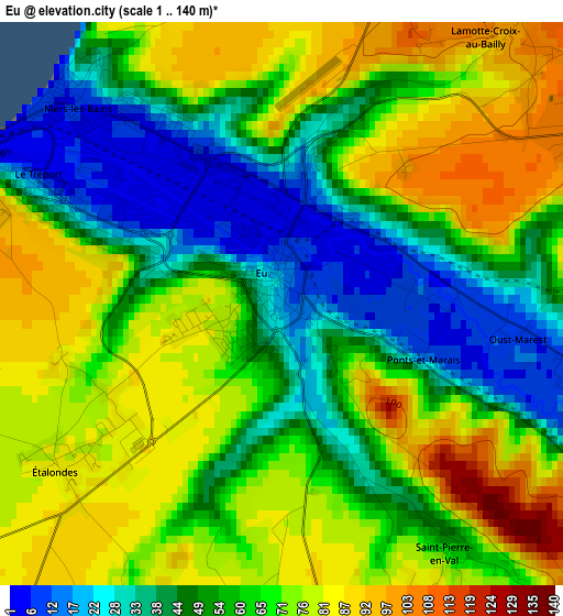
Below is the Elevation map of Eu, which displays elevation range with different colors. Scale of the first map is from 1 to 140 m (3 to 459 ft) with average elevation of 61.6 meters (=202 ft) [note 1]
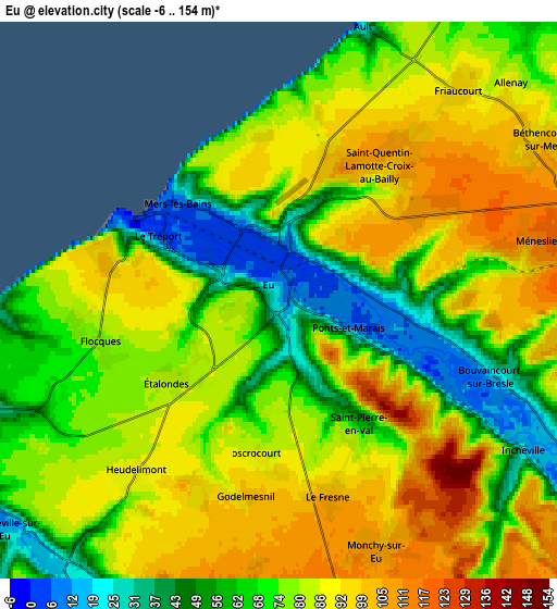
These maps also provides idea of topography and contour of this city, they are displayed at different zoom levels. More info about maps, scale and edge coordinates you can find below images.
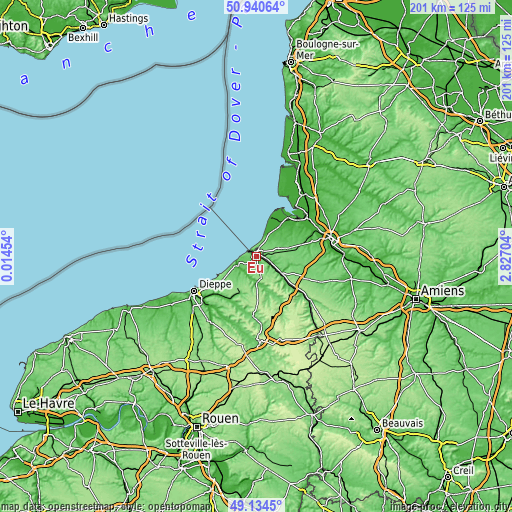
| \ | Map #1 | Map #2 | Topo.Map |
| Scale [m] | 1..140 m | -6..154 m | × |
| Scale [ft] | 3..459 ft | -20..505 ft | × |
| Average | 61.6 m = 202 ft | 77.7 m = 255 ft | × |
| Width | 6.28 km = 3.9 mi | 12.55 km = 7.8 mi | 200.8 km = 124.8 mi |
| Height | 6.28 km = 3.9 mi | 12.55 km = 7.8 mi | 200.8 km = 124.8 mi |
| ↑Max Latitude | 50.074272° | 50.102468° | 50.94064° |
| Latitude at center | 50.04606° | 50.04606° | 50.04606° |
| ↓Min Latitude | 50.017831° | 49.989586° | 49.1345° |
| ← Min Longitude | 1.376845° | 1.332899° | 0.01454° |
| Longitude center | 1.42079° | 1.42079° | 1.42079° |
| →Max Longitude | 1.464735° | 1.508681° | 2.82704° |
Nearby cities:
Cities around Eu sort by population:
• Le Tréport elevation 10 m
3.6 km,  295°
295°
• Friville-Escarbotin 81 m
10 km,  63°
63°
• Mers-les-Bains 7 m
3.2 km,  312°
312°
• Criel-sur-Mer 10 m
8.3 km,  245°
245°
• Fressenneville 95 m
11.5 km,  77°
77°
• Ault 37 m
6.8 km,  17°
17°
• Woincourt 99 m
8.6 km,  74°
74°
• Incheville 30 m
6.5 km,  125°
125°
• Dargnies 115 m
7.5 km,  93°
93°
• Saint-Pierre-en-Val 54 m
3.3 km,  145°
145°
• Beauchamps 21 m
7.9 km,  118°
118°
• Béthencourt-sur-Mer 104 m
6.9 km, 59°


Sources and notes:
- [note 1] Map square and city borders are not equal. Map elevation data is calculated only from area inside that square.
- [src 1] Elevation data from geonames database provided with same terms of usage.
- [src 2] The elevation map of Eu is generated using elevation data from NASA's 3 arcsec (90m) resolution SRTM data.
- [src 3] Base (background) map © OpenStreetMap contributors tiles are generated by Geofabrik and OpenTopoMap.
Copyright & License:
This Eu Elevation Map is licensed under CC BY-SA. You may reuse any part from this page, if you give a proper credit by linking to this URL:
 More info on terms of use page.