Fagnières elevation
Fagnières (Grand Est, Marne), France elevation is 89 meters and Fagnières elevation in feet is 292 ft above sea level [src 1]. Fagnières is a populated place (feature code) with elevation that is 85 meters (279 ft) smaller than average city elevation in France.
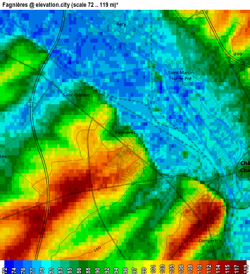
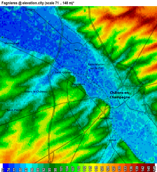
Below is the Elevation map of Fagnières, which displays elevation range with different colors. Scale of the first map is from 72 to 119 m (236 to 390 ft) with average elevation of 89.8 meters (=295 ft) [note 1]
These maps also provides idea of topography and contour of this city, they are displayed at different zoom levels. More info about maps, scale and edge coordinates you can find below images.
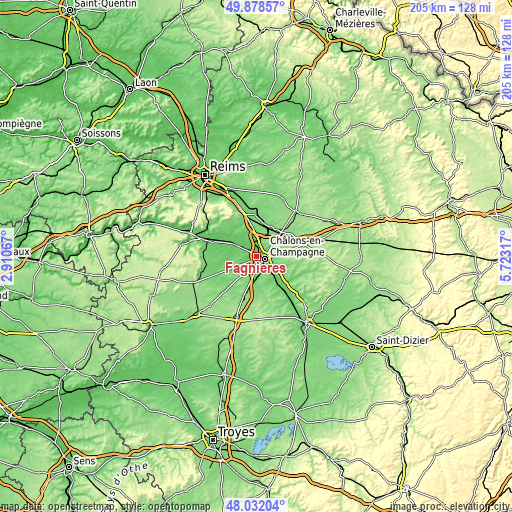
| \ | Map #1 | Map #2 | Topo.Map |
| Scale [m] | 72..119 m | 71..148 m | × |
| Scale [ft] | 236..390 ft | 233..486 ft | × |
| Average | 89.8 m = 295 ft | 96.6 m = 317 ft | × |
| Width | 6.42 km = 4 mi | 12.83 km = 8 mi | 205.3 km = 127.6 mi |
| Height | 6.42 km = 4 mi | 12.83 km = 8 mi | 205.3 km = 127.6 mi |
| ↑Max Latitude | 48.992693° | 49.02152° | 49.87857° |
| Latitude at center | 48.96385° | 48.96385° | 48.96385° |
| ↓Min Latitude | 48.93499° | 48.906113° | 48.03204° |
| ← Min Longitude | 4.272975° | 4.229029° | 2.91067° |
| Longitude center | 4.31692° | 4.31692° | 4.31692° |
| →Max Longitude | 4.360865° | 4.404811° | 5.72317° |
Nearby cities:
Cities around Fagnières sort by population:
• Châlons-en-Champagne elevation 85 m
3.8 km,  106°
106°
• Saint-Memmie 89 m
5.1 km,  104°
104°
• Mourmelon-le-Grand 119 m
19.1 km,  10°
10°
• Courtisols 141 m
14.8 km,  80°
80°
• Vertus 110 m
23.9 km,  254°
254°
• Sarry 84 m
8.2 km,  127°
127°
• Avize 130 m
22.1 km,  272°
272°
• Mareuil-sur-Ay 75 m
22.4 km,  293°
293°
• Tours-sur-Marne 81 m
17.1 km,  303°
303°
• Le Mesnil-sur-Oger 122 m
21.6 km, 265°
• Verzy 160 m
23.1 km,  331°
331°
• Compertrix 108 m
3.3 km,  138°
138°
Multilingual:
 En español:
Fagnières elevación 89 m.
 En France:
Fagnières élévation 89 m.
 Auf Deutsch:
Fagnières höhe über dem Meeresspiegel ist 89 m.

Sources and notes:
- [note 1] Map square and city borders are not equal. Map elevation data is calculated only from area inside that square.
- [src 1] Elevation data from geonames database provided with same terms of usage.
- [src 2] The elevation map of Fagnières is generated using elevation data from NASA's 3 arcsec (90m) resolution SRTM data.
- [src 3] Base (background) map © OpenStreetMap contributors tiles are generated by Geofabrik and OpenTopoMap.
Copyright & License:
This Fagnières Elevation Map is licensed under CC BY-SA. You may reuse any part from this page, if you give a proper credit by linking to this URL:
 More info on terms of use page.