Férel elevation
Férel (Brittany, Morbihan), France elevation is 39 meters and Férel elevation in feet is 128 ft above sea level [src 1]. Férel is a populated place (feature code) with elevation that is 135 meters (443 ft) smaller than average city elevation in France.
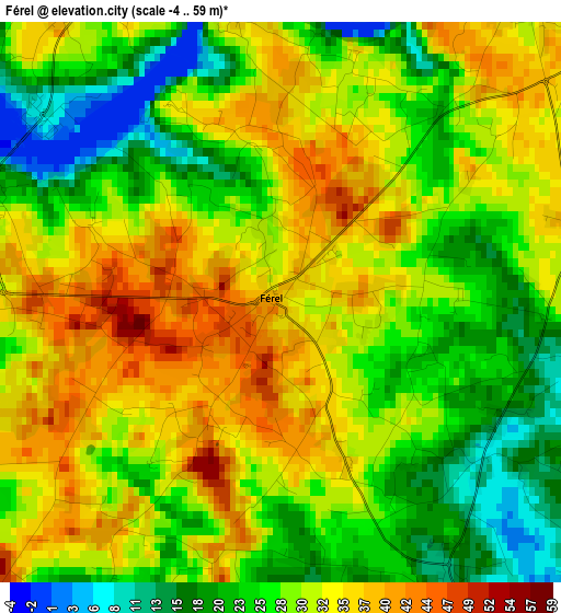
Below is the Elevation map of Férel, which displays elevation range with different colors. Scale of the first map is from -4 to 59 m (-13 to 194 ft) with average elevation of 29.3 meters (=96 ft) [note 1]
These maps also provides idea of topography and contour of this city, they are displayed at different zoom levels. More info about maps, scale and edge coordinates you can find below images.
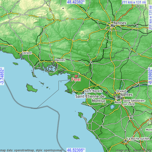
| \ | Map #1 | Topo.Map |
| Scale [m] | -4..59 m | × |
| Scale [ft] | -13..194 ft | × |
| Average | 29.3 m = 96 ft | × |
| Width | 6.6 km = 4.1 mi | 211.3 km = 131.3 mi |
| Height | 6.6 km = 4.1 mi | 211.3 km = 131.3 mi |
| ↑Max Latitude | 47.511721° | 48.42382° |
| Latitude at center | 47.48203° | 47.48203° |
| ↓Min Latitude | 47.452322° | 46.52305° |
| ← Min Longitude | -2.386215° | -3.74852° |
| Longitude center | -2.34227° | -2.34227° |
| →Max Longitude | -2.298325° | -0.93602° |
Nearby cities:
Cities around Férel sort by population:
• Herbignac elevation 19 m
4.2 km,  154°
154°
• Muzillac 27 m
13.1 km,  307°
307°
• Saint-Lyphard 10 m
9.7 km,  163°
163°
• Nivillac 24 m
7.3 km,  37°
37°
• La Chapelle-des-Marais 6 m
8.7 km,  115°
115°
• Péaule 86 m
10.9 km,  354°
354°
• Sainte-Reine-de-Bretagne 9 m
12.1 km,  111°
111°
• Marzan 48 m
6.7 km,  11°
11°
• Pénestin 12 m
9.8 km,  270°
270°
• Saint-Molf 13 m
11.8 km,  211°
211°
• Mesquer 10 m
12.8 km,  223°
223°
• Assérac 15 m
6.9 km, 210°
Multilingual:
 En español:
Férel elevación 39 m.
 En France:
Férel élévation 39 m.


Sources and notes:
- [note 1] Map square and city borders are not equal. Map elevation data is calculated only from area inside that square.
- [src 1] Elevation data from geonames database provided with same terms of usage.
- [src 2] The elevation map of Férel is generated using elevation data from NASA's 3 arcsec (90m) resolution SRTM data.
- [src 3] Base (background) map © OpenStreetMap contributors tiles are generated by Geofabrik and OpenTopoMap.
Copyright & License:
This Férel Elevation Map is licensed under CC BY-SA. You may reuse any part from this page, if you give a proper credit by linking to this URL:
 More info on terms of use page.