Flamanville elevation
Flamanville (Normandy, Manche), France elevation is 74 meters and Flamanville elevation in feet is 243 ft above sea level [src 1]. Flamanville is a populated place (feature code) with elevation that is 100 meters (328 ft) smaller than average city elevation in France.
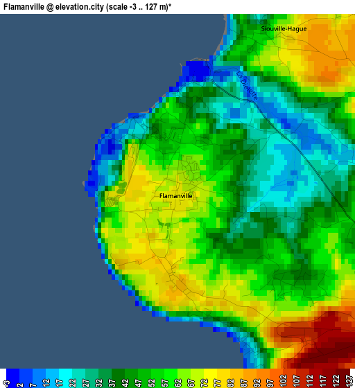
Below is the Elevation map of Flamanville, which displays elevation range with different colors. Scale of the first map is from -3 to 127 m (-10 to 417 ft) with average elevation of 52.4 meters (=172 ft) [note 1]
These maps also provides idea of topography and contour of this city, they are displayed at different zoom levels. More info about maps, scale and edge coordinates you can find below images.
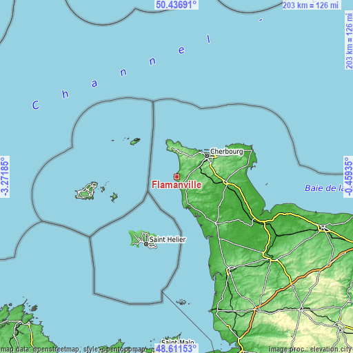
| \ | Map #1 | Topo.Map |
| Scale [m] | -3..127 m | × |
| Scale [ft] | -10..417 ft | × |
| Average | 52.4 m = 172 ft | × |
| Width | 6.34 km = 3.9 mi | 203 km = 126.1 mi |
| Height | 6.34 km = 3.9 mi | 202.9 km = 126.1 mi |
| ↑Max Latitude | 49.561253° | 50.43691° |
| Latitude at center | 49.53274° | 49.53274° |
| ↓Min Latitude | 49.504211° | 48.61153° |
| ← Min Longitude | -1.909545° | -3.27185° |
| Longitude center | -1.8656° | -1.8656° |
| →Max Longitude | -1.821655° | -0.45935° |
Nearby cities:
Cities around Flamanville sort by population:
• Octeville elevation 95 m
19.1 km,  57°
57°
• Querqueville 5 m
19.1 km,  41°
41°
• Bricquebec 47 m
18.2 km,  112°
112°
• Les Pieux 117 m
4.8 km,  117°
117°
• Barneville-Plage 8 m
19.7 km,  158°
158°
• Urville-Nacqueville 10 m
18.3 km,  30°
30°
• Barneville-Carteret 19 m
18.6 km,  153°
153°
• Beaumont-Hague 163 m
14.7 km,  7°
7°
• Sottevast 41 m
19.8 km,  92°
92°
• Tollevast 90 m
17.8 km,  74°
74°
• Martinvast 60 m
16.1 km, 64°
• Surtainville 12 m
9 km, 154°
Multilingual:
 En español:
Flamanville elevación 74 m.
 En France:
Flamanville élévation 74 m.
 Auf Deutsch:
Flamanville höhe über dem Meeresspiegel ist 74 m.

Sources and notes:
- [note 1] Map square and city borders are not equal. Map elevation data is calculated only from area inside that square.
- [src 1] Elevation data from geonames database provided with same terms of usage.
- [src 2] The elevation map of Flamanville is generated using elevation data from NASA's 3 arcsec (90m) resolution SRTM data.
- [src 3] Base (background) map © OpenStreetMap contributors tiles are generated by Geofabrik and OpenTopoMap.
Copyright & License:
This Flamanville Elevation Map is licensed under CC BY-SA. You may reuse any part from this page, if you give a proper credit by linking to this URL:
 More info on terms of use page.