Flayosc elevation
Flayosc (Provence-Alpes-Côte d'Azur, Var), France elevation is 250 meters and Flayosc elevation in feet is 820 ft above sea level [src 1]. Flayosc is a populated place (feature code) with elevation that is 76 meters (249 ft) bigger than average city elevation in France.
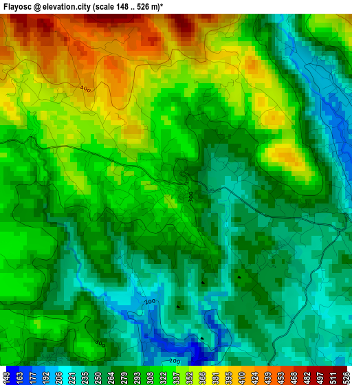
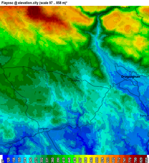
Below is the Elevation map of Flayosc, which displays elevation range with different colors. Scale of the first map is from 148 to 526 m (486 to 1726 ft) with average elevation of 299.1 meters (=981 ft) [note 1]
These maps also provides idea of topography and contour of this city, they are displayed at different zoom levels. More info about maps, scale and edge coordinates you can find below images.
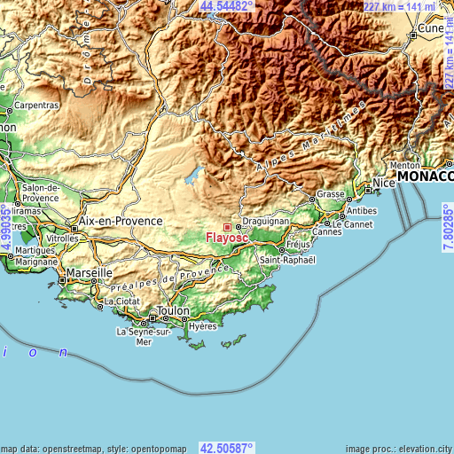
| \ | Map #1 | Map #2 | Topo.Map |
| Scale [m] | 148..526 m | 97..858 m | × |
| Scale [ft] | 486..1726 ft | 318..2815 ft | × |
| Average | 299.1 m = 981 ft | 336.5 m = 1104 ft | × |
| Width | 7.08 km = 4.4 mi | 14.17 km = 8.8 mi | 226.7 km = 140.9 mi |
| Height | 7.08 km = 4.4 mi | 14.17 km = 8.8 mi | 226.7 km = 140.9 mi |
| ↑Max Latitude | 43.56581° | 43.597644° | 44.54482° |
| Latitude at center | 43.53396° | 43.53396° | 43.53396° |
| ↓Min Latitude | 43.502093° | 43.470209° | 42.50587° |
| ← Min Longitude | 6.352655° | 6.308709° | 4.99035° |
| Longitude center | 6.3966° | 6.3966° | 6.3966° |
| →Max Longitude | 6.440545° | 6.484491° | 7.80285° |
Nearby cities:
Cities around Flayosc sort by population:
• Draguignan elevation 193 m
5.5 km,  86°
86°
• Lorgues 216 m
5.3 km,  212°
212°
• Vidauban 74 m
12.2 km,  166°
166°
• Les Arcs 74 m
10.3 km,  139°
139°
• Trans-en-Provence 168 m
8 km,  115°
115°
• La Motte 80 m
12 km,  111°
111°
• Figanières 311 m
9 km,  64°
64°
• Montferrat 515 m
11 km,  38°
38°
• Taradeau 77 m
9.2 km,  164°
164°
• Le Thoronet 132 m
11.8 km,  219°
219°
• Callas 385 m
13.2 km, 60°
• Villecroze 337 m
11.1 km,  298°
298°
Multilingual:
 En español:
Flayosc elevación 250 m.
 En France:
Flayosc élévation 250 m.


Sources and notes:
- [note 1] Map square and city borders are not equal. Map elevation data is calculated only from area inside that square.
- [src 1] Elevation data from geonames database provided with same terms of usage.
- [src 2] The elevation map of Flayosc is generated using elevation data from NASA's 3 arcsec (90m) resolution SRTM data.
- [src 3] Base (background) map © OpenStreetMap contributors tiles are generated by Geofabrik and OpenTopoMap.
Copyright & License:
This Flayosc Elevation Map is licensed under CC BY-SA. You may reuse any part from this page, if you give a proper credit by linking to this URL:
 More info on terms of use page.