Fourchambault elevation
Fourchambault (Bourgogne-Franche-Comté, Département de la Nièvre), France elevation is 180 meters and Fourchambault elevation in feet is 591 ft above sea level [src 1]. Fourchambault is a populated place (feature code) with elevation that is 6 meters (20 ft) bigger than average city elevation in France.
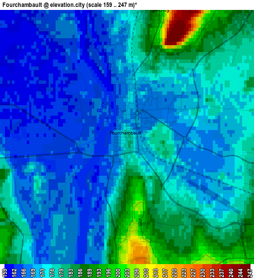
Below is the Elevation map of Fourchambault, which displays elevation range with different colors. Scale of the first map is from 159 to 247 m (522 to 810 ft) with average elevation of 174.4 meters (=572 ft) [note 1]
These maps also provides idea of topography and contour of this city, they are displayed at different zoom levels. More info about maps, scale and edge coordinates you can find below images.
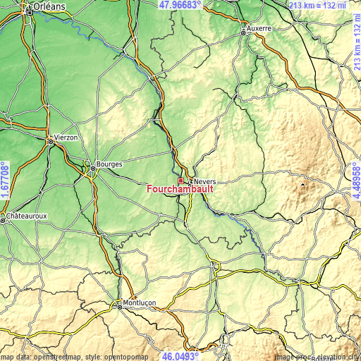
| \ | Map #1 | Map #2 | Topo.Map |
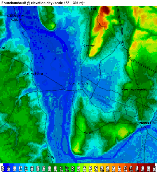
| Scale [m] | 159..247 m | 155..301 m | × |
| Scale [ft] | 522..810 ft | 509..988 ft | × |
| Average | 174.4 m = 572 ft | 189.7 m = 622 ft | × |
| Width | 6.66 km = 4.1 mi | 13.33 km = 8.3 mi | 213.2 km = 132.5 mi |
| Height | 6.66 km = 4.1 mi | 13.33 km = 8.3 mi | 213.2 km = 132.5 mi |
| ↑Max Latitude | 47.046623° | 47.076559° | 47.96683° |
| Latitude at center | 47.01667° | 47.01667° | 47.01667° |
| ↓Min Latitude | 46.9867° | 46.956714° | 46.0493° |
| ← Min Longitude | 3.039385° | 2.995439° | 1.67708° |
| Longitude center | 3.08333° | 3.08333° | 3.08333° |
| →Max Longitude | 3.127275° | 3.171221° | 4.48958° |
Nearby cities:
Cities around Fourchambault sort by population:
• Nevers elevation 192 m
6.5 km,  117°
117°
• Varennes-Vauzelles 220 m
4.3 km,  89°
89°
• Garchizy 215 m
3.6 km,  15°
15°
• Coulanges-lès-Nevers 187 m
8 km,  99°
99°
• Marzy 209 m
4 km,  168°
168°
• Pougues-les-Eaux 201 m
6.6 km,  11°
11°
• Urzy 190 m
9.7 km,  68°
68°
• Challuy 199 m
8.9 km,  146°
146°
• Sermoise-sur-Loire 186 m
10.6 km,  134°
134°
• Jouet-sur-l'Aubois 172 m
8 km,  293°
293°
• Cours-les-Barres 178 m
4 km,  283°
283°
• Cuffy 185 m
6.4 km,  201°
201°
Multilingual:
 En español:
Fourchambault elevación 180 m.
 En France:
Fourchambault élévation 180 m.
 Auf Deutsch:
Fourchambault höhe über dem Meeresspiegel ist 180 m.

Sources and notes:
- [note 1] Map square and city borders are not equal. Map elevation data is calculated only from area inside that square.
- [src 1] Elevation data from geonames database provided with same terms of usage.
- [src 2] The elevation map of Fourchambault is generated using elevation data from NASA's 3 arcsec (90m) resolution SRTM data.
- [src 3] Base (background) map © OpenStreetMap contributors tiles are generated by Geofabrik and OpenTopoMap.
Copyright & License:
This Fourchambault Elevation Map is licensed under CC BY-SA. You may reuse any part from this page, if you give a proper credit by linking to this URL:
 More info on terms of use page.