Gignac elevation
Gignac (Occitanie, Département de l'Hérault), France elevation is 80 meters and Gignac elevation in feet is 262 ft above sea level [src 1]. Gignac is a populated place (feature code) with elevation that is 94 meters (308 ft) smaller than average city elevation in France.
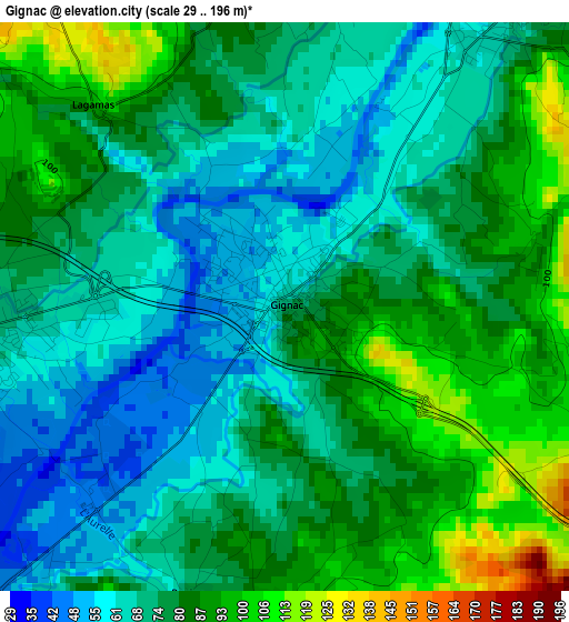
Below is the Elevation map of Gignac, which displays elevation range with different colors. Scale of the first map is from 29 to 196 m (95 to 643 ft) with average elevation of 76.6 meters (=251 ft) [note 1]
These maps also provides idea of topography and contour of this city, they are displayed at different zoom levels. More info about maps, scale and edge coordinates you can find below images.
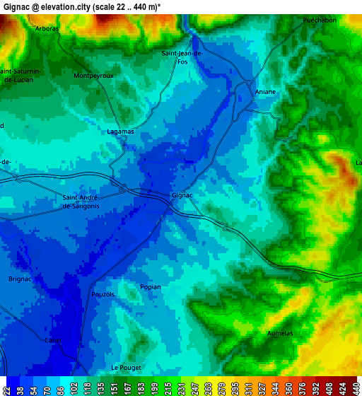
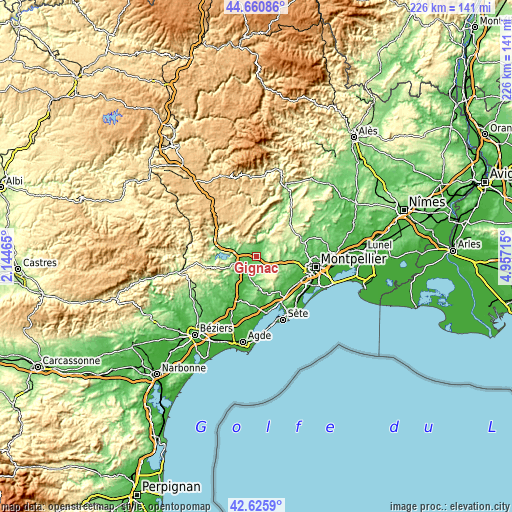
| \ | Map #1 | Map #2 | Topo.Map |
| Scale [m] | 29..196 m | 22..440 m | × |
| Scale [ft] | 95..643 ft | 72..1444 ft | × |
| Average | 76.6 m = 251 ft | 127.4 m = 418 ft | × |
| Width | 7.07 km = 4.4 mi | 14.14 km = 8.8 mi | 226.3 km = 140.6 mi |
| Height | 7.07 km = 4.4 mi | 14.14 km = 8.8 mi | 226.3 km = 140.6 mi |
| ↑Max Latitude | 43.683788° | 43.715559° | 44.66086° |
| Latitude at center | 43.652° | 43.652° | 43.652° |
| ↓Min Latitude | 43.620195° | 43.588373° | 42.6259° |
| ← Min Longitude | 3.506955° | 3.463009° | 2.14465° |
| Longitude center | 3.5509° | 3.5509° | 3.5509° |
| →Max Longitude | 3.594845° | 3.638791° | 4.95715° |
Nearby cities:
Cities around Gignac sort by population:
• Saint-André-de-Sangonis elevation 70 m
4 km,  262°
262°
• Paulhan 44 m
14.6 km,  210°
210°
• Montarnaud 124 m
11.8 km,  92°
92°
• Aniane 73 m
4.7 km,  39°
39°
• Vailhauquès 130 m
13.8 km,  80°
80°
• Saint-Pargoire 81 m
14.1 km,  190°
190°
• Le Pouget 112 m
7 km,  197°
197°
• Murviel-lès-Montpellier 131 m
15.9 km,  109°
109°
• Aspiran 77 m
12.5 km,  220°
220°
• Saint-Jean-de-Fos 106 m
5.4 km,  0°
0°
• Montpeyroux 152 m
6.1 km,  323°
323°
• Nébian 125 m
10.9 km,  242°
242°
Multilingual:
 En español:
Gignac elevación 80 m.
 En France:
Gignac élévation 80 m.


Sources and notes:
- [note 1] Map square and city borders are not equal. Map elevation data is calculated only from area inside that square.
- [src 1] Elevation data from geonames database provided with same terms of usage.
- [src 2] The elevation map of Gignac is generated using elevation data from NASA's 3 arcsec (90m) resolution SRTM data.
- [src 3] Base (background) map © OpenStreetMap contributors tiles are generated by Geofabrik and OpenTopoMap.
Copyright & License:
This Gignac Elevation Map is licensed under CC BY-SA. You may reuse any part from this page, if you give a proper credit by linking to this URL:
 More info on terms of use page.