Gondrecourt-le-Château elevation
Gondrecourt-le-Château (Grand Est, Meuse), France elevation is 310 meters and Gondrecourt-le-Château elevation in feet is 1017 ft above sea level [src 1]. Gondrecourt-le-Château is a populated place (feature code) with elevation that is 136 meters (446 ft) bigger than average city elevation in France.
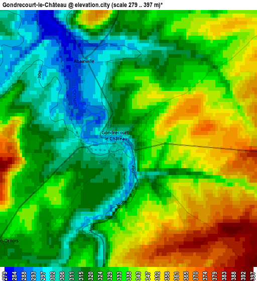
Below is the Elevation map of Gondrecourt-le-Château, which displays elevation range with different colors. Scale of the first map is from 279 to 397 m (915 to 1302 ft) with average elevation of 330.8 meters (=1085 ft) [note 1]
These maps also provides idea of topography and contour of this city, they are displayed at different zoom levels. More info about maps, scale and edge coordinates you can find below images.
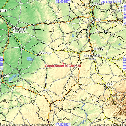
| \ | Map #1 | Topo.Map |
| Scale [m] | 279..397 m | × |
| Scale [ft] | 915..1302 ft | × |
| Average | 330.8 m = 1085 ft | × |
| Width | 6.47 km = 4 mi | 207.2 km = 128.7 mi |
| Height | 6.47 km = 4 mi | 207.1 km = 128.7 mi |
| ↑Max Latitude | 48.542763° | 49.43667° |
| Latitude at center | 48.51366° | 48.51366° |
| ↓Min Latitude | 48.48454° | 47.57353° |
| ← Min Longitude | 5.466635° | 4.10433° |
| Longitude center | 5.51058° | 5.51058° |
| →Max Longitude | 5.554525° | 6.91683° |
Nearby cities:
Cities around Gondrecourt-le-Château sort by population:
• Neufchâteau elevation 286 m
22.3 km,  142°
142°
• Ligny-en-Barrois 225 m
23.7 km,  325°
325°
• Foug 256 m
27.8 km,  47°
47°
• Liffol-le-Grand 310 m
22.4 km,  166°
166°
• Vaucouleurs 249 m
15.2 km, 49°
• Void-Vacon 241 m
20.4 km,  22°
22°
• Vacon 252 m
18.5 km, 20°
• Euville 234 m
27.6 km, 17°
• Chevillon 186 m
28 km,  273°
273°
• Domgermain 238 m
27.5 km,  58°
58°
• Blénod-lès-Toul 263 m
25.8 km,  68°
68°
• Velaines 216 m
25.5 km,  323°
323°
Multilingual:
 En español:
Gondrecourt-le-Château elevación 310 m.
 En France:
Gondrecourt-le-Château élévation 310 m.
 Auf Deutsch:
Gondrecourt-le-Château höhe über dem Meeresspiegel ist 310 m.
 На русском:
Gondrecourt-le-Château высота над уровнем моря 310 м
Sources and notes:
- [note 1] Map square and city borders are not equal. Map elevation data is calculated only from area inside that square.
- [src 1] Elevation data from geonames database provided with same terms of usage.
- [src 2] The elevation map of Gondrecourt-le-Château is generated using elevation data from NASA's 3 arcsec (90m) resolution SRTM data.
- [src 3] Base (background) map © OpenStreetMap contributors tiles are generated by Geofabrik and OpenTopoMap.
Copyright & License:
This Gondrecourt-le-Château Elevation Map is licensed under CC BY-SA. You may reuse any part from this page, if you give a proper credit by linking to this URL:
 More info on terms of use page.