Guémené-sur-Scorff elevation
Guémené-sur-Scorff (Brittany, Morbihan), France elevation is 178 meters and Guémené-sur-Scorff elevation in feet is 584 ft above sea level [src 1]. Guémené-sur-Scorff is a populated place (feature code) with elevation that is 4 meters (13 ft) bigger than average city elevation in France.
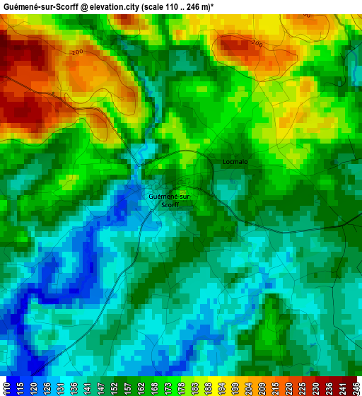
Below is the Elevation map of Guémené-sur-Scorff, which displays elevation range with different colors. Scale of the first map is from 110 to 246 m (361 to 807 ft) with average elevation of 159.8 meters (=524 ft) [note 1]
These maps also provides idea of topography and contour of this city, they are displayed at different zoom levels. More info about maps, scale and edge coordinates you can find below images.
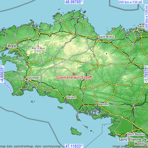
| \ | Map #1 | Topo.Map |
| Scale [m] | 110..246 m | × |
| Scale [ft] | 361..807 ft | × |
| Average | 159.8 m = 524 ft | × |
| Width | 6.53 km = 4.1 mi | 209 km = 129.9 mi |
| Height | 6.53 km = 4.1 mi | 209 km = 129.9 mi |
| ↑Max Latitude | 48.096029° | 48.99785° |
| Latitude at center | 48.06667° | 48.06667° |
| ↓Min Latitude | 48.037294° | 47.11833° |
| ← Min Longitude | -3.243945° | -4.60625° |
| Longitude center | -3.2° | -3.2° |
| →Max Longitude | -3.156055° | -1.79375° |
Nearby cities:
Cities around Guémené-sur-Scorff sort by population:
• Cléguérec elevation 156 m
11.6 km,  55°
55°
• Bubry 103 m
11.7 km,  169°
169°
• Inguiniel 139 m
11.7 km,  210°
210°
• Le Sourn 100 m
16 km,  99°
99°
• Malguénac 200 m
11.1 km,  82°
82°
• Melrand 68 m
11.8 km,  145°
145°
• Neulliac 118 m
17.5 km,  66°
66°
• Guern 140 m
9.1 km,  117°
117°
• Ploërdut 196 m
6.8 km,  289°
289°
• Berné 107 m
16.5 km,  241°
241°
• Priziac 161 m
16.1 km,  270°
270°
• Plouray 194 m
16.4 km,  302°
302°
Multilingual:
 En español:
Guémené-sur-Scorff elevación 178 m.
 En France:
Guémené-sur-Scorff élévation 178 m.
 Auf Deutsch:
Guémené-sur-Scorff höhe über dem Meeresspiegel ist 178 m.

Sources and notes:
- [note 1] Map square and city borders are not equal. Map elevation data is calculated only from area inside that square.
- [src 1] Elevation data from geonames database provided with same terms of usage.
- [src 2] The elevation map of Guémené-sur-Scorff is generated using elevation data from NASA's 3 arcsec (90m) resolution SRTM data.
- [src 3] Base (background) map © OpenStreetMap contributors tiles are generated by Geofabrik and OpenTopoMap.
Copyright & License:
This Guémené-sur-Scorff Elevation Map is licensed under CC BY-SA. You may reuse any part from this page, if you give a proper credit by linking to this URL:
 More info on terms of use page.