Guer elevation
Guer (Brittany, Morbihan), France elevation is 46 meters and Guer elevation in feet is 151 ft above sea level [src 1]. Guer is a populated place (feature code) with elevation that is 128 meters (420 ft) smaller than average city elevation in France.
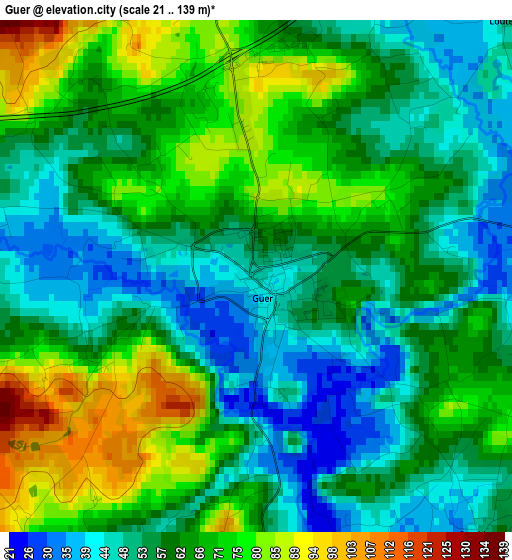
Below is the Elevation map of Guer, which displays elevation range with different colors. Scale of the first map is from 21 to 139 m (69 to 456 ft) with average elevation of 61.2 meters (=201 ft) [note 1]
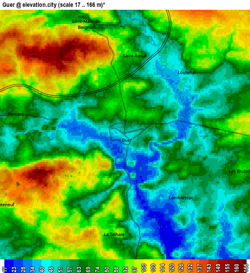
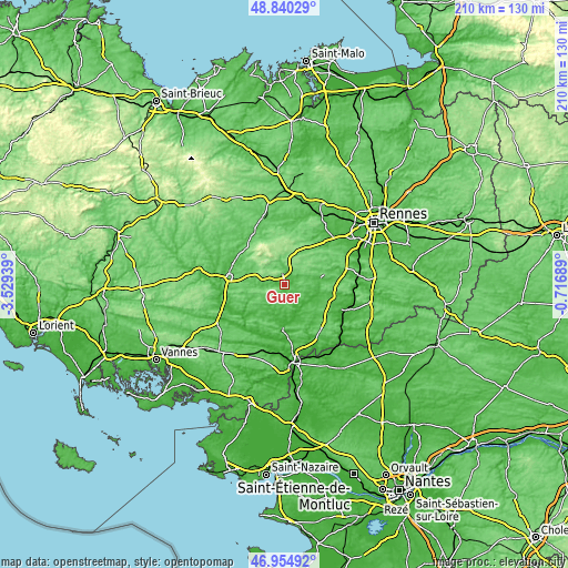
These maps also provides idea of topography and contour of this city, they are displayed at different zoom levels. More info about maps, scale and edge coordinates you can find below images.
| \ | Map #1 | Map #2 | Topo.Map |
| Scale [m] | 21..139 m | 17..166 m | × |
| Scale [ft] | 69..456 ft | 56..545 ft | × |
| Average | 61.2 m = 201 ft | 75.3 m = 247 ft | × |
| Width | 6.55 km = 4.1 mi | 13.1 km = 8.1 mi | 209.6 km = 130.2 mi |
| Height | 6.55 km = 4.1 mi | 13.1 km = 8.1 mi | 209.6 km = 130.2 mi |
| ↑Max Latitude | 47.93564° | 47.965074° | 48.84029° |
| Latitude at center | 47.90619° | 47.90619° | 47.90619° |
| ↓Min Latitude | 47.876723° | 47.847239° | 46.95492° |
| ← Min Longitude | -2.167085° | -2.211031° | -3.52939° |
| Longitude center | -2.12314° | -2.12314° | -2.12314° |
| →Max Longitude | -2.079195° | -2.035249° | -0.71689° |
Nearby cities:
Cities around Guer sort by population:
• Plélan-le-Grand elevation 137 m
10.7 km,  9°
9°
• Carentoir 48 m
10 km,  184°
184°
• Maure-de-Bretagne 46 m
10 km,  98°
98°
• La Gacilly 17 m
15.6 km, 182°
• Sixt-sur-Aff 45 m
14.8 km,  167°
167°
• Campénéac 79 m
13.9 km,  294°
294°
• Paimpont 158 m
12.9 km,  344°
344°
• Ruffiac 57 m
15.4 km,  230°
230°
• Augan 85 m
11.7 km,  277°
277°
• Caro 111 m
15.3 km,  252°
252°
• Maxent 116 m
10.9 km,  37°
37°
• Beignon 122 m
8.1 km,  334°
334°
Multilingual:
 En español:
Guer elevación 46 m.
 En France:
Guer élévation 46 m.


Sources and notes:
- [note 1] Map square and city borders are not equal. Map elevation data is calculated only from area inside that square.
- [src 1] Elevation data from geonames database provided with same terms of usage.
- [src 2] The elevation map of Guer is generated using elevation data from NASA's 3 arcsec (90m) resolution SRTM data.
- [src 3] Base (background) map © OpenStreetMap contributors tiles are generated by Geofabrik and OpenTopoMap.
Copyright & License:
This Guer Elevation Map is licensed under CC BY-SA. You may reuse any part from this page, if you give a proper credit by linking to this URL:
 More info on terms of use page.